


SUUNTOブログ

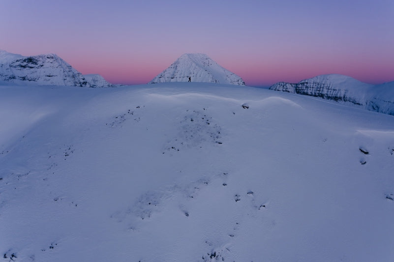
Living peak adventure: find your starting point
The Living Peak Adventure article series gives you everything you need to know to find, create and navigate smoking routes. The series covers:
How to find hot routes with Suunto app heatmaps
How to find popular starting points
How to create your own routes
How to share your routes with friends
How to navigate a route outdoors
How to pinpoint the best starting spots
Say you’ve identified an intriguing mountain range or forest on the map that looks like prime trail running territory. Or maybe you’ve discovered a nice cross-country skiing loop on Suunto app heatmaps, but don’t know the area so well. Now, you just need to know where to park your car and start your adventure; let the Suunto community show you.
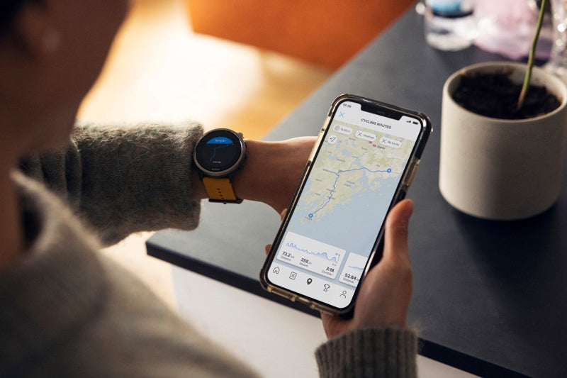
Popular starting points are shown in heatmaps as little circles the same color as the activity type you have selected. These circles indicate a parking lot, a trail head or other starting points, such as outside a hotel or apartment complex. They show you where the local Suunto community begins its adventures.
Tap and go
Next, simply tap on a circle you’d like to use as a starting point and an information box with options will appear at the bottom half of your screen. The box confirms it’s a popular starting point, and provides other useful info, such as the sunrise and sunset times, the temperature and coordinates.
Below that you can choose to save the starting point as a POI (point of interest), or to start or end your activity there. Remember you can zoom in on your screen to more clearly see the location and what’s around it so when you arrive there you know what to look for.
Suunto app has heatmaps for 16 different activity types from running, trail running, cycling and mountain biking to activities like ski touring and open water swimming. With the Suunto community behind you, you’ll always find awesome routes and know exactly where to start!
Popular routes
To find popular routes, open the Suunto app map and swipe up from the bottom of the screen. A menu window will open that shows nearby popular routes. Once you’ve found a popular route based on your activity type, tap the route and a box will appear on your screen allowing you to save it and sync it with your watch. You’re good to go.

Living peak adventure: find routes that rock
At Suunto, our purpose is to help you have unforgettable outdoor experiences. We want to make it as easy as possible for you to find, create and navigate trails that simply rock.
So we’ve put together the Living Peak Adventure series so everything you need to know is all in one place. We’ll cover:
How to find hot routes with Suunto app heatmaps
How to find popular starting points
How to create your own routes
How to share your routes with friends
How to navigate a route outdoors
Master this, and your best adventures are still waiting!
Find hot routes with Suunto app heatmaps
Imagine you’ve moved across town or to a new city altogether and you’re looking for some sweet local spots to go mountain biking or trail running, Suunto app heatmaps will show you what’s hot with the locals.
You can view Suunto heatmaps also in 3D!
Based on millions of workouts, Heatmaps highlight the most frequented training spots for more than 16 sports in locations around the world. Just select the activity type for your heatmap, whether trail running, cycling, swimming and so on, and the more our community works out somewhere, the brighter the lines in our maps become (each sport has its own color), making it easy for you to see where to head next. There are five map styles for you to toggle between, depending on your sport, season and what you are looking for.
You can also use heatmaps to identify locations not so popular with our community if you are searching for somewhere quieter or less frequented to go. Look for duller colored lines.
How to use Suunto app heatmaps
First, open Suunto app on your device, then open the map by tapping the location pointer icon on the bottom right corner. Now select the heatmap layer for your sport or activity type and choose your preferred map style. Zoom in to look more closely at particular trails or areas of interest. The brighter the lines, the more popular those routes are.
Switch from 2D to 3D
You can also switch between a standard 2D map and a 3D map. The former gives you an overview of the location and the popular routes, while the latter, when you zoom in, gives a better sense of the topography - hills, valley and mountains and so on.
Switch between 3D and 2D maps and different map layers to get the most out of heatmaps.
Whether you select the 2D or 3D map, you can zoom in and create your own route. Simply tap the plus symbol on the lower right side and tap where on the map you’d like your route to start. Then keep tapping on the map where you’d like your route to extend to. Suunto app will calculate the distance, vertical meters and estimated duration and present it at the bottom of the screen as you create your route. As you build it, you can switch between different map styles, 2D and 3D, and with heatmaps on and off.
Once you are ready, save your route, sync it to your Suunto watch and get out there!
Learn more about the navigation features, map styles and routes with the Suunto app 🔺
Stay tuned for the rest of the five part series to learn how to live peak adventure with your watch from Suunto!

How to mix it up when you love too many outdoor sports
With winter deepening in Boulder, Colorado Suunto athlete Anton Krupicka is dusting off his ski gear and getting ready for some big skimo days in the mountains.
This builds on a huge summer of adventure that saw him complete an epic tour that involved cycling to five different 4000 m mountains, running up as far as possible and then climbing to each summit.
We wondered how in the world Anton finds time to train in all these disciplines and how he strikes a balance. Read on for our Q&A with him.
Read more about Anton here!
What adventures have you been on recently?
I had a pretty busy summer. In June, I rode the Unbound XL gravel race - a 360 mile (579 km) bike race in the Flint Hills of Kansas. It was the farthest I’ve ever ridden in one stretch.
In July, I completed a 2300 mile (4000 km) bike/run/climb tour through Utah, Idaho, Wyoming, Montana, and Colorado where I linked together six different remote technical mountains, starting and finishing at my doorstep in Boulder, Colorado: Kings Peak (13,528 ft / 4123 m), the high point of Utah; the Grand Teton (13,775 ft / 4198 m); Granite Peak (12,807 ft / 3903 m), the high point of Montana; Cloud Peak (13,164 ft / 4012 m), the high point of Wyoming's Bighorn Range; Gannett Peak (13,804 ft / 4207 m), the high point of Wyoming; and Longs Peak (14,255 ft / 4345 m), my backyard mountain here in Boulder, Colorado. I dubbed this trip “Sagebrush & Summits”; those three weeks of riding, running, and climbing were the highlight of my summer.
Finally, in August I ran the Leadville 100, my first ultramarathon in more than six years. This fall, I took a trip back east to North Carolina where we enjoyed some climbing and also a four-day bikepacking trip along the Blue Ridge between Boone and Asheville. That was more for relaxation and recovery, though.
That’s huge! Anything coming up?
Right now, I’m looking forward to skimo racing this winter and hopefully a bikepacking trip to southern Arizona over the winter. I’m already scheming a bikepacking tour for next summer that can top Sagebrush & Summits, though!
You love to mix disciplines; how do you approach this from a training perspective? How do you build in enough recovery time?
It’s all intuitive. I tend to specialize a little bit more as a key objective approaches, but in general I’m trying to balance running, climbing and cycling, and skiing in the winter.
A typical week will probably see me biking 3-4 days, running 2-4 days, and climbing 2-3 days. I do some kind of cardio every day. I typically go on a bike ride after climbing (after having already ridden to the crag), and I use the bike/climb days as recovery from the running days. On days that I run, I usually only run. That’s the general thought process.
What I do is further influenced by the weather forecast - I’m constantly paying attention to weather patterns! - as I prefer to run on cooler or wetter days, and ride/climb on sunnier/drier days, and, of course, run/climb in the alpine when the weather is favorable.
What signals do you look for in your body to determine where you’re at and when you need more recovery time?
Everything is ultimately determined by what my body is telling me. Specifically, how my Achilles is feeling and how it’s responding to the stresses I’m placing on it. As for taking an easier day, I decide that in the moment. Unless I have some key session that I want to be sure to hit before a goal (say, a long run before an ultra or a long bike ride before a bike race), all of my easy/recovery days are determined by how my energy levels are feeling on the day. If I’m feeling good and my body is feeling sound, I’ll push the pace or the distance, or both, in a session. But there are plenty of times where I’ve wanted to hit a harder session and I just don’t have the energy, so I go easy or shorter, sometimes a lot shorter.
What have been some of the key lessons you’ve learned about mixing it up that might be helpful to others who are doing the same thing?
I think you have to realize that you can really only be progressing meaningfully in one activity at a time. That doesn’t mean that I’m not pursuing other activities simultaneously, it’s just that they’re temporarily in maintenance mode. Also, as my previous answer made clear, it’s extremely important to listen to your body and your energy levels and know how they will react to various activities.
For me, running is always the most intense and abusive pursuit. Recovery from that requires only cycling, and probably at a low intensity if I’m really tired. Climbing shouldn’t be classified as active recovery, as the climbing I do usually involves a fair amount of vertical gain/loss in hiking and descending and several multi-pitch routes where more vert is being gained and lost. And if I’m trying to climb hard - at my technical limit - then that’s only going to be possible if I’m not overly tired from running or riding. I love climbing as much as running and cycling - maybe even more - but I rarely prioritize it in any meaningful way. It necessarily takes a back seat because it doesn’t really do anything to further my development in endurance pursuits, where I actually have talent.
Are there any classic pitfalls to avoid?
Like I said above, I think it’s important to not try to progress in more than one activity at a time. I think that usually just ends up being counterproductive.
How has mixing it up made you a better athlete? I guess fun is an important benefit?
Embracing a variety of mountain sports has made me a more well-rounded athlete. It’s also extended my running career - there’s no way that I could only run now and stay healthy enough to race and have it be sustainable. That’s the main benefit.
I don’t like the word “fun”. I think the way it’s typically used is too broad and not incisive enough. What do people really mean when they say “fun”? Often, I think what they really mean is “rewarding”, “satisfying”, or “with joy”. To me, those words imply hard work, challenge, discomfort, and/or intentionality. None of those things, I think, really apply to the textbook definition of “fun”.
The most important benefit to me of mixing up activities is that it has allowed me to grow and learn so much more about each activity and, concurrently, about myself. Having spent several years now pursuing all of these things, I can’t imagine ever going back to being only a runner.
Do you think mixing it up in the way you are is becoming more popular today?
Hmmm, I don’t know. I think to truly reach your potential in a given pursuit you have to be singular in your focus. I did that for a decade-plus with running. But it eventually became physically unsustainable. I think it’s fine to go through phases or seasons in one’s life. I doubt that pursuing multiple sports at the same time is anything new. But, with social media and the internet, we’re probably all just more aware of people who are doing that.
All images by Fred Marmsater

Play your adventures back in 3D in Suunto app!
Last fall we introduced 3D maps in Suunto app so you can plan and review your tracks on a 3D map. Now we've taken this further - you can now enjoy your adventures as 3D video animations. Simply go to your activity, hit the play button, and enjoy the views.
Hit the play button in Suunto app to play your adventures back in Suunto app!
Share a 3D map animation
If you want your friends to experience your trip, share a link to the activity with them and they will be able to see a 3D animation as well – even on big screen. To share an activity, tap the sharing icon and select ‘Share link to activity’. Add a description and photos to enhance the experience and to tell the full story.
To see how those shared activities look, follow along on a 117-kilometer ski tour with Greg Hill here!

Calling winter sports fans: help researchers reduce avalanche fatalities
A first of its kind research project in Norway is inviting Suunto users to help them gain insights into how we make decisions in avalanche terrain, and what we can do to reduce avalanche accidents.
The Center for Avalanche Research and Education (CARE) at UiT the Arctic University of Norway wishes to follow 10 000 winter sports fans for 10 years to examine how we make decisions in avalanche terrain, and how we can all be safer.
To join the CAREpanel and help with this important, and first of its kind longitudinal study, you must be involved in a winter sport like skiing, snowboarding, ice-climbing, snowmobiling, hunting and so on.
Photo by Audun Hetland
How to contribute
You can contribute by joining the longitudinal study at www.carepanel.no and also by sharing your activity data with the avalanche researchers at CARE. To send your activity data to the researchers, go to the activity in Suunto app, tap the three dots on top right and select 'Export GPX workout'.
Why it’s important
Nine out of 10 fatal avalanche accidents are triggered by the victim or someone in their party. According to EAWS, the European Avalanche Warning Service, there were 130 avalanche related fatalities in Europe alone in 2020-2021. By understanding and improving decision making CARE aims to save lives.
Normal short term studies do not provide much in the way of insights into human factors and their impact in triggering avalanches. By following such a large number of people over time the CAREpanel research project will reveal how education or experience impact people’s perception of risk and their following decisions.
Photo by Audun Hetland
What’s involved
The carepanel consists of an introductory survey and a yearly survey. The surveys take about 15 minutes to complete. The CARE panelist will also be asked to join a GPS survey. If you share your GPS data you will get an offer to answer a few questions about the tour in avalanche terrain.
The researchers will run the GPS track through a terrain model and compare it with the current avalanche conditions from the warning service varsom.no. This will let them create a rough estimation of exposure risk under the current conditions. In the future the researchers also aim to provide feedback to the participants based on their GPS tracks.
Some participants may also be invited to join additional short studies. These are optional.
How to sign up
To become a CARE paneilist, first read important information for participants. Then complete the CARE panel recruitment survey.
Lead image: Jaakko Posti / Arctic Lines

6 tips for mountain navigation
Suunto athlete and intrepid Finnish freerider Antti Autti is bracing himself for days of bone chilling temperatures as he searches for snowboarding lines in mountains above the Arctic Circle.
Season two of his Arctic Lines project is underway. The goal is to ride 30 unique, unridden or iconic lines in the frozen wilds of northern Finland, Sweden and Norway. Getting to each line is no walk in the park. He and his crew must contend with long approaches, minus temperatures, the poor visibility of the Arctic’s polar night, difficult to predict snow conditions, blizzards and obstacles.
In this article, Antti guides us through how he breaks down each trip and how he navigates to each line and back.
Watch each episode of Arctic Lines as it drops here!
Have a plan
This sounds obvious, but the importance of having a thought-through and agreed upon plan can’t be overstated. Having a plan b is also important. Make sure each person in your group knows the plan and has agreed to it. To achieve this, Antti creates routes in Suunto app and shares them with his crew for feedback. If everyone is happy, he then creates GPX files and syncs them with their Suunto 9 Peak watches.
Click here for Antti’s 8 planning steps!
Start cool
You reach the road end and get out of your toasty warm car and into the biting cold air. Don’t make the mistake of piling too many layers on too soon. It’s better to start a little cold and then warm up. Otherwise you’ll have to stop after 20 minutes to remove layers.
Let your watch guide you
“It’s really helpful to have the route planned in advance and to follow it on our watches,” Antti says. “When I’m at home and draw the route in Suunto app I can’t see all the obstacles we’ll encounter on the ground. But following the route with my watch means I can go off route by 100 m to avoid an obstacle and it will guide me back. It’s a huge help.”
Should you decide to change your plans and follow a predefined plan B, with your Suunto 9 you can also change the route you navigate during an activity. Just long press the middle button to enter the 'options' and the 'navigation' menu: there you can select the new route you want to follow. And if you do wander further away from your route, you can always zoom out on the navigation view. Simply long press the middle button on a navigation screen and zoom out – or in – with the buttons to see your position related to your planned route.
Read here how to navigate with a Suunto 9.
Break it down
Antti breaks down each trip into five sections: below the treeline, observation, the traverse, the ride and, lastly, the return. Each section has a different focus and tasks.
Below the treeline: Important to conserve energy and follow the easiest way in as possible. This is why it’s important to start on time so there’s no rush to get in.
Observation: At the treeline, Antti and his crew have a 30 to 45 minute break to observe and assess the situation. “At the treeline we can see if the route we made in Suunto app is going to work,” Antti says. “This is when we make critical decisions about which route to take to get to the line. The shortest way might be more exposed. The longer way might be safer, but use more energy. This is why we take our time here to make a good decision because after that it’s full on.”
The traverse: Antti tries to follow a route that affords him protection from snow or rock fall. Where possible he tries to stick to climbing ridgelines.
“This is when we approach the face and climb to the top of the line,” Antti says. “We need to do that quite fast and this is where we use the most energy. It’s also when we get to know how the snow is and make a decision whether to go ahead or pull the plug.”
The ride: “If I plan a lot ahead, then the descent is super nice because all I need to do is ride really well,” Antti says. “If the conditions are good, it’s all fun, but if not it can be really tricky. It’s always hard to know how the ride will be. If you have a big face with multiple options, then you have to be able to change your original plan.”
The return: After they’ve ridden the line he and his crew are usually quite pumped and excited. While this is great, if they get carried away by it this is when mistakes can be made. “When we get excited after the line it’s always good to stop and regroup a little,” Antti says. “When you’re playing in the mountains, it’s so important to regularly regroup and refocus.”
Even if you are not following a preplanned route, the breadcrumb trail on your Suunto is super useful during the return: it will help you get back on your skintrack and the trailhead where you started. Read about Suunto's Find Back feature here.
Be prepared to change plan
Being exposed to cold in the mountains is serious business. It’s all about managing time and energy, and responding to unforeseen challenges. Stubbornly sticking to a plan can be dangerous. Antti advises to keep an open mind, and to check in regularly with your group to see how you are all doing and whether any course correction is required.
Keeping tabs on sunrise and sunset times is especially important in the mountains: learn how to use sunrise and sunset alarms in your watch here.
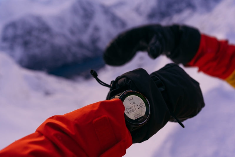
Have a safety back up
Antti uses the SuuntoPlus Safe - My Location feature on his watch. There is always a risk that something goes wrong and they need to call for help. This feature for Suunto 9 watches provides information that they can give to a rescue team. It provides location info and the direct distance and altitude from the starting place.
Antti also takes his smartphone with him as a backup in case he needs to reassess the route.
Watch Arctic Lines here!
All images by Jaakko Posti


