


SUUNTOブログ

Raising the stakes for Suunto World Vertical Week
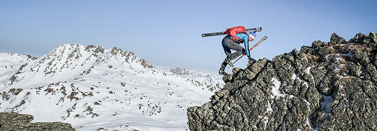
© Philipp Reiter
For us mere mortals, the Hoch Tirol ski route in the Austrian Alps usually takes six days of gut busting effort and every ounce of our endurance.
German ski mountaineer and trail runner Philipp Reiter and fellow runner and ski mountaineer Frenchman Francois D'haene aim to cover the 100 km and 10,000 m vertical gain in 24 hours starting this coming Monday. Both men enjoy a challenge.
“There’s a saying that it’s well known that something isn’t possible, and then someone comes along and just does it,” Philipp says. “You set a new limit and show that something once considered impossible is possible.”
To Philipp, this is what Suunto World Vertical Week is all about; taking on personal challenges. “For myself, when I have overcome a challenge like this, and I have other challenges not connected to sports, I understand if I just keep taking steps towards the goal I’ll eventually reach it.”
You can follow their adventure live and enjoy the beauty of the Austrian Alps; Philipp and Francois will be posting shots live from their adventure to our Instagram feed.
Click to find out about the Suunto World Vertical Week 2020 photo contest!
© Philipp Reiter
When Philipp isn’t out training in the hills, he works as a photographer for Salomon, capturing the action at big races in Europe. Over the last few years Francois noticed that he won all of the races when Philipp was at them working. “Eventually we decided to do something together, which is quite nice,” Philipp says.
Considered the queen of all ski routes, the Hoch Tirol route begins in Kasern in South Tyrol, and traverses Austria’s fourth highest mountain, Großvenediger (3657 m), and ultimately ends on the summit of the nation’s highest mountain, Großglockner (3798 m).
Philipp and Francois will start their journey around 9am on February 24, pushing hard to cover as much ground as possible before night falls and the going gets tougher. “The second stage will be the toughest,” Philipp says. “Navigation will be a challenge. It will be cold and we will be tired.”
Follow Philipp and Francois's adventure live here.
Lead images: © Philipp Reiter
Read more articles
This challenge will take you higher!
Must run routes around the globe!
Which nation runs the fastest? 10 fun facts from 2019.

This challenge will take you higher!
© Phillipp Reiter
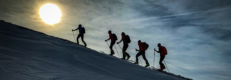
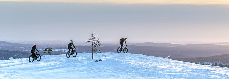
Believe it or not, there’s a hill or mountain somewhere that’s looking down at you laughing. It believes you’re a weakling. Do you have what it takes to shut it up?
That’s what Suunto’s annual World Vertical Week is about for the thousands of fans who participate each year. They find a nearby range, hill, or mountain that’s looking at them disrespectfully, and show that large mass of rock and earth who’s boss. As Sir Edmund Hillary famously suggested, there’s something satisfying about knocking the bastard off.
Seriously though, World Vertical Week is about the joy of a challenge, of sweating like a beast, and overcoming one’s resistance to fighting gravity to reach a summit. It’s an inexplicable human urge. All we know is we feel incredible after. To make it even more fun, we give you three incentives below to participate!
To participate in Suunto World Vertical Week 2020, open Suunto app and click the Vertical Week link in your inbox (the bell symbol on the top of your screen takes you to your inbox).
© Phillipp Reiter
New decade, new challenge
Starting on Sunday, February 23 and ending Sunday, March 1, this fifth edition of Suunto World Vertical Week also marks the first of a new decade. That’s why we want it to be the best ever.
For this reason we are sending out two special, optional challenges: climb 1000 m of vertical in one day during the week. Or, if that’s not possible, climb 1000 m over the whole week. That’s only a puny 150 m a day! Just imagine that arrogant hill sniggering if you fail!
Be in to win a Suunto watch
To give you extra incentive, we are running a photo contest on Instagram over the week, and will give away a Suunto 7 smartwatch or a Suunto 9 to three of the most inspiring photos that enter. All you need to do is share an image with a Suunto app data overlay and tag #verticalweek. We will decide the winners at the end of the week!
Click here to learn how to share your activities with Suunto app.
(Terms and conditions apply. Check them here.)
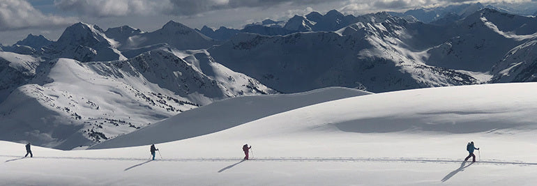
Rep your nation and sport
You can join the challenge on Suunto app, log all your efforts, and also compete for your nation and activity type. Last year, Italy came out on top for average ascents during the week. Spain also kicked ass; it came first in three divisions, and was also in the top five for four different activities. Will they continue to dominate?
To kickstart your competitive spirit, click here to see the results of last year’s Suunto World Vertical Week!
Lead images: © Phillipp Reiter
Read more articles!
Raising the stakes for Suunto World Vertical Week
7 tips to plan a route in the mountains
Which nation runs the fastest? 10 fun facts from 2019
10 ways to make your adventures more sustainble
How to find your way in the mountains.

10 ways to make your adventures more sustainable
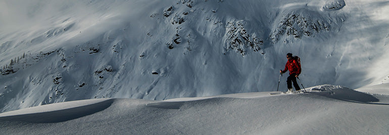
Greg charges his electric car onroute to the mountains. © Greg Hill
With the release of his latest film, Electric Greg, skimo legend and Suunto ambassador Greg Hill showed how the adventure lifestyle can be more sustainable. He climbed more than 100 mountains without using any fossil fuel, instead relying on his small electric car to get him into the mountains.
Also a weekday vegetarian who grows his own vegetables, Greg has researched how he can “be a little better'' in terms being kinder to the planet. He says it’s not about being perfect, but just trying to improve incrementally.
“As outdoor enthusiasts we are the ones who appreciate and get so much back from nature, so we should be the ones doing the most to preserve it,” Greg says. “Snowboarder Jeremy Jones is the ideal example of that. He recognized his impacts and looked for ways to change it. In creating Protect our Winters, he enabled change on so many levels, from personal to political. We can all make a difference.”
Follow the cardinal rule
Before even thinking about other ways to be more sustainable, make sure you are following the cardinal rule of outdoor recreation: pack it in, pack it out. “It’s a pretty simple mantra,” Greg says. The only thing you should leave in the outdoors are your footprints, and the only thing you should take are photos.
For a month, Greg restricted himself to cycling to and from all his trips © Greg Hill
Find backyard adventures
Often times, destinations further afield seem more exotic. While it’s great fun to explore far away places, exploring our local recreation areas helps us to feel more connected to the land where we live. It’s fun to get a topographical map of your local area, note points of interest, and visit them all. It’s also a fun adventure project to walk, hike, bike or run every single trail in your local mountain or forest park.
Move to the mountains
If working remotely is a possibility for you, consider moving somewhere closer to the mountains. “If you love adventure, find the ideal town and move there, and then backyard adventure forever,” Greg says. This will result in less travel time, therefore less carbon emissions. And every morning you will look out the window and see the mountains waitining for you!
Greg is a weekday vegetarian. Studies show eating less meat is good for the planet. © Angela Percival / Arcteryx
Use rail when possible
One of the great things about living in Europe is the rail network. Sure, you might need to factor in more time to get to and from the mountains, but using rail, rather than driving a fossil fuel powered car, definitely helps us to be a little better. And after a big day in the mountains you can sit back on the train and enjoy a well earned beer or coffee.
Buy quality gear
In this age of fast fashion and disposable culture, we are conditioned to shop for the best bargain. But the best bargain is often not the best deal. Some outdoor gear – like Suunto watches, for example – have been designed and built to last. It’s also possible to send our watches back for repair, extending their lifespan. Other gear, like these running shoes designed by Salomon, can be recycled and turned into ski boots.
Yes, good quality, durable, hardy gear usually comes with a higher price tag, but ultimately it will save you money in the long run because it will last longer and perform better. While cheap quality products wear out quickly and end up in landfill.
Maintain your gear
To help make your gear last, get professional advice about how to maintain it properly. When you get home from a big hike, for example, clean your footwear properly with the correct cleaner, and keep your leather boots waxed so the skin doesn’t dry out, potentially cracking. And wash your rain gear with washing detergent designed for the job.
Go electric
Buying an electric car is awesome, but if it isn’t possible for you then another option is to rent one when you do visit somewhere by plane. “On the last trip that I had to fly to, I landed and rented an electric car,” Greg says. “It was a Tesla Model X and it was amazing!” Remember, it’s not about being perfect, just a little better.
Reduce microfiber plastic pollution
One of the big challenges for the outdoor gear industry is reducing microfiber plastic pollution. All the plastic-based sport clothing people wear sheds trillions of microfiber plastics when they are washed, which ends up in the ocean. It’s estimated there are now more than one million trillion microfiber plastics in our oceans. That’s about 200 million microfibers for every person on the planet. Ouch.
You can help tackle this problem by choosing to use clothing made of natural materials, such as wool, or you can use a Guppyfriend Washing Bag to prevent microfibers going into the waterway when you wash your plastic-based outdoor clothing.
Choose ethical companies
“Buy from companies that have good ethical policy towards the environment and are pushing change at their corporate level,” Greg says. “Many companies are now working hard at being better.” Visit company websites and see what they are doing about sustainability. Suunto’s environmental policy is here.
Avoid packaging
Plastic packaging is a big problem for the planet’s ecosystems. It’s out of control. So, instead of buying flapjacks, for example, make your own. Take a reusable water bottle, reusable food containers, and do everything in your power to phase out packaging!
Lead images: © Angela Percival/ Arcteryx
Read more articles:
Fuelling the engine: talking nutrition with Greg Hill
Proving electric adventure is the future
How to find your way in the mountains
8 avalanche safety checks to tick off before the ski season


登山で道迷いを防ぐには?地図・コンパス・GPSウォッチを使ったナビゲーションの基本
登山やトレイルランニングでは、目的地に向かって進むだけでなく、「今どこにいるのか」「次にどちらへ進むのか」を常に把握することが大切です。
山では、分岐の見落とし、天候の変化、視界不良、スマートフォンの電池切れなどによって、思っていたルートから外れてしまうことがあります。よく整備された登山道でも、少しの油断が道迷いにつながることがあります。
道迷いを防ぐには、GPSやスマートフォンだけに頼るのではなく、地図、コンパス、地形を読む力、そしてオフラインマップやGPSウォッチを組み合わせて使うことが重要です。
この記事では、登山やトレイルランで道迷いを防ぐために知っておきたい、山のナビゲーションの基本を紹介します。
目次
登山で道迷いを防ぐには「現在地を把握する力」が大切
GPSだけに頼りすぎない
山で現在地を把握するための基本
地形図を読む練習をする
等高線を理解する
地図と実際の地形を照らし合わせる
コンパスの基本も身につけておく
GPSウォッチとオフラインマップを活用する
山でナビゲーション力を高める練習方法
Suuntoウォッチとコンパスで山のナビゲーションをサポート
まとめ|山では「現在地を知る力」とナビゲーションの準備が大切
登山で道迷いを防ぐには「現在地を把握する力」が大切
© Arc'teryx / Piotr Drozdz
山のナビゲーションで最も大切なのは、現在地を把握することです。
「いま自分がどこにいるのか」「どの尾根を歩いているのか」「次の分岐までどれくらいか」「周囲に見える山や谷は地図上のどこにあるのか」。こうした情報を意識しながら歩くことで、道を間違えたときにも早く気づきやすくなります。
現在地を把握する力は、単に地図上の一点を知ることだけではありません。周囲の地形、分岐、ピーク、沢、尾根、道の向きなどを観察しながら、「地図の情報」と「目の前の景色」を結びつける力です。
最初は難しく感じるかもしれませんが、歩きながら意識して確認する習慣をつけることで、少しずつ身についていきます。
GPSだけに頼りすぎない
GPSウォッチやスマートフォンの地図アプリは、登山やトレイルランニングでとても便利です。現在地、ルート、距離、標高、進行方向を手元で確認できるため、山での行動判断をサポートしてくれます。
一方で、デジタル機器だけに頼りすぎるのは避けたいところです。
スマートフォンの電池切れ、水濡れ、圏外、画面破損、操作ミスなどが起こる可能性があります。GPSウォッチも、バッテリー残量や設定、ルートデータの準備が不十分だと、必要なときにうまく使えないことがあります。
そのため、GPSやスマートフォンは便利なサポートツールとして活用しながら、地図やコンパスを読む基本も身につけておくことが大切です。
特にグループ登山では、ひとりだけがルートを把握している状態よりも、複数人が現在地や進行方向を理解している方が安心です。誰かに任せきりにするのではなく、自分でも「今どこにいるのか」を確認する意識を持ちましょう。
山で現在地を把握するための基本
現在地を把握するには、歩きながら周囲を観察する習慣が大切です。
チェックしたいポイントは以下です。
分岐や標識
尾根、谷、沢、ピーク
登り下りの変化
進行方向
歩いた時間と距離
周囲に見える山や建物
地図上の特徴的な地形
例えば、「次の分岐まであとどれくらいか」「今は登りなのか下りなのか」「地図上ではどの尾根を歩いているのか」を考えながら進むと、道を間違えたときに違和感に気づきやすくなります。
また、分岐を通過したら一度立ち止まり、標識や地図、GPSウォッチのルートを確認する習慣をつけるのもおすすめです。特に下山時は、疲れや安心感から分岐を見落としやすくなります。
「なんとなく進む」のではなく、現在地と次の目印を確認しながら歩くことが、道迷い防止につながります。
地形図を読む練習をする
© Arc'teryx / Piotr Drozdz
地形図は、登山やトレイルランニングでルートを理解するための基本です。
まずは、自分がよく知っている山や公園、ハイキングコースの地形図を見てみましょう。実際に歩いたことのある場所なら、地図上の道、ピーク、谷、川、建物などをイメージしやすくなります。
地形図を見るときは、いきなり難しいルートを読む必要はありません。まずは次のようなポイントを確認してみましょう。
登山道や分岐はどこにあるか
ピークや尾根はどこにあるか
谷や沢はどこにあるか
川や湖、建物などの目印はあるか
ルート全体で登り下りはどのくらいあるか
急な斜面やなだらかな場所はどこか
自宅で地図を眺めるだけでも、山の形をイメージする練習になります。実際に歩いたあとに地図を見返すと、「あの急登はここだったのか」「あの分岐はこの尾根の手前だったのか」と理解しやすくなります。
等高線を理解する
地形図で特に重要なのが、等高線です。
等高線は、同じ高さの地点を結んだ線で、山の形を読み取るための基本情報です。等高線の間隔が狭い場所は急斜面、広い場所は比較的なだらかな地形を示します。
等高線から読み取りたい代表的な地形は以下です。
地形
等高線の見え方
急斜面
等高線の間隔が狭い
なだらかな斜面
等高線の間隔が広い
ピーク
等高線が丸く閉じている
尾根
等高線が谷側へ張り出すように見える
谷・沢
等高線が山側へ食い込むように見える
鞍部
ピークとピークの間の低い部分
尾根、谷、ピーク、鞍部、急斜面などを等高線から読み取れるようになると、実際の地形を見たときに「地図上ではここにいるはず」と判断しやすくなります。
最初はすべてを正確に読む必要はありません。まずは、等高線の間隔を見て「急そうか、なだらかそうか」を予想することから始めてみましょう。
地図と実際の地形を照らし合わせる
地図を読む力は、家で眺めているだけでは身につきにくいものです。実際に山や公園、ハイキングコースで地図を見ながら歩くことで、地図上の情報と目の前の景色がつながっていきます。
練習するときは、まず安全でよく知っている場所を選びましょう。
練習方法
地図を北に合わせる
周囲の山、谷、川、道を確認する
地図上で現在地を推測する
分岐やピークごとに位置を確認する
歩いたルートを後から見返す
地図を北に合わせるとは、地図上の北と実際の北をそろえることです。コンパスを使うと、地図の向きと実際の地形を合わせやすくなります。
地図の向きが合っていると、目の前に見える尾根や谷、川、道の方向と、地図上の情報を照らし合わせやすくなります。
慣れてきたら、見晴らしの良い場所で周囲の山や谷を地図上で探してみるのもおすすめです。地図上のピーク、尾根、川、建物などを目の前の景色と結びつけることで、地形を読む感覚が少しずつ身についていきます。
コンパスの基本も身につけておく
登山やトレイルランニングでは、GPSウォッチやスマートフォンが便利ですが、コンパスの基本も知っておくと安心です。
コンパスは、進行方向や地図の向きを確認するための道具です。特に視界が悪いとき、分岐がわかりにくいとき、現在地と進行方向を確認したいときに役立ちます。
まず覚えておきたいのは、以下の3つです。
地図を北に合わせる
自分が進む方向を確認する
目印となる地形や方向を決める
コンパスを使うときは、地図とセットで考えることが大切です。コンパスだけを見て進むのではなく、地図上のルート、周囲の地形、現在地をあわせて確認します。
Suuntoには、登山やアウトドアで使いやすいコンパスもあります。GPSウォッチやスマートフォンと組み合わせて、アナログのナビゲーション手段を持っておくと、山での行動に安心感が生まれます。
▶︎Suuntoのコンパスを見る
GPSウォッチとオフラインマップを活用する
地図とコンパスの基本を身につけたうえで、GPSウォッチやオフラインマップを活用すると、山でのナビゲーションはさらに安心感が高まります。
対応するSuuntoウォッチでは、事前にルートを準備し、ウォッチ上でルートナビゲーションやオフラインマップを確認できます。スマートフォンを毎回取り出さなくても、手元で現在地や進行方向、ルートを確認しやすくなります。
GPXファイルを使ってルートを追加したい方は、Suuntoアプリのルートプランナーを使ってウォッチにルートを同期する方法も確認しておくと便利です。
▶︎関連記事:GPXルートをSuuntoウォッチに追加する方法|ルートプランナーを使った設定手順
登山やトレイルランでGPSウォッチを使うときは、出発前に以下を確認しておくのがおすすめです。
ルートデータを準備しているか
必要なエリアのオフラインマップを保存しているか
ウォッチのバッテリー残量は十分か
ナビゲーションやGPS設定を確認したか
スマートフォンや紙の地図などのバックアップを用意したか
GPSウォッチは、現在地やルートを手元で確認できる便利な道具です。ただし、あくまでナビゲーションをサポートするツールです。バッテリー残量、設定、地図データ、ルートの事前準備を確認し、紙の地図やコンパスなどのバックアップも用意しておきましょう。
ルート上の登り下りを事前に確認したい方は、Suuntoクライムガイダンスも便利です。
▶︎関連記事:登山・トレイルランのルートナビゲーション|Suuntoクライムガイダンスの便利な使い方
山でナビゲーション力を高める練習方法
山のナビゲーションは、知識として読むだけでなく、実際に使ってみることで身についていきます。
最初から難しい山域で練習する必要はありません。よく知っている山、公園、低山、ハイキングコースなど、安全に歩ける場所で少しずつ試してみましょう。
1. よく知っている場所の地図を見る
まずは、自分がよく歩く場所の地図を用意します。
地図上で、知っている道、分岐、建物、川、ピーク、広場などを探してみましょう。実際の景色を思い出しながら地図を見ることで、地図記号や等高線の意味が理解しやすくなります。
2. 歩いたルートを地図で振り返る
最近歩いた山やハイキングコースがあれば、どこを通ったか地図上でたどってみましょう。
登りがきつかった場所、下りが長かった場所、分岐で迷いそうになった場所を地図上で確認すると、実際の体験と地図の情報がつながります。
3. 現地で地図と地形を見比べる
安全な場所で、地図を北に合わせ、周囲の景色と照らし合わせてみましょう。
「見えている尾根は地図上のどこか」「この谷はどの方向に伸びているか」「次の分岐はどのくらい先か」を考えながら歩くと、現在地を把握する感覚が身につきやすくなります。
4. 見晴らしの良い場所で地形を読む
展望のある場所では、周囲の山、谷、川、街、建物などを地図上で探してみましょう。
地図と実際の景色を見比べることで、等高線や地形の理解が深まります。
5. 仲間と現在地を確認し合う
グループで歩く場合は、現在地や次の分岐を仲間と確認し合うのも良い練習になります。
「今どの尾根にいるか」「次はどちらへ進むか」「地図上ではどこにいるか」を声に出して共有することで、ひとりにナビゲーションを任せきりにせず、グループ全体の安心感にもつながります。
Suuntoウォッチとコンパスで山のナビゲーションをサポート
Suuntoは、登山、トレイルランニング、アドベンチャーなど、アウトドアで使えるナビゲーションツールを展開しています。
対応するSuuntoウォッチでは、GPS記録、ルートナビゲーション、オフラインマップ、標高、気圧、コンパス、日の出・日の入りなど、山での行動判断に役立つ情報を確認できます。
オフラインマップ対応ウォッチ
オフラインマップ対応のSuuntoウォッチは、登山やトレイルランニングで現在地や周辺地形を確認したい方に向いています。事前に必要な地図を保存しておくことで、スマートフォンの電波が不安定な場所でもウォッチ上で地図を確認しやすくなります。
▶︎オフラインマップ対応ウォッチはこちら
高度・気圧・コンパスをシンプルに確認したい方へ
Suunto Coreは、気圧計、高度計、コンパスを備えたアウトドアウォッチです。GPSやオフラインマップは搭載していませんが、天気や気圧、高度、方角をシンプルに確認したい方には選択肢になります。
▶︎Suunto Coreを見る
アナログコンパスもバックアップに
デジタル機器を活用する場合でも、紙の地図やアナログコンパスをバックアップとして持っておくと安心です。特に長時間の山行、電波が不安定な場所、天候が変わりやすい場所では、複数の確認手段を用意しておくことが大切です。
▶︎Suuntoのコンパスを見る
登山やトレイルで天気を確認する方法については、こちらの記事も参考にしてください。
▶︎関連記事:登山やトレイルで天気を確認する方法|Suuntoウォッチで気圧・日没・ストームアラームを活用
まとめ|山では「現在地を知る力」とナビゲーションの準備が大切
登山やトレイルランニングで道迷いを防ぐには、現在地を把握する力が大切です。
GPSウォッチやスマートフォンは便利なナビゲーションツールですが、それだけに頼りすぎず、地図、コンパス、地形を読む力も身につけておくと安心です。
まずは、よく知っている場所の地形図を見て、実際の景色と照らし合わせることから始めてみましょう。等高線、尾根、谷、ピーク、分岐などを少しずつ理解できるようになると、山での行動判断がしやすくなります。
対応するSuuntoウォッチのオフラインマップやルートナビゲーション、そしてコンパスや紙の地図を組み合わせながら、自分の現在地と進む方向を確認する習慣をつけていきましょう。
山をもっと安心して楽しむために、ナビゲーションの基本を日々の登山やトレイルランで少しずつ身につけてみてください。
▶︎Suuntoのアウトドア・登山ウォッチを見る

電動アドベンチャーこそ未来だと証明する
山へ向かう途中、電気自動車を充電する Greg。 © Greg Hill
記録を打ち立ててきたスキー登山家であり、Suunto アンバサダーでもある Greg Hill にとって、限界を押し広げること は特別なことではありません。2010年には1年間で 200万フィート(610,000m)を登り、2014年3月には標高差 100,000 フィートを滑走しました。そして今回、彼は化石燃料を一切使わずに 100 のピークを登り、山を愛する冒険者でありながら地球にも配慮できることを示しました。
「私は本当に環境を大切に思っていますし、言葉だけでなく行動でも示したいのです」と Greg は言います。「私たちは、自分たちが地球に与える影響にもっと意識的であるべきです。」
『Electric Greg』は今年の Banff Mountain Film Festival で初上映されました。ぜひ下の映像をご覧ください。街向けに設計された電気自動車で、Greg と仲間たちが険しいバックカントリーでその限界に挑む様子が描かれています。
Electric Greg は 12月3日 21:00 CET にオンライン公開されます。ぜひご注目ください。Greg と映画監督 Anthony Bonello によるライブチャットにも参加できます。
このプロジェクトのきっかけは何でしたか?
ずっと前から考えていたことでした。自然の中で活動する人間でありながら、そこへ行くために使っている乗り物が自然にとって良いものではない。その矛盾は、長いあいだずっと心の奥に引っかかっていました。
何が変わったのですか?
200万フィートプロジェクトを終えたとき、自分のカーボンフットプリントがとても大きかったことを痛感しました。大型トラックであちこち移動し、南米への旅もしていました。そこで 2012年4月に、その月はすべての冒険に自転車で向かい、ガソリンを一切使わないと決めました。とても楽しい1か月でした。11のピークを登り、素晴らしい旅になりました。ただ、かなり大変で、誰も一緒には来ませんでした。あまりに大変すぎて、簡単に賛同してもらえることではなかったのです。素晴らしい1か月でしたが、誰かに影響を与えることはできませんでした。
その後、2014年に雪崩で大けがをしました。何時間も、何日も、何か月もソファに座って回復しながら、自分に何ができるのか、どうすれば違いを生み出せるのかを考え続けました。そして 2016年、ついに電気自動車が市場に出始めました。技術がようやく整ったのです。私は 2016年にトラックを手放し、ヘリスキーもやめました。ようやく、トレイルヘッドまで移動し、少しでもより良い選択ができる技術が手に入ったのです。雪崩で大きな事故に遭ったことで、ようやく立ち止まり、子どもたちを見つめ、自分に何か影響力があるなら、もっと前向きな変化のために使うべきだと気づきました。
電動アドベンチャーは未来だと思いますか?
初登攀や縦走を追い求め、人間の限界に挑んできた探検者であることを誇りに思っていますが、それと同時に、このまったく新しい冒険のあり方を探る探検者でもあることが好きです。私はその可能性を押し広げていて、いつかそれが当たり前になってほしいと思っています。私は完璧ではありませんが、人間は進化する力を持っています。だからこそ、そこに知恵を使うべきです。そこには大きな感情的な報酬もあります。私たちは皆、強く立ち向かわなければなりません。
技術はとても速いペースで進化しています。バッテリーのリサイクル技術も、どんどん向上しています。これが未来です。来年3月には電動スノーモービルを手に入れる予定です。この小さな電気自動車で迎える冬は、これで3回目になりますが、さらに多くのトレイルヘッドへ向かえるのが本当に楽しみです。道路脇のトレイルヘッドだけを使う場合、アクセスできる範囲はどうしても限られます。スノーモービルがあればもっと奥まで入れますし、探検の楽しさも保てます。私の冒険の範囲はさらに広がっていくでしょう。もっと深く冒険する準備はできています。
あなたの電動シティカーについて教えてください。
航続距離はおよそ 150 km です。Jackson Hole まで運転したことがありますが、そこは 2,000 km 以上先ですし、カリフォルニアまで行ったこともあります。これまでの走行距離はもう 100,000 km 近くになります。これで旅に出ると、自然と少し笑顔になるんです。いわゆる “electric smile” と呼ばれるものですね。自分が少しでもより良い選択をし、カーボンフットプリントを減らすための方法を与えてくれました。
このプロジェクトで最も難しかったことは何ですか?
家族は、これによって自分たちの生活がどう変わるのかを心配していました。たとえば休暇で飛行機に乗らないことなどです。私はできるだけ家族の負担が少なくなるように努めていますが、家族もこの電動チャレンジに伴う課題を受け入れる必要がありました。スポンサーの中にも、当初は懐疑的な人たちがいました。変化には大きな不安がつきまとうものです。
世界を探検し、遠く離れた場所でスキーをしたりピークに立ったりする誘いも受けてきましたし、断らざるを得なかった旅も確かにたくさんありました。できるだけ良い選択をしようとはしていますが、時には飛行機に乗ることもあります。Utah のアスリートサミットに行ったときは、現地に着いてから電気自動車を借りました。少しでもより良い選択をするための方法は、いつでもあるのです。
メイン画像: © Bruno Long
関連記事:
北極で生まれた滑りへの情熱
暗い時間帯を走るための7つのヒント
冬のトレイルランニングのための7つのヒント
ランナーにとって冬が素晴らしい7つの理由

Welcome to Suunto Summit!
The fifth instalment of Suunto Summit, a celebration of our community and our collective passion for sport and the outdoors, will be held in January 2020 in Ylläs, in Finnish Lapland. We will start the weekend with a visit to Suunto factory and Suunto HQ in Vantaa and then travel by an overnight train to Ylläs, north of the Arctic Circle, to experience the beauty of northern Finland.
The participants for Suunto Summit 2020 are: Alberto from Spain, Alexandre from Brazil, Alpinefex from Germany, Dorn from USA, Lotta from Finland, Maja from Sweden, Majo from Philippines, Marie from UK, Matteo from Italy, Max from USA, Philipp from Germany, Sandra from Australia, Sawna from USA, Thumb K from Korea, and Xiaohua from China. Welcome to Suunto Summit!
Thank you to all who applied! We are humbled to have such a passionate community. It was very inspiring to hear your stories and to get to know you a little bit. Happy adventures and hope to meet you another time!Excitement at the 2018 Suunto Summit. Watch the event recap here


