


SUUNTOブログ


Justin Lewis takes over @suuntodive instagram
Underwater photographer and diver Justin Lewis is taking over the @suuntodive instagram for a week, starting today July 8th. Make sure to follow to see his incredible images and share his love for the ocean.
Tell us a little about yourself
Adventure and exploration are my passions. Growing up along the wild and beautiful coast of northern California, my family instilled in me strong values of conservation and respect for the natural world. I’ve been diving since I was eight and was certified at 12. On the water, in the water, beneath the water — free diving, scuba diving, surfing, ice diving, kayaking — water has been central to my life and my work. Through visual storytelling, I create rich, eye-catching content for national and international advertising agencies, editorial outlets, and conservation organizations.
Where do you dive?
I dive wherever my assignments take me, and I feel fortunate I have had the opportunity to dive in some incredible places around the world, including ice bergs in Greenland’s North Arctic, Fiji, the Maldives, Sipadan Island in Borneo, Tahiti and all over the Caribbean.
What inspires you in the underwater world?
I love working in unique underwater environments that provide a perspective rarely seen and often unexpected. For example, freshwater ecosystems and Mangrove forests. From an outside view you may not expect much is going on inside a mangrove forest, but once you get underwater the immense diversity and quantity of life is often staggering.
How would you describe your photography style?
I strive to create truthful imagery that moves the viewer and tells a powerful story.
What story do you wish to tell with your images?
Far too many stories. It seems like every day I think up a new project idea or am pitched a great potential story. Often the stories I feel motivated to work on, are the ones that require self-funding, and I can only do a handful of those each year. But if I could pick one to be funded it would be in the realm of marine conservation. Our oceans are changing at an unprecedented rate, and I am witnessing the changes first hand where I live on the Northern California coast.
Visit Justin’s website, Facebook and instagram for beautiful diving images and more information about his projects.


Sharks galore as Cristina Zenato takes over @suuntodive
Shark professional, cave diver, and PADI course director Cristina Zenato is taking over @suuntodive on Instagram for a week, beginning today. Make sure to follow to learn more about the world of sharks!© Victor Douieb
Tell us about yourself I am originally from Italy. I grew up in the African rainforest and I have lived the last 22 years in the Bahamas, where I follow my work and passion, which tend to blend into one activity. I am a shark professional and behaviourist; I specialize in human and sharks interactions. I’m also a cave diving instructor and active explorer and a PADI course director. I love to dive and share my diving through teaching it and through my images and presentations. My passion is my work, my work is my passion. Where do you dive? Primarily in the Bahamas, but I am always trying to find places where I can further my experience and knowledge about sharks and caves. I have been in many locations in the world to meet other people who work with sharks and learn more about cave, technical diving and exploration. Among them were Italy, England, Fiji, Rhode Island, California, South Africa, Mozambique, Dominican Republic, Cuba. What inspires you about the ocean? There are a lot of lessons to be learned from the underwater world and from nature in general. The most beautiful inspiration is in how everything seems to connect and flow together, in a perfect balance between beauty, life, death, darkness and light. The underwater world teaches a valuable lesson in the power of now and the power to accept all those around us and learn to coexist. Is there a story you wish to tell with your images? The story I wish to tell is the one of inspiration, I want people to see that dreams do come true, that if we listen and work where our hearts want to go we can get there. It's a story of communications with other animals, specifically with my sharks and one of acceptance and respect. It's a story of discoveries, of imagination, of a life rich of extraordinary mundane events. Visit Cristina’s website and Facebook page for incredible shark images.


Getting more from your Ambit than just basic stats
Coach to elite ultra runners Jason Koop says there’s more training insights we can get from our Ambits than most of us realise.© zooom.at/bergermarkus.com
When it comes to trail running, coach Jason Koop says gaining meaningful information demands more effort than required for cycling or road running. “Coach Koop” – as his athletes call him – has recently published a book called Training Essentials for Ultrarunning, which condenses the knowledge he’s amassed over his sixteen-year career. It’s received positive reviews and is a must on the bookshelf of every dedicated trail runner. He’s also the director of coaching at trainright.com and is a big fan of using cutting-edge technology like Suunto Ambits to achieve better training results.© zooom.at/bergermarkus.com
There’s more in there
Koop says many trail runners don’t know how to extract high value information from their “wrist-top computers”. It takes more effort and know-how than gaining high quality information for cycling and road running via power meters and pace.
“It’s the same type of information – how hard the workout was, what energy systems were tapped into, how much stress was put on the body, but the tools are different and with trail running it takes a few more steps to extract it,” Koop says.
© zooom.at/bergermarkus.com
Trail running makes it tricky
When it comes to cycling and road running this is easier, says Koop, because it’s simply a matter of calculating the time of a workout session with the power output for cycling or the pace for running. This simple formula makes it easy to score how hard and stressful a workout was.
“It’s not as easy with trail running because you have all these other factors like the trail surface and the elevation gain and loss so you can’t work it out as easily – it just takes a few more steps to extract meaning from the information,” Koop says. “A lot of trail runners are stuck at the information stage.”
© zooom.at/bergermarkus.com
Moving past the basic numbers
Numeric information such as distance, time, elevation gain and loss, pace and heart rate are interesting, Koop says, but in of themselves don’t offer the necessary insight to build and guide a systematic trail running training programme. Achieving this, he says, requires a “physiological tie-in”.
“There’s a big difference between just looking at the usual information your watch records versus using all of it to determine how hard the workout was, how much training stress was involved, and which energy systems were tapped into. That's the bridge that ultimately needs to be gapped – taking the statistical information and having an actual training tie in.”
© zooom.at/bergermarkus.com
Taking the next steps
There are two key steps to get past the information stage.
“Firstly, you need to normalise your pace so when you’re running a 10 minute per mile pace uphill you know what pace that equates to on the flats. Strava and Training Peaks have algorithms that do this for you. This gives you an apples to apples comparison for workouts that have different elevation gains. This first step sharpens the picture of the workout from a blurred mess to something where meaningful analysis can take place. It allows you to see how hard a workout was.
“The second step is to compartmentalise the aerobic stress a workout session generates, which is predominantly during the up hill and flat sections, from the muscular-skeletal stress predominantly generated in the downhill sections.
“If your normalized pace on the flats and uphills are getting better, your aerobic system is adapting. Similarly, if you are handling the total amount of descending or the rate of descending better, your muscular-skeletal system is adapting.”
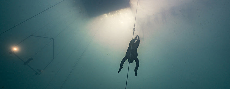

Watch this underwater drone footage of Will Trubridge diving deep
The X-Adventurer Freetracker is going to be a game changer for freediving.The X-Adventure Freetracker following William down. © Daan Verhoeven
When Suunto ambassador William Trubridge attempts to break his own freediving world record in July, an underwater drone will follow his dive.
He and his team tested the drone, called the X-Adventurer Freetracker, during Vertical Blue 2016 and hope at next year’s competition it will offer live video to audiences around the world.
It’s mounted on parallel tracks adjacent to the competition dive line, and descends and ascends with the diver, capturing the entire journey from the surface to the plate and back again.
See how long you can hold your breath as William dives!
“For this year we just got a proof of concept,” Will says, “but for next year’s Vertical Blue we hope to have it hooked up to a live internet feed, so people can watch from the other side of the world while an athlete grabs the tag at 120 m.”
“I think it’s going to be a real game changer for the sport because once people can tune in and be in their living room watching someone dive to 100 m as it happens, then that will really increase the spectatorship of the sport.”© Daan Verhoeven
Aside from making freediving more accessible to spectators, The X-Adventurer Freetracker will also improve safety. Never before have safety staff been able to see what’s happening for an athlete at depth before. If anything goes wrong, the safety crew will see it immediately via a live feed at the surface.
“It will definitely help with analysis of technique also,” Will says. “Because there's such a logistical difficulty in videographers going deeper than 40 m, a lot of freedivers have never seen what their technique looks like at depth from a good angle.”
William is attempting to break his current world record of 101 m this July and the X-Adventurer Freetracker will follow his journey into the depths.
Stay tuned!

How to use Suunto AIM-6 Thumb Compass
Mårten Boström says that the process of developing a new compass was an interesting one. “I have realized how much I as an elite orienteer can give insight to the product development team into how the product is actually used,” Boström says.
The team came up with an innovative design that supports three methods of direction finding. You can easily switch between methods, even during the same event, to match the challenges of your current terrain or the distance to the next control point.
With the AIM compasses it is possible to find and follow the direction in different ways. Which methods do you use and when?
On short legs I simply place the compass on the control leg and turn my body facing the next control to align the map meridians and needle north.
After I have picked a distinguishable object in the terrain to aim for I check which color/symbol -combination the north arrow is pointing to and aim for that same visual combination on every glimpse while proceeding towards the next control.
If I only need a course direction towards a big object (e.g. a lake) I might just use a whole sector in a similar manner.
On long legs I turn the compass capsule so I can see the north arrow fit in the orienting indicator – thus I don't need to keep the compass on top of the map on the rest of the leg.
In all of these I'm of course AIMing into the correct direction where the red arrow on the far end of the compass plate is.
The new Suunto AIM-6 can be used with a magnifying lens. When do you use that?
A loupe (or magnifying lens) is starting to be a popular accessory even for orienteers with good eyesight. There are more and more details on the maps nowadays and the loupe really helps.
Place the loupe in front of the thumb compass so that you can see the corner of the compass baseplate but mainly magnifying the map.
READ MORE
Learn more about the new AIM-6 and AIM-30 compasses
World champion’s 10 tips for orienteering
Meet the orienteer who runs a 2h 18m marathon


DEVELOPING A NEW ORIENTEERING COMPASS IS A TEAM EFFORT
Mårten, when did you start working on this project?
I have been involved in the development of Suunto's new orienteering compass line from the beginning of the year.
Product development is exciting as I have realized how much I as an elite orienteer can give insight to the product development team into how the product is actually used.
Mårten Boström worked closely with Suunto's compass business line manager Henrik Palin and designer Heikki Naulapää.
What did you want to change or improve?
As the compass is an orienteer's most precise aiding tool in navigating it's been an interesting task to refine the current compass to become an even better friend when out in the woods.
I wanted to redesign the needle in order to achieve a better contrast on to the map, make the needle much more stable while keeping it fast and take away some markings on the baseplate.
The graphics on the baseplate and the compass capsule were designed based on Mårten’s feedback.
Since the use of the compass needs to be swift I wanted to add color and symbol codes on the edge of the bezel so that there's no need to rotate the compass capsule. Using the colors and symbols one can simply memorize where the arrow is aiming and advance rapidly.
Our goal was to make the colors and symbols on the AIM distinguishable but easily memorable.
What are the key characteristics of a great compass?
A great compass should be easy to use and have a fast & stable needle.
How do you actually test a compass?
The compass is best tested in actual orienteering conditions out in the forest where temperatures vary from -10°C to +35°C and twigs hit your face while you are trying to navigate through unknown terrain over hills and through marshes!
Learn more about the new AIM-6 Thumb Compass
Learn more about the new AIM-30 Compass


