


SUUNTOブログ


Good times in the Himalaya for Ueli Steck
For the last two weeks, Suunto ambassador and alpinist Ueli Steck has been in Nepal acclimatizing to the higher altitude to prepare to climb the notoriously difficult south face of 7861 m Nuptse. After recently running up a 6000 m mountain there in his running shoes, it's clear things are going well so far for the Swiss Machine. Here's part two of our four part series on Ueli's Nuptse expedition.
Ueli climbing Lobuche Peak. © Ueli SteckAfter arriving in Nepal’s Khumbu Valley two weeks ago, Ueli Steck has been having a blast running, climbing, bouldering and camping out while acclimatizing to the higher altitude. He and his climbing partner Colin Haley are preparing to climb Nuptse, a 7861 m mountain only 2 km away from Everest. No one has successfully climbed Nuptse via its highly technical south face since Valeri Babanov and Yuri Koshelenko first did it in 2003.
Click here to read more about why Ueli wants to climb Nuptse via its difficult south face
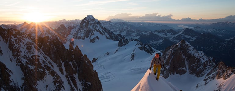
After completing his #82Summits project over summer, Ueli is "super motivated". © Ueli Steck
Ueli and Colin intend to climb it in the far more challenging alpine style, which means a one-time single push climb, without leaving fixed ropes. Ueli says he has acclimatized and is ready to climb. “Yesterday, I ran up Lobuche Peak from Dzongla,” he says. “It was pretty nice exercise. Summiting a 6000m peak in running shoes is quite fun!”
Click here to read about how Ueli has progressed as an alpinist
The view from Lobuche east where Ueli camped for two nights. © Ueli Steck
Ueli is waiting for Colin to get acclimated. The well known American climber experienced some altitude sickness and went down to Deboche village to recover. While he waits, Ueli has been having a good time in Dzongla. He also camped for two nights on Lobuche Peak. “It’s very nice to be back in the Khumbu Valley,” he says. “It’s great to see that life is going on for the Sherpas [after the earthquake]. “There are only a few tourists in the area so it’s quite calm.”
Stay tuned for the third part of our series on Ueli's Nuptse expedition: climbing Nuptse's south face

Ueli Steck to climb Nuptse in Nepal
Suunto ambassador Ueli Steck is soon heading to the Himalaya to climb Nuptse, a 7861 m monster in Nepal only 2 km from Everest. Follow our four-part series about Ueli and climbing partner Colin Haley’s journey as they acclimatize and make their one time push to the top.
After climbing 117, 000 vertical meters in the Alps this summer for his #82Summits project, Swiss alpinist Ueli Steck is “super motivated” to take on a grande mountain. In one week the Swiss Machine – famous for his lightning fast solo ascents – is travelling to Nepal to begin acclimatizing for an alpine-style attempt on Nuptse, via its formidable south face.
Click here to read more about Ueli Steck© Jon Griffith Ueli is drawn to Nuptse because the south face reminds him of the Grand Jorasses north face, one of the most famous walls in the Alps – a highly technical climb Ueli has done several times. But, while the Grand Jorasses north face towers 1200 m above the valley below, the south-face of Nuptse is 2500 m and 5 km wide. In 2003, Russian climbers Valeri Babanov and climbing partner Yuri Koshelenko made the first successful ascent of Nuptse via its south-face, using fixed ropes. For this they won the prestigious Piolets d'Or award. However, it came hard won – for Valeri the successful ascent followed three consecutive failed attempts in two years. Since Valeri’s ascent in 2003, no one has again summited Nuptse via the south-face. “It’s never been repeated because it’s a really hard route,” Ueli says. “It’s a really technical route. That’s why I want to go there –it’s another step for me in developing technical, high altitude climbing.”
© Jon GriffithUeli believes Nuptse will be more difficult than his famous 2013 solo ascent of Annapurna, one of the most dangerous mountains in the world. That climb won Ueli the Piolets d'Or award in 2014.“I think it’s definitely harder than Annapurna south face, technical wise,” he says. “The route I did on Annapurna looks insane, but technically it wasn’t hard.”Ueli is also motivated by the fact that no one has done a successful high altitude, technical climb in the Himalaya in the alpine-style.“The true alpine style means you don’t leave fixed ropes, you carry everything on one single ascent,” Ueli explains. “It’s a single push climb – you cannot go up part of the way, come down again and then go back up.”
Whereas Russian climber Valeri Babanov and partner used fixed ropes, Ueli and climbing partner Colin Haley won’t be. “It’s going to be interesting to repeat that route in more of an alpine style,” Ueli says. “Sometimes it’s really cool to realise what other people have climbed. “The fact that someone did it before, means I have much more knowledge, which means I can climb harder because of that knowledge. “I know Valeri very well and for me it’s an honour to repeat one of his routes.”Ueli and Colin will spend about two weeks acclimatizing to the higher altitude on the north face of 6440 m Cholatse. Ueli expects the ascent and descent of Nuptse to take between four and five days.
Stay tuned for the second instalment in our four part series. Part 2: acclimatizing.
Main image credit: © Jon Griffith


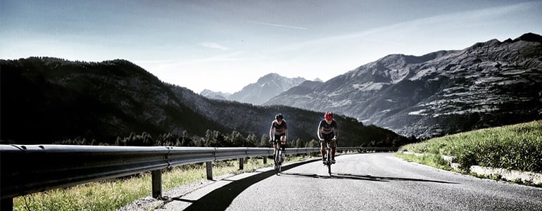
Take a ride around Mont Blanc
Mont Blanc is the highest mountain in the Alps and cycling around it offers mind-blowing views. Press play on the video below and experience what it's like to ride through this incredible landscape!
Alpinists and ice climbers Matthias Scherer and Tanja Schmitt can’t get enough of the mountains. Whether, it’s winter or summer, their lives revolve around preparing for and going on big adventures. To help them physically and mentally prepare for the coming winter, they cycled around Mont Blanc in less than 24 hours. Below, Tanja Schmitt recounts their big day out pedalling.
By Tanja Schmitt
The Tour du Mont Blanc climbs more than 8050 vertical meters over a total distance of 340 km. The route goes through some of the most beautiful alpine passes in the Alps and some of the most spectacular parts of Italy, Switzerland and France. It offers stunning views of the snow-covered flanks of the mighty Mont Blanc (4810m), the highest peak in the Alps.
As mountaineers and ice climbers, the psychological part of our sport has a big impact and the physical demands are also high. Next to basic strength training, regular rock-climbing and dry tooling, endurance training plays a major role in our overall training. For this reason, over summer Matthias and I do a lot of vertical ascent training through mountain running and biking. The idea of cycling non-stop around Mont Blanc was born from the logical step of connecting the passes and roads we’ve gotten to know so well through our training and traveling over the years. And on Sunday, August 30th the time had finally come to take action.
Click here to read more about Matthias Scherer and Tanja Schmitt
With bright headlamps and equipped with several Clif Shot Gels, Clif Shot Bloks and Clif Bars, together with salt-tablets and water, we hit the road at Aymaville and cycled along the empty roads of Aosta towards Grand St. Bernard. Our heartbeat was regular and we cycled in a steady rhythm. Our route lead us from the Col du Gr. St.Bernard over Champex to Martigny. Then over the Col de la Forclaz and on to Chamonix, Le Fayet and St. Gervais to Megève. From there we gained 750 vertical meters to les Saisies and further on to Beaufort. Temperatures during the day went to over 30° C and, correspondingly, the cycling became tougher. On the Cormet de Roselend, I began to suffer from the heat due to an agitating dry cough. But as the evening freshness came on, we got our strength back and enjoyed rolling down the long descent to Bourge-St-Maurice.
The challenge to organize water refills became an unexpected issue. However, after a nerve-racking 30-minute wait in the queue of a nearby McDonalds, we rehydrated and furthermore equipped ourselves with an ice-filled cola! The last verticals up the road of Petit St-Bernard were tackled at dawn. Then the end was in sight and after a spectacular ride down the Col to Prè-St-Didier, we felt like we were flying on the last flat kilometers on the SS26 to Aymaville. On arriving back in Aymaville, our Suunto Ambits showed a time of 19h55min. A wonderful training day in the mountains had come to an end.

24h cycle tour around Mont Blanc
It’s 7000 m of elevation gain and 300 km and ice climbers and alpinists Matthias Scherer and partner Tanja Schmitt aim to cover their Tour Mont Blanc in less than 24 hours.
It’s the highest mountain in the Alps and cycling around the base of Mont Blanc takes most people around five days. Matthias Scherer and Tanja Schmitt aim cycle it on racing bikes in less than 24 hours this Sunday.
© Matthias Scherer
They’ve been climbing mountains and frozen waterfalls for over 15 years together and for them Mont Blanc – with its stunning ice channels and snow covered flanks – is a symbol of their shared passion.“Mont Blanc for me is something like a church,” Matthias says. “When I see it, it reminds me there’s something higher and more important in life to long for than numbers and training.”The unsupported tour will be the ultimate test of their bodies and minds before autumn arrives and their ice-climbing season begins. The most challenging part, however, will be staying focused and fueled.“You have to be extremely concentrated the whole time,” Matthias says. “The descents are very tricky, the roads aren’t always good, as they have holes. “You have to stay fueled if you want to keep a rhythm.”
© Matthias Scherer
They’ll be drinking water every 10 minutes, taking electrolytes every 13 minutes, eating energy blocks every 20 minutes and sandwiches before each long downhill to allow enough rest time for digestion. Another challenge is making sure they don’t push too hard too early on in the tour. “At the beginning of a big tour like this it’s common to be a little bit euphoric and to push too hard,” Matthias explains. To avoid this, they will use their Ambit3 Peak watches to ensure they keep their heart rates at 70 per cent of their maximum. They’ll also use their watches to record their elevation gain and for GPS tracking to navigate the few stages of the tour they’re less familiar with.“It’s going to be a long training day for us, but I don’t expect to be broken,” Matthias says. “I plan to go climbing right away on Monday.”

How were the 82 summits, Ueli Steck?
How many of 82 peaks had you climbed before?
Not sure, but not too many. I had never climbed the easier mountains before.
Climbing Les Droites. © Ueli SteckWhat did the #82Summits project teach you?
That it’s all about motivation. I was surprised how long I could keep going without stopping or having rest days. It’s different to an expedition because I was moving almost everyday. That was great. I was so motivated that even on rest days I went for a run!
What three words would you use to describe #82summits?
Passion. Friendship. Fun.
What were some of the most unforgettable moments of the summer?
There were many great moments. The last one was on Barre des Écrins, in the French Alps. I ran up the wrong valley in the morning. Instead of taking the trail to Glacier Blanc, I went to Glacier Noir. There was a sign I read and I was sure the trail to Glacier Blanc was on the left. It felt strange, but I kept going. I ran for another two hours before reaching the end of the valley. By then it was daylight and I realized I wasn’t where I should be. I checked Google Maps and figured out I was on the wrong side on the mountain. I ran back down and after 3h40 minutes I was back in the valley from where I started my ascent again. So I did a little extra to warm up!
Ueli and wife Nicole on Fiescherhorn. © Ueli Steck
When was the project at its hardest?
Mentally, it was the hardest in the beginning. You start and there are still so many peaks to climb!
You started the project with Michi Wohlleben, but didn’t finish with him. What happened?
Michi crashed his paraglider descending from the Schreckhorn Hut in Switzerland. Afterwards he tried his best, but couldn’t continue.
Aiguille Blanche de Peuterey. © Ueli Steck
How did losing your partner early on change things?
It was a difficult moment. What could I do? I didn’t want to give up so easily. That’s not my personality. I would never forgive myself. So I kept going and it turned out great. It was so much fun to climb with different partners and to do solo climbs. I still have very great memories of climbing with Andreas Steindel, a mountain guide and member of the Swiss Ski Mountaineering Team. Climbing with my best friend and supporter Daniel Mader and, of course, also the summits I climbed with my wife, were all great experiences. I also enjoyed solo climbing some peaks.
How were the cycling stages of the project?
This was something new to me. On the last part down from Massif des Écrins, I really felt the magic of cycling. Going over Col du Galibier, an iconic section on the Tour de France, is a great memory. And after so many kilometres your butt doesn’t hurt anymore!
A rainy day didn't stop Ueli having fun cycling over Col du Galibier. © Ueli Steck
If you had to choose, what were some of your favourite peaks?
1. Red Pillar of Brouillard, on the Brouillard flank of Mont Blanc, in Italy
2. Dent du Geant-Grandes Jorasses Traverse: multiple 4000 m peaks on the border between France and Italy
3. Monte Rosa Traverse: 18 peaks in one day
4. Finsteraarhorn, Switzerland with my wife
5. Aiguille blanche de Peuterey, Mont Blanc massif, Italy with Jonathan Griffith
In some of your Facebook posts you refer to the pioneers who did the first ascents on these peaks. Was there a historical side to your project as well?
It was great to be on all of these routes. Sometimes you think about the people who did the first ascents and you realize that what these guys achieved was just incredible!

トレーニングで強くなるのは休んでいるとき|回復と適応の仕組み
トレーニングで強くなるには、走る、登る、泳ぐといった運動そのものが欠かせません。しかし、身体がトレーニングの刺激を受け止め、次の負荷に対応できるよう変化していくのは、運動を終えたあとの時間です。
つまり、休息はトレーニングの反対ではなく、その一部です。負荷と回復が適切に組み合わさって初めて、持久力や筋力、動作の効率といった能力の向上につながります。
この記事では、スポーツウォッチで回復をどう測るかではなく、回復中の身体で何が起きているのかを中心に解説します。
目次
身体は一定の状態を保とうとする
「疲労が抜けること」と「適応」は同じではない
睡眠は適応を支える土台
自律神経の変化は回復を知る手がかりになる
データが良くても休むべき日はある
回復を「判定」ではなく「判断材料」として使う
日々の変化を、現在のSuuntoで振り返る
まとめ|休息まで含めてトレーニングを設計する
身体は一定の状態を保とうとする
人の身体には、体温や血糖値など、体内の環境を一定の範囲に保とうとする働きがあります。これはホメオスタシス(恒常性)と呼ばれます。
トレーニングは、この安定した状態へ意図的に刺激を与える行為です。運動中はエネルギーを消費し、筋肉や心肺機能、自律神経系に負荷がかかります。身体はその刺激から回復する過程で、同じような負荷へ以前より対応しやすくなるよう適応を進めます。
ただし、刺激が強ければ強いほど効果が高まるわけではありません。回復できる範囲を超えて負荷が続けば、質の高い練習を積み重ねにくくなります。
「疲労が抜けること」と「適応」は同じではない
回復という言葉からは、筋肉痛がなくなる、疲労感が軽くなるといった変化を想像しがちです。しかし、身体が元の状態へ戻ることと、トレーニング刺激に適応することは、厳密には同じではありません。
エネルギーの補充、損傷した組織の修復、神経系の落ち着き、運動動作の学習などは、それぞれ異なる時間軸で進みます。朝の数値が良好でも脚に強い張りが残ることがあり、反対に身体は軽く感じても、睡眠不足によって集中力が落ちている場合があります。
回復を一つの数字で表し切れないのは、このように複数の仕組みが同時に関わっているためです。
睡眠は適応を支える土台
睡眠は、身体と脳が日中の刺激から回復するための重要な時間です。トレーニングだけでなく、仕事、移動、暑さ、精神的な緊張なども身体にとってはストレスになります。運動量だけを見ていても、実際の回復状態を捉えられないことがあります。
睡眠を振り返るときは、一晩の長さだけでなく、就寝・起床時刻の規則性、夜間の目覚め、起床時の感覚、日中の眠気にも目を向けましょう。完璧な睡眠を一晩だけ目指すより、無理なく続けられる生活リズムを整えることが大切です。
自律神経の変化は回復を知る手がかりになる
心拍数やHRV(心拍変動)は、自律神経の状態を間接的に捉える手がかりです。睡眠中の変化を継続して見ると、普段の自分と比べて身体が落ち着いているか、ストレスの影響が残っているかを考える材料になります。
大切なのは、他人の値や一般的な基準と競うのではなく、自分自身の通常範囲からの変化を見ることです。また、単日の上下だけで結論を出さず、睡眠や主観的な疲労と合わせて傾向を確認します。
▶︎関連記事:「HRVとは?心拍変動を理解してトレーニングの回復を最適化する方法」
データが良くても休むべき日はある
自律神経に基づく指標は便利ですが、筋肉や腱、関節の局所的な負担、感染症、栄養不足など、すべての状態を検出できるわけではありません。ウォッチの数値が通常どおりでも、強い筋肉痛や痛み、発熱、息苦しさがあれば、数値を優先して運動を続けるべきではありません。
回復を判断するときは、データに加えて次のような感覚も確認します。
起床時に疲労が残っていないか
筋肉や関節に普段とは異なる痛みがないか
食欲や気分が普段どおりか
ウォームアップで身体がいつものように動くか
練習に集中できる状態か
回復を「判定」ではなく「判断材料」として使う
回復データの目的は、その日のトレーニングを自動的に決めてもらうことではありません。予定していた練習と現在の状態を照らし合わせ、負荷を調整するための判断材料として使うことに価値があります。
状態が安定していれば予定どおり取り組み、疲労の兆候が重なっていれば、強度を下げる、時間を短くする、軽い運動へ切り替える、休養日にするといった選択ができます。こうした小さな調整は、長期的にトレーニングを継続する助けになります。
▶︎関連記事:「Suuntoでリカバリーを確認する4つの方法」
▶︎関連記事:「ランニングのトレーニング負荷を管理する方法」
日々の変化を、現在のSuuntoで振り返る
元記事で紹介されていた旧世代ウォッチの単発テストに代わり、現在は睡眠、HRV、心拍数、トレーニング負荷などを継続して振り返る考え方が中心です。Suunto Race 2、Suunto Race S、Suunto Run、Suunto Vertical 2などの現行モデルとSuuntoアプリを活用すれば、トレーニングと日常生活の変化を長期的な傾向として確認できます。
大切なのは、その日の数値だけで良し悪しを決めるのではなく、自分の通常状態を知り、負荷や生活習慣との関係を振り返ることです。具体的な確認方法は、上記の関連記事で詳しく紹介しています。
まとめ|休息まで含めてトレーニングを設計する
身体は、トレーニングの刺激を受けたあと、休息中に修復と適応を進めます。だからこそ、負荷をかける日だけでなく、回復する時間まで含めてトレーニングを考える必要があります。
一つの数値だけで「回復した」と判断するのではなく、睡眠、自律神経の傾向、筋肉や関節の状態、気分、実際に動いたときの感覚を組み合わせましょう。自分の通常状態を知り、その変化に合わせて負荷を調整することが、継続的な成長につながります。
トレーニングと回復を、一つの流れとして振り返る
SuuntoのスポーツウォッチとSuuntoアプリで、睡眠、HRV、心拍数、トレーニング負荷の傾向を確認し、自分に合ったトレーニングリズムを見つけましょう。
Suuntoウォッチを見る


