


SUUNTOブログ

On the rise: top stories from World Vertical Week 2020
© Philipp Reiter
World Vertical Week has become an annual tradition, and many Suunto users are finding creative ways to get the most out of it.
The week is really an invitation to get outside, to push oneself, and find new resolve and strength. It’s also a chance to show that nearby hill or mountain who’s boss.
This year, we again ran a World Vertical Week photo competition with three lucky people winning a Suunto 7 or a Suunto 9. We asked our Instagram followers to share an image with a Suunto app data overlay from one of their ascents over the week and tag #verticalweek. We received so many inspiring entries. Thanks to everyone who participated. Check out the winners and their shots below. Congrats!
Firemen to the rescue!
Two firemen in Finland went above and beyond the call of duty for World Vertical Week. Henri-Aleksi Pietilainen, 29, and his room mate at the Rescue Academy showed their dedication by donning their protective fire gear and ascended the most popular training hill in Helsinki multiple times – and just after finishing a 24 hour shift. Respect guys!
“We thought it was going to be easier (considering my level of training in the mountains and my friend’s latest expedition through Greenland), but the extra 25 kg of weight and unforgettable clothing and gear gave a nice extra ‘touch’ and was really good training,” Henri says. “We did this in a pair because in real firefighting rescue missions it’s good to have a partner to help each other out.”
Cooking up a storm
It was Lukasz Bodaszewski’s first time participating in World Vertical Week. The 39-year old chef from Poland runs a catering company with his wife in the French Alps. He aimed to ascend 3000 m over the week, and managed 2300
“But I finished 1000 m in one day and I’m proud of that,” he says. “Vertical Week was good timing because I’m training for the 160 km Val d’Aran UTMB in the Pyrenees and for 145 km TDS at UTMB this year, so it was good to have a specific climbing week.”
Getting out there
Casey Sackett didn’t hold back for World Vertical Week. From Hurricane, Utah, Casey aimed to achieve a mile of vertical gain (1610 m) over the week. He notched up a total of 1631 over a series of awesome trips, including mountain biking the Gooseberry Mesa and the rest what he refers to as “desert alpinism” (alpine style lines in a desert ecosystem).
“Conditions were perfect all week out here and gave me the opportunity to get out every chance I had!” Casey says. “My favorite push was my last one, trekking/trail running up a mesa to the La Verkin Overlook. My eight-year-old daughter set the pace on the 4 km ascent with almost 243 m of gain. We did it in just 61 minutes! Her endurance blew me away, so proud!”
Thanks again to everyone who got out there and pushed their comfortzone for World Vertical Week. Keep it up!
Lead images: © Philipp Reiter
Read more articles
The nation that climbed the most in World Vertical Week is ...
7 tips to accelerating your vertical speed
How to find your way in the mountains
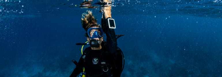

Dive Doctor's Orders
Spring into action slowly but surely after a longer break between dives. Photo by Alex Kydd.
Partial as I am to pies, chips, peas and as many garishly colored fatty sauces as I can cram in, there comes a time when the wetsuit constricts the internal organs so much that radical action is called for. With the new diving season nearly upon us, it’s an opportune moment to review the best ways to trim down and ease those rusty diving muscles back into action.
Ease those rusty diving muscles back into action. Photo by Alex Kydd.
Improve fitness
Get in shape with some cardiovascular exercise, eg. running, swimming or cycling (as well as getting the ticker pumping, this will help develop flexibility, tone and strength in the core muscles of the back, abdomen and legs).
Stay hydrated
Keep those fluids up, particularly if you’ve had alcohol in the 24 hours before diving. It takes a few days to really get hydrated so stay on top of your water intake.
Easy start
Short, shallow, and in calm conditions are the only way to get back into the water after a pause. Diving is more fun when it is safer, and careful preparation, visualizations and warm up dives are good practice.
Stop smoking
No other action will have a more positive effect on your gas consumption, bottom times and overall health.
Lose weight
A lighter, more hydrodynamic physique will benefit you before, during and after dives.
Service kit
Regulators and demand valves in particular. Ensure your BCD/dry suit is working properly, your computer has sufficient battery power and the rest of your kit is in good condition – preferably before you get to the dive site!
Test dives
Try out any new equipment in a pool/sheltered area to get used to it. This goes for recently serviced kit too, have a few dives and be sure you are ready togo diving.
|mportant O2
Ensure you have access to oxygen in case of emergency, and make sure you have enough to last. Everyone should know where the oxygen is stowed whilst you are diving, if you aren’t sure then make it your business to find out.
Be prepared
Keep the details of your nearest chamber/helpline to hand, and if in any doubt, call them earlier rather than later,
Photo by Alex Kydd.
And remember, some basic but often overlooked ways of minimizing your inert gas burden and decompression stress:
Plan the Dive, Dive the Plan
Stay well within your planned dive parameters – your computer has an algorithm but has no idea of how tired/unfit/hungover you are, so don’t push its limits
Slowly does it
Keep your ascent rate controlled – watch your buoyancy, particularly in the shallow part of the water column.
Safety chill
Incorporate safety stops and pad them out if you have spare gas to do so, especially when you’ve been diving deep, strenuously, or in cold water. Imagine all the wonderful encounters you may experience if you hangout out a little bit longer underwater.
Post dive chill
Avoid doing any hard exercise for several hours after the dive (this includes lugging all your kit up hill) – bubbles are liberated from off-gassing tissues for some time after you’ve surfaced, and the less they are agitated the better.
Multi day chill
If you’re diving on multiple occasions over several consecutive days, try to insert a dive-free day every 2-3 days to allow your tissues to desaturate completely.
Stay down
Don’t go to altitude sooner than is recommended – generally 24 hours from completing your last dive.
Photo by Alex Kydd.
It’s worth emphasizing that in spite of doing everything correctly, and following all the established preventative strategies outlined above, divers still get bent for no apparent reason. There’s no justice in this world, and life is inherently unfair.
So make the call, ask for advice, alert someone, even if you feel you can’t possibly have DCI - any symptom that wasn’t present before the dive should be assumed to be DCI until proven otherwise.
About Dr Oli
Dr Oli, Hyperdive.co.uk, much like the surface of our blue dot planet Earth, is approximately 60-70% water. He constantly strives to put much of the other 30-40% to good use in the field of diving medicine.
Serving as the Medical Director and Senior Hyperbaric Physician at London Diving Chamber, UK for 13 years, this post at one of the busiest hyperbaric chambers in the UK has given him extensive experience in the assessment and management of all types of diving accidents and emergencies. In addition he has gained a thorough knowledge of the practice of hyperbaric medicine, for non-diving conditions.
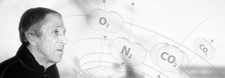

Tribute to Dr Bruce Wienke
It is with great sadness that we announce the news that our beloved Dr Bruce Wienke, a true pioneer in his field of dive specific algorithm design, has passed away leaving behind a great legacy.
A keen diver, and downhill skier, Dr Wienke’s interest in diving was reflected in his achievements, and great success as seen in his accolades. His astonishing CV included Instructor Trainer and Technical Instructor with NAUI, a Master Instructor with PADI, Institute Director for YMCA, and an Instructor Trainer/Technical Instructor for SDI/TDI.
“Most of the diving I have done has always been interesting and exciting. To my Australian friends, diving the Great Barrier Reef was incredible. Another favourite place is diving underneath the Arctic ice. It is just amazing; the water is cold of course, but it is just amazing. It is so clear, and perhaps because of the overhead ice and the associated underwater activity it’s like diving in a three dimensional surrealistic world. It is fantastic, and contrary to what you might think there is a variety of life down there. Very cool.” Dr Bruce Wienke.
Dr Wienke joined Suunto in the late 90’s, where he hit the ground running and didn’t stop. The collaboration arose after some of his diving work published on core screen modelling in the open literature and was noticed by Ari Nikkola who was at the time presiding over the inhouse the algorithm development at Suunto.
Employing his great expertise in the diving specific algorithm field, he joined Ari Nikkola in the development of the revolutionary Reduced Gradient Bubble Model (RGBM).
The RGBM, a name first coined by Dr Wienke, is a dual phase approach to staging diver ascents over an extended range of diving applications (altitude, nonstop, decompression, multiday, repetitive, multilevel, mixed gas, and saturation) and a giant stride forward from previous modified Haldanean decompression models.
Prior to joining the Suunto family, Dr Wienke was a Program Manager in the Nuclear Weapons Technology Simulation and Computing Office at the Los Alamos National Laboratory (LANL) where he completed research up until his death. As head of the LANL Nuclear Counter Measures Dive Team involving Special Warfare Units both above and below the water, he trained alongside the special forces well into his 70s.
His interests were in computational decompression models, gas transport, and phase mechanics. He was the author of five monographs on his field, as well as more than 200 technical journal articles and was an active contributor to underwater symposia, educational publications, technical periodicals and decompression workshops.
Alongside his high achieving work life, he served actively as a consultant for decompression algorithms within the dive industry and he worked with Divers Alert Network, DAN, on applications of high performance computing and communications for diving.
Wienke’s first Suunto dive computer releases were the Vyper and Cobra in 1999, which is still accompanying divers all over the world on their underwater adventures, shortly followed by the iconic, best-selling Suunto Stinger dive computer. With his continued support, Suunto together with Dr Wienke, using his own source code, created the Technical RGBM. Now including helium gas, and rated to a depth of 120m, the Suunto HelO2 and D9tx opened the door to the technical dive market. A major new release in 2012 from Dr Wienke saw the Suunto Fused RGBM which combined the Full RGBM and the Technical model. Greatly benefiting both the recreational and technical diver, the algorithm now supported rebreathers, and new depths were conquered with a 150m rating. The Suunto Fused™ RGBM 2 can be found in the latest releases, the Suunto Eon Series and the D5. The algorithm manages dissolved gas and free-gas in both the tissues and blood of a diver making it significantly smarter than any previous models. Dr Wienke described this algorithm as a supermodel.
Dr Bruce Wienke was a widely regarded and respected figure of the dive industry, and he will be by missed all his Suunto family. He died on Saturday 15th February 2020, and is survived by his wife, Annie.

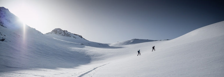
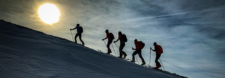
Raising the stakes for Suunto World Vertical Week
© Philipp Reiter
For us mere mortals, the Hoch Tirol ski route in the Austrian Alps usually takes six days of gut busting effort and every ounce of our endurance.
German ski mountaineer and trail runner Philipp Reiter and fellow runner and ski mountaineer Frenchman Francois D'haene aim to cover the 100 km and 10,000 m vertical gain in 24 hours starting this coming Monday. Both men enjoy a challenge.
“There’s a saying that it’s well known that something isn’t possible, and then someone comes along and just does it,” Philipp says. “You set a new limit and show that something once considered impossible is possible.”
To Philipp, this is what Suunto World Vertical Week is all about; taking on personal challenges. “For myself, when I have overcome a challenge like this, and I have other challenges not connected to sports, I understand if I just keep taking steps towards the goal I’ll eventually reach it.”
You can follow their adventure live and enjoy the beauty of the Austrian Alps; Philipp and Francois will be posting shots live from their adventure to our Instagram feed.
Click to find out about the Suunto World Vertical Week 2020 photo contest!
© Philipp Reiter
When Philipp isn’t out training in the hills, he works as a photographer for Salomon, capturing the action at big races in Europe. Over the last few years Francois noticed that he won all of the races when Philipp was at them working. “Eventually we decided to do something together, which is quite nice,” Philipp says.
Considered the queen of all ski routes, the Hoch Tirol route begins in Kasern in South Tyrol, and traverses Austria’s fourth highest mountain, Großvenediger (3657 m), and ultimately ends on the summit of the nation’s highest mountain, Großglockner (3798 m).
Philipp and Francois will start their journey around 9am on February 24, pushing hard to cover as much ground as possible before night falls and the going gets tougher. “The second stage will be the toughest,” Philipp says. “Navigation will be a challenge. It will be cold and we will be tired.”
Follow Philipp and Francois's adventure live here.
Lead images: © Philipp Reiter
Read more articles
This challenge will take you higher!
Must run routes around the globe!
Which nation runs the fastest? 10 fun facts from 2019.

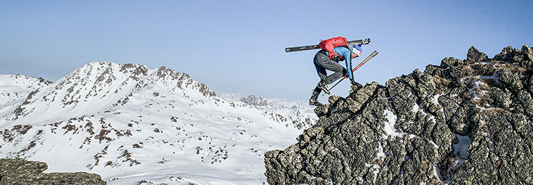
This challenge will take you higher!
© Phillipp Reiter
Believe it or not, there’s a hill or mountain somewhere that’s looking down at you laughing. It believes you’re a weakling. Do you have what it takes to shut it up?
That’s what Suunto’s annual World Vertical Week is about for the thousands of fans who participate each year. They find a nearby range, hill, or mountain that’s looking at them disrespectfully, and show that large mass of rock and earth who’s boss. As Sir Edmund Hillary famously suggested, there’s something satisfying about knocking the bastard off.
Seriously though, World Vertical Week is about the joy of a challenge, of sweating like a beast, and overcoming one’s resistance to fighting gravity to reach a summit. It’s an inexplicable human urge. All we know is we feel incredible after. To make it even more fun, we give you three incentives below to participate!
To participate in Suunto World Vertical Week 2020, open Suunto app and click the Vertical Week link in your inbox (the bell symbol on the top of your screen takes you to your inbox).
© Phillipp Reiter
New decade, new challenge
Starting on Sunday, February 23 and ending Sunday, March 1, this fifth edition of Suunto World Vertical Week also marks the first of a new decade. That’s why we want it to be the best ever.
For this reason we are sending out two special, optional challenges: climb 1000 m of vertical in one day during the week. Or, if that’s not possible, climb 1000 m over the whole week. That’s only a puny 150 m a day! Just imagine that arrogant hill sniggering if you fail!
Be in to win a Suunto watch
To give you extra incentive, we are running a photo contest on Instagram over the week, and will give away a Suunto 7 smartwatch or a Suunto 9 to three of the most inspiring photos that enter. All you need to do is share an image with a Suunto app data overlay and tag #verticalweek. We will decide the winners at the end of the week!
Click here to learn how to share your activities with Suunto app.
(Terms and conditions apply. Check them here.)
Rep your nation and sport
You can join the challenge on Suunto app, log all your efforts, and also compete for your nation and activity type. Last year, Italy came out on top for average ascents during the week. Spain also kicked ass; it came first in three divisions, and was also in the top five for four different activities. Will they continue to dominate?
To kickstart your competitive spirit, click here to see the results of last year’s Suunto World Vertical Week!
Lead images: © Phillipp Reiter
Read more articles!
Raising the stakes for Suunto World Vertical Week
7 tips to plan a route in the mountains
Which nation runs the fastest? 10 fun facts from 2019
10 ways to make your adventures more sustainble
How to find your way in the mountains.
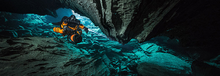

Watch this masterpiece and feel the urge to dive
An explorer alone in a frozen landscape breaks into the ice and descends into a vast, alien underwater world with no light besides what she carries. The eerie atmosphere, the unknown behind the curtain of darkness, the presence of another, all create tension in this film praised as a cinematic masterpiece.
Initially released in 2018, Dive Odyssey, by Finnish filmmaker Janne Kasperi Suhonen, is the story of an explorer and an aquanaut meeting in a mystical underwater labyrinth, hidden from the world by deep snow and frozen ground.
“I often make the analogy between technical diving and space,” says underwater explorer Andy Torbet, who plays the enigmatic aquanaut in the film. “The cold, the darkness, the psychology and the total reliance on your equipment to survive. But more than that you are entering the most alien, other-worldly place in our planet. And if you needed any convincing the aquatic world is one of alien wonder this film does just that.”
Photo by Dive Odyssey.
The film was shot in the old and long abandoned Ojamo limestone mine near the city of Lohja, 60 km from Helsinki. It’s now a modern day diver’s paradise with many kilometers of tunnels to explore, all starting at a depth of 28 m, and descending to 250 m.
The main character in the film, the mysterious orange clad explorer, is played by technical and cave dive Gemma Smith. Shooting the film was no glamourous Hollywood acting gig.
“As we all know roses grow out of the dirt and in this case, the dirt was the hardest diving I have ever done,” she says. “I am so proud of this project that when I am 90 years old, I will still look back on these dives and be impressed.”
Photo by Dive Odyssey.
Enduring four to five hour long dives in 2° C water was a challenge for the dive team. Add to that the need for a large amount of equipment, self dug entrance holes in the ice, and the requirement to film at night to ensure the popular dive spot was empty.
“Imagine this: rebreathers, scooters, overhead environments, large decompression obligations with a reverse thermocline at the surface as we hit the lake to decompress once we were out of the mine – and all at night time,” Gemma says.
After the dive team’s first dive in Ojamo, a short two hour jaunt, they returned to the surface only to discover that the exit hole had frozen over. The surface team quickly broke the ice to set the divers free. After that, strict surface protocols were followed to continually break the ice and prevent the exit from freezing over again.
“With water temperatures hitting 0° C diving conditions were tough,” Andy says. "Mix in dives to almost 100 m with kilometres of underground scootering carrying torches and cameras and you begin to realise this was a team effort where every individual is top of their game. It’s an environment most people would never choose to go, let alone make a film in. But the people made it possible.”
In order to dive the Ojamo mines, or any overhead dive environment, special training and equipment are required. The tunnels are perfect for cave and mine divers to explore. They are horizontal, and in layers with constant depths. The longest straight stretch is 1.7 km. Ojamo has become one of the most popular dive sites not only in Finland, but all of Scandinavia.
Suunto dive engineers regularly dive in the mine. The team of dedicated divers have amassed thousands of hours inside the tunnels while testing Suunto technology. This is an important part of the development process, and to constantly improve to ensure all Suunto devices meet strict performance targets.
It wasn’t always a labyrinthine diving paradise. Back in the 18th century it was limestone mine, and was then converted into a prison camp during the Second World War, when Finland was fighting the Soviet Union. The prisoners worked around the clock in hellish conditions until the end of the war.
Mining operations recommenced after the cessation of hostilities, but not for long, however. The value of limestone plummeted in the 1960s; the mine was abandoned, leaving it to slowly fill with water and ultimately preserving its magic and history.
Diving inside the eerie tunnels through the crystal clear water you can see what was left behind, including extensive tunnel systems, miners tools scattered on the floor, lightbulbs that look ready to switch on, even boxes of dynamite lay frozen in time in the cold water.
Divers have spent many years exploring and mapping the system, keen to discover unexplored routes. Why not explore this underwater adventure park yourself?
Learn more about the film here:
https://diversofthedark.com/
https://www.diveodyssey.net/
Lead image: Photo by Divers of the Dark


