




SUUNTOブログ

7 Terrain Tricks Greg Hill (literally) can’t live without
Watch Greg Hill’s "7 Terrain Tricks"
This sounds like a lot of thinking to do.
That’s OK – it takes a lot of time to go up. It’s all about developing a loop of thought patterns that you keep going over and over – where’s the next safe spot? What’s above me? What dangers am I exposed to, and where am I going if something happens? – that’s what keeps you safe.
And it’s not about making things tough – sometimes it’s about making them easy.
Yeah – especially the ‘fight the smallest guy at the bar’ trick. You want to go up the safest, easiest terrain, because often, it’s the least exposed to danger. If I’m touring in a new area, I’ll have looked at a map, found the smallest slopes, and used that information while I’m out there.
Greg, who taught YOU the tricks?
Most of these I picked up at the beginning of my skiing career – but mostly, I’ve learned from the mountains themselves. If you watch and listen, you can learn a lot – and that’s at the heart of what many of these tricks are about. Nothing can teach you something like a real-life example. Early on, a mentor taught me to ‘always ski from the top’. Not long after, I found myself on a tour, about to drop into a line, and realized, I wasn’t at the top. So I got back on the ridge, worked my way to the top. The third turn in I sent down a Class III slide that would have almost certainly killed me.
That’s not the only time you’ve seen these tricks work in real life.
Absolutely not. "Seeking the higher ground” – we were on Mt Manaslu in 2012. We camped on the highest ground we could find. That night, an avalanche caught 30 people sleeping in tents. Camps II and II got hit. 12 people died and 30 were caught in their sleeping bags. We were above the slide because we’d picked a spot with no risk from above – just 50m away from where the slide hit.
You want to reduce your time of exposure – but that doesn’t mean you need to rush.
Yes – movement between safe spots should be fast, but don’t make hasty decisions. Move quickly, think calmly. You don’t want to rush decisions.
Is it possible to reduce risk to zero?
Absolutely not. And for me, that’s part of the definition of adventure – it’s an activity that involves risk. That admittedly is part of what makes it exciting and interesting.
Stay tuned for more from Greg Hill in the next instalment of his video series – and ski safe!
Main image: Bruno Long
READ ALSO
Greg Hill's mountain rules
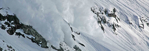

What rules does Greg Hill live by? Watch and see
Watch Greg’s video below to learn the rules and find out why they are important for you too – then scroll down to our interview with Greg to learn more about the life experiences that shaped them.
Greg, let’s start with the obvious: tell use about that avalanche!
May 15th 2014. Deep in the heart of Pakistan, at 5500m, as far from rescue as possible. I only broke my leg, but was very lucky to have lived at all. It was only 30cm high, but it was a few hundred meters across, but the entire feature that I was skiing slid for about 700m vertically.
What did you do wrong?
There was simply nowhere to go – and that was my technical mistake. What I did wrong was skiing a feature with no escape routes or safe spots. I skied like I was able to outrun an avalanche. A small ski cut would have triggered the thing and I would have been on top. But the bigger rule I broke was rule number one – not being afraid enough. I also broke rule number two – the partners I had there weren’t my normal partners. My normal partners would have questioned me more. They didn’t question me enough. Did they learn something from this? I bet they did.
Why did you need to be in that avalanche?
The funny thing is, I had lasted so many years without any issues – I needed that slide to keep my ego in check. There weren’t red flags popping up. We had waited a bunch of days for the snow to settle. The mountains were dormant. But I still broke the rules.
What’s your biggest tip to help you follow the rules?
Keep asking yourself questions. As you’re hiking up. Am i being afraid? Am I well-trained? Do I have the knowledge to back my decisions? Are my partners adding more? Always remember – you don’t know you're making poor decisions, until you experience a consequence.
What can we learn from you next?
This is a lead-in to my terrain tricks video – we’ll discuss concrete, tangible terrain decisions that will help you find ways to wander around the mountains and stay safe.
Stay tuned for more mountain advice from Greg Hill in December!
READ MORE
PREPARE FOR SNOW


World Vertical Week 2016 Big Data
It was a race to the top! National and tribal pride was on the line as people around the world tried to prove their country or sport is king of the hill. World Vertical Week 2016 has closed and the stats are in so it's time to see who came out on top!
WHICH COUNTRY CLIMBS THE MOST?
Surely alpine nations have an unfair advantage? Mostly, yes, but not always. There were a couple of surprises! This visual shows the top 10 countries for average ascents in human powered outdoor activities.
Congratulations Switzerland, Austria and Slovenia!
WHO CLIMBS THE MOST?
Trail runners, cyclists and trekkers were humbled as – maybe unsuprisingly – ski touring and mountaineering led the highest average ascents. As a consolation, remember there would be very different results in summer!
Skiers climbed the most
NUMBER ONE CLIMBERS IN THE WORLD
The Swiss are on top again and nearly breaking the thousand-meter mark in both ski touring and mountaineering. The other two countries with two first places were more surprising: Colombia was on top in running and cycling and Hong Kong topped the chart in both trail running and trekking.
The toughest mountain goats come from the Switzerland.
TOP COUNTRIES IN DIFFERENT ACTIVITIES
And to give you even more to speculate here are the top five countries in the activities mentioned above.
Top 5 in ski touring
SWITZERLAND 996 m
SLOVENIA 941 m
FRANCE 908 m
ITALY 895 m
SLOVAKIA 885 m
Top 5 in mountaineering
SWITZERLAND 971 m
FRANCE 881 m
ITALY 798 m
AUSTRIA 710 m
GERMANY 696 m
Top 5 in trail running
HONG KONG 890 m
CHINA 684 m
ITALY 640 m
JAPAN 553 m
SLOVENIA 543 m
Top 5 in trekking
HONG KONG 705 m
SOUTH AFRICA 519 m
MALAYSIA 428 m
SLOVENIA 424 m
NETHERLANDS 420 m
Top 5 in snow shoeing
ITALY 558 m
AUSTRIA 488 m
GERMANY 428 m
SWITZERLAND 426 m
FRANCE 416 m
Top 5 in mountain biking
PORTUGAL 533 m
ITALY 518 m
SPAIN 479 m
SOUTH AFRICA 452 m
SWITZERLAND 400 m
Top 5 in cycling
COLOMBIA 481m
SOUTH AFRICA 409 m
ANDORRA 403 m
SLOVENIA 396 m
SPAIN 391 m
Top 5 in cross country skiing
SPAIN 367m
CZECH REPUBLIC 351m
FRANCE 298m
NORWAY 261m
JAPAN 248m
Top 5 in running
COLOMBIA 193 m
SLOVENIA 164 m
ANDORRA 148 m
HONG KONG 140 m
PORTUGAL 140 m
READ MORE
7 TIPS TO ACCELERATING YOUR UPHILL SPEED
PERFORMING YOUR BEST WITH VERTICAL SPEED
KIMBERLY, DAVID AND KYLE ARE THE VERTICAL WEEK PHOTO CONTEST WINNERS!


KIMBERLY, DAVID AND KYLE ARE THE VERTICAL WEEK PHOTO CONTEST WINNERS!
World Vertical Week was held last week and the hundreds of pictures tagged with #VerticalWeek give a wonderful look at what people were up to during the event. Thank you very much for participating and sharing the photos, everyone!
The three lucky photo contest winners are Kyle Conway, David Jeker and Kimberly Strom. Congratulations! They all will receive Suunto Ambit3 Vertical GPS watches for their inspiring images.
putting in some more hard miles before #gorge100k @briehemingway @ultracrazychris #teamultracrazy #trailfamily #trailrunning #trailporn #training #suuntoverticalcanada #verticalweek #epictrailrunning #teamtransalpine
A photo posted by Kyle Conway (@kc_lumberguy) on Feb 20, 2016 at 11:08pm PST
Kyle Conway shot his winning photo at his local Baden Powell Trail in North Vancouver, Canada.
“We ran about 30 km with about 1250 m of climbing, including two loops of the "Seymour Grind", a popular "climbing route" for trail runners,” Kyle tells about the day the photo was taken.
Over the Vertical Week Kyle climbed 4700 m.
“2016 has been a year with goals of improving my climbing, and Suunto's Vertical Week was a perfect opportunity to step things up.”
Dream big. #trailrunning #catogne #trailvsb #whatanadventure #waaultra #waateam #verticalweek #livingthedream #jesuisloup
A photo posted by David Jeker (@davidjeker) on Feb 17, 2016 at 8:11am PST
David Jeker used the Vertical Week as his last week of hard training before tapering for Transgrancanaria in early March.
“I ran nine times during the week, always near my place in Salvan, Switzerland. I kept the best training for the end and did some hill repeats on a very steep trail on Sunday. I ran up and down five times for a total of 2300 meters. Totals for the week were 122 km with 4350 meters of ascent.”
David’s photo was taken during a 33 km long run with 1350 meters of ascent.
“I had originally planned on doing an easy run down in the valley but when I saw that the snow had mostly melted higher up, I changed my plan. It was Vertical Week after all! I ran up to one of my favorite trails and took a picture of Catogne,” David says.
“I’m running a race (X-Alpine / Trail Verbier St-Bernard) this summer that goes up, down and around that mountain. Since I’ve registered for that race, the sight of this impressive mountain is always a great source of motivation!”
Finished the week with a big day, +2400m and plenty of sun. #verticalweek #suuntoski
A photo posted by @kimberly.strom on Feb 21, 2016 at 10:38pm PST
Kimberly Strom’s Vertical Week was a true multisport one: she ran in the Jura mountains, nordic skied, and had a big skimo day in the French Alps gaining a total ascent of about 5000 m for the week.
In Kimberly’s photo her friend Noémie leads their climb to Col de l'Encrenaz on the way to Mont Buet (3096 m), in the French Alps.
“The route allowed us a quiet morning, away from the busy ascent of Buet. With some extra skinning we earned the chance to be alone at the summit, arriving late in the afternoon after two long climbs (1300 m and 1100 m).”
Along the way they saw many small avalanches as the sun heated the snow, watched a huge ibex perched on an impossible ledge, took a break to sit protected from the wind and enjoyed the view, kick-turned up icy slopes, and struggled to break through the crusty, crème brûlée descent. When they arrived back at the bottom the towering peaks glowed pink.
“I can't think of a better day than spending all of it with friends in the mountains: working hard, feeling sun and wind burn, rewarded constantly with beauty, feeling accomplishment and the desire to go again.”
Kimberly uses Suunto Ambit3 Sport to track her moves.
“I never leave home without it. Track-back feature helps me find my way after some exploring!”

Win a Suunto Ambit3 Vertical in World Vertical Week’s photo contest
World Vertical Week started today! Share a photo showing your World Vertical Week spirit on Instagram or Facebook between February 15–21, 2016 and tag the photo with #VerticalWeek for a chance to win a Suunto Ambit3 Vertical watch.
The three most inspiring photos will be chosen as winners.
During World Vertical Week every move will add to your country’s totals and soon we’ll find out where in the world people push uphill the most. Track your adventures with your Suunto watch. Every move and every sport counts.
The only thing you need to do to participate in the event is to make sure your country information in the settings is correct. After that your ascent will automatically be calculated in your home country’s total figure.
By the end of the week we’ll find out where in the world the real climbers live and can compare different sports, too. Have fun!
Read the terms and conditions of the photo contest


登山の登りペースを把握する方法|登高速度(VAM)の見方と活用法
登山やトレイルランニングで「この登りはあと何分かかるのか」「序盤から飛ばしすぎていないか」を判断したいとき、平地と同じ1kmあたりのペースだけでは負荷をつかみにくいことがあります。急な登りでは、水平距離よりも標高をどれだけ上げたかがペース管理の手がかりになるためです。
そこで役立つのが、1時間あたりに何m登ったかを示す登高速度です。登り区間の平均登高速度はVAMとも呼ばれます。一方、Suuntoウォッチの「バーティカルスピード(Vertical speed)」は、運動中の上下方向の速度をリアルタイムで確認するデータ項目です。
この記事では、登高速度とVAMの意味、登りの所要時間やペース配分への活かし方、Suuntoウォッチでバーティカルスピードを確認するときのポイントを解説します。
目次
登高速度とVAMとは?
登高速度の計算方法
登りのペース管理に活かす方法
トップアスリートの活用例
Suuntoウォッチで確認する方法
トレーニングでの分析方法
数値を見るときの注意点
まとめ
登高速度とVAMとは?登りのペースを標高差で表す指標
登高速度とは、一定時間にどれだけ標高を上げたかを表す指標です。一般的には「m/h(メートル毎時)」で示され、一定区間の平均値はVAM(Velocità Ascensionale Media:平均登高速度)とも呼ばれます。
VAMとバーティカルスピードは、どちらも上下方向の速さを標高差で捉える点では共通しています。ただし、VAMは登り区間の平均値を指すのが基本です。Suuntoウォッチのバーティカルスピードは、m/hまたはm/minで表示されるリアルタイムの垂直速度で、下りでは負の値を含む場合があります。運動後に区間平均を確認すると、VAMに近い使い方ができます。
たとえば登高速度が300m/hなら、同じペースを保った場合、1時間で標高を約300m上げる計算です。平地のランニングペースが水平距離を基準にするのに対し、登高速度は標高差を基準にします。
指標
基準
向いている場面
ランニングペース
1kmにかかった時間
平地や勾配の小さい区間
平均登高速度(VAM)
一定時間に上げた標高
登山道の登り、急登、登坂インターバル
心拍数
身体への内的負荷
運動強度や疲労の把握
登高速度だけで体力や技術を評価するのではなく、心拍数、勾配、路面、荷物の重さ、標高、天候などと組み合わせて見ることが大切です。
平均登高速度(VAM)の計算方法
平均登高速度であるVAMは、登った標高差を所要時間で割って求めます。
VAM(m/h)=登った標高差(m)÷登りの所要時間(時間)
標高差600mの登りに2時間かかった場合は、600m÷2時間=300m/hです。1時間30分なら1.5時間として計算するため、600m÷1.5時間=400m/hになります。
ここで使うのは、スタート地点と到着地点の単純な標高差ではなく、途中の上り下りを含めた上昇量です。小さな下りを挟むルートでは、単純な標高差より累積上昇量が大きくなるため、ルートデータを確認して計算しましょう。
登り区間の上昇量が分かっていれば、自分が無理なく維持できる登高速度から所要時間の目安も逆算できます。ただし、休憩、渋滞、路面状況、気象条件は別に見込む必要があります。
登りのペース管理に活かす3つの方法
1. 登りの所要時間を見積もる
過去の登山やトレイルランニングから、自分が長く維持できる登高速度を把握しておくと、次の登りに必要な時間を見積もりやすくなります。累積上昇量900mの区間を普段450m/hほどで進めるなら、休憩を除いた登り時間の目安は約2時間です。
2. 序盤のオーバーペースを防ぐ
長い登りの序盤は身体が動きやすく、想定以上のペースになりがちです。登高速度と心拍数を一緒に見れば、「速く登れているが心拍も上がりすぎている」といった状態に気づきやすくなります。距離の長い登山やレースでは、後半まで維持できる強度を優先しましょう。
3. 同じ坂で成長を比較する
定期的に同じ登りを使うと、路面や勾配の違いを抑えて変化を比べられます。同程度の心拍数で登高速度が上がった、または同じ登高速度をより低い心拍数で維持できたなら、登りへの適応が進んだ可能性があります。1回の最高値ではなく、数週間から数か月の傾向で判断してください。
キリアン・ジョルネは登高速度をどう使っていた?
原文では、トレイルランナーでスキー登山競技のアスリートでもあるキリアン・ジョルネが、日々のトレーニングで登高速度を使っていると説明しています。慣れた登りで平均より速いか遅いかを確認したり、登りに必要な時間を計算したりするためです。
2016年の記事で紹介された本人の数値は、バーティカルキロメーターのランニングで約2,000m/h、スキー登山競技で約1,700〜1,800m/hでした。これは世界トップレベルの競技者による当時の参考値であり、一般の登山者やトレイルランナーが目標にする基準ではありません。
重要なのは他人の数値と比べることではなく、同じ条件に近い自分の記録を積み重ねることです。勾配、路面、荷物、疲労、気温が変われば登高速度も変わるため、自分なりの基準を複数のコースで持っておくと実践に活かしやすくなります。
Suuntoウォッチで登りのペースを確認する方法
対応するSuuntoウォッチでは、Suuntoアプリでスポーツモードの表示をカスタマイズし、「高度」関連のデータ項目からバーティカルスピードを追加できます。ウォッチやソフトウェアのバージョンによって、利用できるデータ項目、単位、メニュー名、設定手順が異なる場合があります。
Suuntoアプリで接続中のウォッチを開く
スポーツモードのカスタマイズ画面へ進む
登山、トレイルランニングなど使用するスポーツモードを選ぶ
データ画面に「バーティカルスピード」などの高度関連項目を追加する
ウォッチと同期し、運動前に表示を確認する
長い登りでは現在値だけでなく、心拍数、累積上昇量、経過時間も同じ画面や切り替えやすい画面に置くと、ペースを総合的に判断しやすくなります。登り区間の詳細をリアルタイムで確認したい場合は、対応機種でSuuntoPlus™ Climbを利用できることもあります。
登りで役立つSuuntoの高度機能をまとめて確認する
ラップとSuuntoアプリで登りを振り返る
登りの開始地点と終了地点で手動ラップを記録しておくと、その区間だけを後から比較しやすくなります。ヒルリピートや定点コースでは、次の流れで記録を残してみましょう。
登りの開始地点でラップを記録する
頂上または決めた終了地点で再びラップを記録する
運動後にSuuntoアプリへ同期する
高度、上昇量、心拍数、所要時間などを区間ごとに振り返る
短い瞬間の最高値を追うより、登り全体の平均、心拍数の推移、後半の失速などを見るほうが、次回のペース設定に役立ちます。トレーニングコースを組む場合は、登り・下り・距離を組み合わせた練習コースの選び方も参考にしてください。
登高速度の数値を見るときの注意点
瞬間値は変動する:短い区間では高度計測の揺れや地形の変化を受けやすいため、一定時間または1本の登りの平均も確認します。
条件をそろえて比較する:勾配、路面、積雪、荷物、標高、気温、疲労によって同じ人でも数値は変わります。
心拍数と併用する:速さだけでなく、そのペースをどの強度で維持したかを見ると、持久力の変化を判断しやすくなります。
気圧変化の影響を考える:気圧高度計を使うウォッチでは、急な天候変化が高度表示に影響する場合があります。必要に応じて高度の基準値や自動調整機能を確認してください。
安全を優先する:ウォッチの数値は判断材料の一つです。悪天候、体調不良、危険な路面では、目標ペースより安全な行動を優先してください。
まとめ|登りのペースは自分の基準で管理しよう
登高速度は、1時間あたりにどれだけ標高を上げたかを示し、登山やトレイルランニングの登りを把握するのに役立つ指標です。まずは同じ登りを繰り返し記録し、無理なく維持できる自分の数値を知ることから始めましょう。心拍数や累積上昇量と組み合わせれば、所要時間の見積もり、オーバーペースの防止、トレーニングの振り返りに活用できます。
気圧高度計を備えたSuunto Vertical 2は、登山やトレイルランニングで高度や登りのデータを確認しながら、長いルートのペースを管理したい人に適した選択肢です。初代モデルとの違いを知りたい場合は、Suunto VerticalとVertical 2の比較記事もあわせてご覧ください。
登りの記録に適したSuuntoウォッチを探す
高度、心拍数、ルートなどを記録し、自分の登りのペースを継続的に振り返りましょう。
Suuntoスポーツウォッチを見る


