




SUUNTOブログ


Suuntoアプリで路面情報を確認する方法|登山・トレイル・サイクリングのルート計画に活用
知らない場所でランニングやサイクリングのルートを計画するとき、「この道は舗装されているのか」「トレイルとして走れるのか」は、地図を見ただけでは判断しにくいことがあります。Suuntoアプリの路面情報を使うと、舗装路、滑らかな未舗装路、荒れた未舗装路を地図上で色分けして確認できます。
この記事では、Suuntoアプリで路面情報を表示し、ランニング、トレイルランニング、グラベルライド、マウンテンバイクなどのルート計画に活用する方法を紹介します。
目次
Suuntoアプリの路面情報とは
3種類の路面と色分け
路面情報を表示してルートを作る方法
スポーツ別の活用例
ヒートマップや3Dマップとの組み合わせ
利用前に知っておきたい注意点
まとめ
Suuntoアプリの路面情報とは
路面情報は、Suuntoアプリの地図に道路やトレイルの表面状態を重ねて表示する機能です。行き先の道が舗装路なのか、砂利道なのか、岩や土を含む荒れた道なのかを事前に把握し、アクティビティに合うルートを検討できます。
路面タイプは複数を同時に選択でき、ルートを作成している途中でも表示を切り替えられます。たとえばロードバイクでは舗装路を中心に、グラベルライドでは滑らかな未舗装路を含めて探すなど、目的に合わせた使い分けが可能です。
3種類の路面と色分け
路面タイプ
表示色
含まれる路面の例
活用しやすいスポーツ
舗装路
ライトブルー
アスファルト、コンクリートなど
ロードランニング、ロードサイクリング、ローラースキー
滑らかな未舗装路
イエロー
砂利道、比較的整ったダートなど
グラベルライド、ランニング、ハイキング
荒れた未舗装路
レッド
土、草、泥、岩などを含む道
トレイルランニング、マウンテンバイク、ハイキング
色は路面の分類を見分けるための目安です。実際の通行可否、道幅、勾配、路面の乾燥状態、技術的な難易度を保証するものではありません。
路面情報を表示してルートを作る方法
Suuntoアプリで地図を開く:ホーム画面の地図プレビュー、またはナビゲーションバーの地図アイコンからマップ画面へ移動します。
路面情報を選ぶ:地図のレイヤーから路面情報を開き、表示したい路面タイプを選択します。複数の路面を同時に表示することもできます。
行きたいエリアを確認する:色分けされた道路やトレイルを見ながら、スポーツや装備に合う候補を探します。
ルートを作成する:スタート地点と経由地点を設定し、距離や高度プロファイルも確認します。必要に応じてウェイポイントを追加します。
保存してウォッチへ同期する:ルート名と対象スポーツを設定して保存し、対応するSuuntoウォッチへ同期します。
アプリの画面名やアイコンの位置は、iOS/Android、アプリのバージョン、端末によって異なる場合があります。利用前にSuuntoアプリを最新バージョンへ更新してください。
GPXファイルの読み込みやウォッチへの同期を含む詳しい手順は、「GPXルートをSuuntoウォッチに入れる方法」も参考にしてください。
スポーツ別の活用例
ロードランニング・ロードサイクリング
舗装路を表示すると、走りやすい道路をつないだルートを検討しやすくなります。ただし交通量や歩道、自転車通行規制までは路面タイプだけで判断できません。現地の交通ルールと安全情報も必ず確認してください。
グラベルライド
舗装路と滑らかな未舗装路を同時に表示すると、アクセス区間とグラベル区間を組み合わせやすくなります。タイヤ幅や車体、経験に合わない荒れた未舗装路が含まれていないかも確認します。
トレイルランニング・マウンテンバイク
荒れた未舗装路は、土や草、泥、岩などを含む可能性があるルートを探す手掛かりになります。一方で、降雨後や季節によって難易度は大きく変わります。立入禁止区間や自転車の進入規制、自然保護区域のルールを優先してください。
登山・ハイキング
路面情報だけでなく、等高線、高度プロファイル、距離、予想行動時間を合わせて確認することが重要です。山での計画全体は「登山ルートの計画方法|距離・標高・天候を確認する7つのポイント」で詳しく紹介しています。
ヒートマップや3Dマップとの組み合わせ
Suuntoアプリでは、路面情報のほかにスポーツ別ヒートマップ、2D/3Dマップ、人気ルート、人気のスタート地点などもルート探しに活用できます。
ヒートマップ:ほかのユーザーがそのスポーツでよく利用しているエリアを探す手掛かりになります。
3Dマップと高度プロファイル:登り下りや地形をイメージし、距離だけでは分からない負荷を確認できます。
人気ルート:土地勘のない場所でルート候補を探すときに役立ちます。
ウェイポイント:分岐、補給地点、山小屋など、行動中に確認したい地点を記録できます。
路面、利用状況、標高を別々に見るのではなく、複数の情報を重ねて判断すると、目的に合うルートを組み立てやすくなります。
利用前に知っておきたい注意点
Suuntoアプリの路面情報は、オープンな地理データベースであるOpenStreetMapのデータを利用しています。情報はコミュニティによって追加・更新されるため、地域によってデータの詳しさや更新時期が異なり、現地の状態と一致しない場合があります。
出発前に確認したいこと
通行止め、私有地、立入禁止、工事、季節閉鎖の有無
当日の天候、降水量、積雪、路面状況
距離、標高差、補給地点、エスケープルート
ルートがウォッチへ同期されているか、バッテリー残量が十分か
必要に応じて紙の地図、コンパス、予備電源を携行しているか
地図やナビゲーションは計画と行動を支えるツールですが、安全を保証するものではありません。現地の標識、管理者の案内、交通規則を優先し、状況に応じて引き返す判断をしてください。
まとめ|路面を確認して、目的に合うルートを選ぼう
Suuntoアプリの路面情報を使うと、舗装路、滑らかな未舗装路、荒れた未舗装路を地図上で見分けながらルートを計画できます。ロードランニングからグラベルライド、トレイルランニング、登山まで、スポーツと装備に合う道を選ぶための便利な判断材料です。
ヒートマップ、3Dマップ、高度プロファイルも組み合わせ、出発前には現地の規制や天候を別途確認しましょう。準備したルートを対応するSuuntoウォッチへ同期すれば、アクティビティ中のナビゲーションにも活用できます。
Suuntoアプリで次のルートを計画しよう
ルート作成、路面情報、ヒートマップ、トレーニング分析など、Suuntoアプリの機能をチェックできます。
Suuntoアプリについて詳しく見る

The athlete-entrepreneur who knows the value of hard work
Talk to Christian Meier for a few minutes and it’s clear the former pro road cyclist who competed in all three European Grand Tours during his career is spilling over with ideas and passion to make good things happen.
Exuding entrepreneurial self-belief and drive, Christian lives in Girona, Spain where he juggles multiple businesses while finding time to ride bikes and train for trail running ultra marathons. He’s currently training for the 101 km Courmayeur-Champex-Chamonix (CCC), one of the flagship races at Ultra-Trail du Mont-Blanc (UTMB).
“Ultra races are like grand adventures where you go through the whole range of emotions while spending the day and sometimes night in nature while pushing yourself to your physical limits,” Christian says. “These types of adventures need equipment that can keep up; tough, accurate and with a battery life that makes the journey - it’s the Suunto 9 Baro for me!”
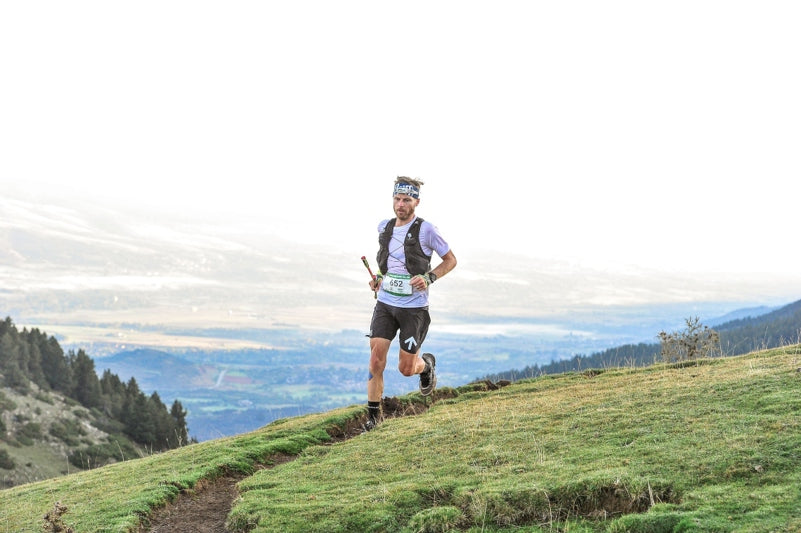
Christian competing at Salomon Ultra Pirineu.
Building businesses for good
While he’s not preparing for that, riding bikes, overseeing his and his wife’s Espresso Mafia roastery and cafe and specialist cycling cafe La Fabrica, he’s building Chance Running, a revolutionary running apparel brand that prioritizes doing good for the planet. With every purchase, Chance Running plants two trees with its partner Tree Nation and offsets 200 kg of carbon and removes one kilogram of ocean bound plastic.
“Chance is an opportunity to rethink the mission of a company - making it mission driven rather than profit driven,” Christian says. “It has allowed us to try and help the planet we are out enjoying everyday, through the avenue we know best, sport. Being carbon neutral is no longer enough and we want to push the boundaries of what’s possible with a planet first approach.”
Where it began
Christian grew up in a hard-working German-Canadian family in a small rural community in New Brunswick in Canada. The “farm-to-table” family worked a farm and ran a butcher shop and restaurant. His mother worked the farm while his father, a machinist, was a capable craftsman who built the family home.
“We lived from the land and I was exposed to an incredible set of skills and work ethic while the whole time being immersed in nature,” Christian says. “Though at the time it was tough being a kid and my summers weren’t at camp like the other kids, but spent on my grandparents farm working. It shaped me into who I am today.”
Christian competing at the Atlas Mountain Race in Morocco, 2019. © Lian van Leeuwen/Atlas Mountain Race
Falling in love with bikes
That upbringing prepared him for the grind of a competitive cycling career. One day as a kid he picked up a mountain biking magazine and that was it - he got a bike and was 100% committed. Cross-country, downhill, road to track - he lived and breathed bikes. So much so he decided he wanted to make riding his job. Pro road cycling was where the money was so he went to Belgium to test the waters. There, by chance, he met a couple of roadies while out cycling and they invited him to train with their team.
“I got my ass kicked to be honest,” he says. “But rather than quit I went home and trained even harder.”
Hard work pays off
It paid off because Christian eventually raced professionally for the Symmetrics, Garmin-Chipotle, United Healthcare and Orica-GreenEdge teams from 2005 to 2016. He won Canada’s National Road Championships in 2008 and had many more domestic race victories. He also placed 15th on day 11 at the 2012 Giro d'Italia.
Now based in the cycling haven Girona, he’s still crazy about bikes; from road, to gravel to bike packing trips and is a prominent member of the local cycling culture.
“Suunto connected to me on a personal level because they take sustainability seriously,” Christian says. “Manufactured in Finland, using renewable energy, refurbishing returned watches. Besides the performance features these are factors that are quite important to me and I am proud to form a part of their community.”
Lead image: © Ultra Pirineu
Allyship in the outdoors: what is it and how to be a good ally for others?
In this article by Suunto athlete, ultra-runner and diversity champion Ryan Montgomery, he explains allyship and how we can all be good allies in the outdoors. Click here to read Ryan’s previous article on the importance of diversity in the outdoors scene.
By Ryan Montgomery
Not everyone feels welcome, nor safe, in the outdoors. Diverse communities—our queer, LGBT, people of color, and peers with disabilities—often experience limitations that prevent them from getting outdoors. Each of us plays a role in eliminating barriers to outdoor spaces for others; being an ally is what will make outdoor recreation safe and accessible for all people.
Photo by Brave Trails, taken at Camp Brave Trails.
What is allyship?
Allyship: We all have heard this word at work, on social media, and in conversation. Perhaps it seems daunting or even time-consuming. However, when I think of allyship, I think of it as a process over time—a process of learning, action, more learning, and more action.
Simply put, becoming an ally for others in the outdoors requires us take an action, using our own varying levels of privilege (which I define as money, knowledge, influence, tools, etc.) to amplify the work and voices of people who historically haven’t had a visible presence in outdoor spaces.
When you can start to think of all the tools you have that can be leveraged for allyship, you will begin to realize you have many ways to make an impact right now.
Photo by Latinos Outdoors.
What is allyship important?
We want everyone to enjoy the experience of the outdoors. With this goal in mind, it’s important to remember that we all experience the outdoors differently. Think about when you pass others on a trail . . . do they smile, make eye contact, or say “hello!” back? Don’t assume these are universal experiences among everyone—they are not. While a lot of us enjoy spending time in nature, it often comes at a price, such as stares and unwanted comments about body weight, skin color, queerness and gender expression, or perceived ability. In more serious situations, the cost of being in outdoor places comes in the form of hostile encounters, racial slurs, or other forms of bullying and acts of discrimination.
Allyship is important because it helps stop these negative outdoor experiences becoming a reality among marginalized communities.
Photo by Brave Trails, taken at Camp Brave Trails.
How can I be an ally to others?
Allyship is action. Yes, there are a lot of different actions you can take to start or develop your allyship. When people ask me how they can start or be a better ally, I suggest these 4 specific ally-building actions:
1 - Speak Up
See something, say something. Don’t be afraid to share and talk about allyship. Have the courage to provide others with learning opportunities about diversity in the outdoors and how to be an ally. Speak about the problem at hand and share what you’re learning. This is a low-hanging action that’s simple, yet highly impactful.
2 – Pass the Microphone
Highlight or elevate the voices of people who don’t act or look like you, including diverse athletes and outdoor leaders and organizations.
Part of allyship is creating more access for marginalized people. If you don’t have a “microphone” to hand over, bring an extra chair, expand the table, or physically give your seat to a marginalized person.
3 – Learn, Don’t Assume You Know Everything:
Probably the most important, is to focus on learning. Ask questions. Lead with curiosity. Listen to others’ stories. Learning about others is the foundational block to allyship. There are plenty of learning opportunities online. The Safe Zone Project provided self-guided LGBT ally training as a resource. In addition to The Safe Zone Project, I have enjoyed learning from the following guides, books, and creators:
Black Faces, White Spaces by Carolyn Finney (Book)
Whiteness in the Outdoors Guide (Guide)
Being an LGBT+ Ally Guide by the Human Rights Campaign (Guide)
Braiding Sweetgrass by Robin Kimmerer (Book)
Alison Desir, black runner and equity advocate (Creator to follow)
4 - Donate to Support Community Groups
If you are privileged financially, consider supporting outdoor affinity or community groups. These groups span across a broad spectrum of non-profits that get communities outside, perform learning and development, or provide education in the outdoor industry and more. Some of my favorite affinity groups and programs that you can support are Brave Trails, Outdoor Afro, and Latino Outdoors.
Photo by Brave Trails, taken at Camp Brave Trails.
Together, we can make the outdoors thrive
Remember that the outdoors teaches us that diversity is necessary for survival—to thrive. If we each do our part, leveraging our own unique privileges to make the outdoors more inclusive for our marginalized communities, then our human ecosystem can truly thrive.
Inspiring organizations and affinity groups to follow and to donate to:
Brave Trails
Latinos Outdoors
Outdoor Afro
Melanin Base Camp
Brown Girls Climb
Natives Outdoors
Indigenous Geotags
Brown People Camping
Unlikely Hikers
Fatgirls Hiking
Indigenous Women Hike
Boccrew
Outthereadventures
Lead images by: Latinos Outdoors


Was this MTB adventure actually a MTB adventure?
Sure, they had their mountain bikes with them. But with terrain so tough it’s hard to even hike it, what to speak of riding it, the question of what to call this madcap adventure arises.
The ragtag group of riding buddies consisting of Kevin Landry, JF Newton, Margus Riga, Kenny Smith, and Peter Wojnar set off on a freeriding adventure deep into British Columbia’s wild and rugged Chilcotin mountain range in search of new freeride lines.
The word expedition suits it better than adventure and 'challenge' doesn’t really do it justice. Watch the video below and read the report from the film crew below and maybe you’ll reach a satisfying way to define it.
One thing is for sure, hardcore!
So Far… We’ve Made It This Far
“No sympathy for the devil; keep that in mind. Buy the ticket, take the ride...and if it occasionally gets a little heavier than what you had in mind, well...maybe chalk it up to forced consciousness expansion: Tune in, freak out, get beaten.”― Hunter S. Thompson, Fear and Loathing in Las Vegas
Niut Valley // North Chilcotins // British Columbia, CanadaLat/long = 51.5900° N, 124.6917° WDay #4 of 810:90 Biking to Hiking Ratio [so far…]
“There may as well have been fucking cows grazing over there and it was the hardest shit ever,” Kenny says, looking back at the snarled mess of terrain we’d spent the last two days traversing through, over and around.
He was bang on, as compared to the convoluted mess of sheer granite, talus fields, and ancient glaciers that lay before us; where we had come from really did look like an idyllic pasture, one that cows could be happily grazing – and it really was the hardest shit ever. We’d ridden our bikes less than 10 % of the time, pushing or carrying them for the other 90… great bike riding trip.
This wasn’t our ‘first rodeo’ as they say but looking down into the ‘venus fly trap’ valley this was the first time we’d contemplated changing our route because the terrain was too complex. Maybe we are getting smarter, realistically we’re just getting softer older. The steady decline in barometric pressure coupled with a few ‘storm warnings’ from our Suunto 9 watches helped to justify our decision while preserving a fraction of our collective egos.
“Stuck in the bottom of the flytrap on a sunny day would be soul-crushing, add 20 centimeters of snow, and hell we might still be there.”
The route, as planned by Captain Kenny from the comfort of his office back in Campbell River BC would wind its way through approximately 200 km, over eight days through the Niut Valley, a remote northern section of the infamous Chilcotins. The Niut, is where the Coast Range meets the Chilcotin Plateau but unlike the ‘Chill’cotins it has no trail network and rarely sees even the most intrepid hikers let alone mountain bikers. I’m not saying we were the first, but I’d bet we’ll be the last [mountain bikers] to that zone.
Since 2016/2017 our little ragtag crew has been refining this style, colloquially referred to as ‘freeride bike packing, by our friend Brice Minnigh. A weird chimera of big mountain MTB riding, ski touring, thru-hiking, bike packing, and mountaineering. The route is usually a point-to-point attempting to link up ridable ridgelines and chutes while minimizing any travel at valley bottom where one must contend with soul-crushing bush.
This brings us back to the siren song of the Venus flytrap, which became easier to ignore as the rain’s tempo crescendo picked up outside our shelters. Turning around the way we came was not an option, it was hard enough once, and would only be harder dragging our tails between our legs. It was becoming clear our only option was to head over the pass at the head of the valley we were currently camped in and attempt to link back up with our original route.
As the crow flies, this was a ‘shortcut’, but not without its own unique challenges. Specifically, a glacier, which fed into an unstable talus field, immediately leading into a few pitches of grade five scrambling. One hand to balance your bike on your pack, one hand on the rock at all times steep. Topping out we were greeted with sideways rain, and a fresh cutting wind no longer sheltered by the lee side. At least this was the easy way I mused.
At the most reductionist, trips in the mountains either work out or they don’t, it's binary once you get down to it. While we didn’t know it yet – the four of us were still shivering in Fraser’s tent at ridgetop – this trip was about to work out. Waiting for us just outside the tent was a phenomenal descent into a valley framed wall to wall with chutes just begging to be lapped. I won't bore you with the details, but we set base camp up for two days and methodically ticked off each one right to left. The weather was beautiful, the dirt was tacky, even went for a few swims in the lake by our camp. Of course, the fireside yarns always worked their way back around to the Venus Fly Trap.
Granted, at that time we didn’t know the mellow 15 km “trail” back to the trucks was actually a 25 km overgrown mess of pain and frustration. Bush so thick we had to remove our pedals just to punch through.
All images © Margus Riga


バイクパッキング初心者ガイド|装備・ルート・荷物を準備する9つのポイント
バイクパッキングは、自転車に必要な荷物を積み、旅やキャンプを楽しむスタイルです。徒歩より広い範囲を移動でき、舗装路だけでなく、グラベルや林道を組み合わせたルートも楽しめます。
一方、普段のサイクリングとは違い、荷物を積んだ自転車の操作、パンクなどの修理、補給、宿泊場所、バッテリー管理まで自分で準備する必要があります。
この記事では、初めてのバイクパッキングで失敗しにくくするために、装備、積載、ルート、修理、補給、安全面で確認したい9つのポイントを紹介します。
目次
バイクパッキングとは?
1. 手持ちの自転車で短く試す
2. 走る路面に合う自転車を選ぶ
3. 荷物は少なく、バランスよく積む
4. 必要な装備を事前に試す
5. パンクと基本修理を練習する
6. 初回は1泊・短距離にする
7. 補給・水・宿泊場所からルートを作る
8. 天候と通信・交通状況を確認する
9. ルートと行動予定を共有する
Suuntoでルートを記録する
装備チェックリスト
よくある質問
まとめ
バイクパッキングとは?自転車旅との違い
バイクパッキングは、バックパッキングのように必要な装備をコンパクトにまとめ、自転車で移動する旅のスタイルです。明確な定義はありませんが、フレームバッグ、サドルバッグ、ハンドルバーバッグなどを使い、比較的軽量な装備で未舗装路を含むルートへ出かけるスタイルがよく知られています。
従来の自転車ツーリングでは、キャリアとパニアバッグへ多くの荷物を積み、舗装路を中心に長距離を旅する場合があります。一方、バイクパッキングは荷物を絞り、グラベル、林道、トレイルなどへ入りやすい構成を重視する傾向があります。
ただし、どちらが優れているというものではありません。宿泊方法、路面、日数、持ち運ぶ荷物に合わせて選びましょう。
1. 高価な装備を買う前に、手持ちの自転車で試す
元記事に登場するアントン・クルピチカは、「最もよい自転車は、すでに持っている自転車」と話しています。最初から専用バイクや高価なバッグをすべて購入する必要はありません。
現在の自転車が安全に整備され、予定する路面へ対応できるなら、まずは日帰りや近距離の1泊旅行で試します。必要な荷物が入るか、積載した状態で安全に操作できるか、長時間乗って痛みが出ないかを確認しましょう。
初回の目的は長距離を達成することではなく、自転車・荷物・宿泊の仕組みを試すことです。レンタル用品や手持ちのドライバッグなどを活用すれば、必要な装備を見極めてから購入できます。
2. 走る路面に合う自転車とタイヤを選ぶ
自転車選びは、「バイクパッキング用」という名前より、実際に走る路面、荷物、身体との相性が重要です。
舗装路中心:ロードバイク、ツーリングバイク、クロスバイクなど
舗装路とグラベル:太めのタイヤを装着できるグラベルバイクなど
荒れた林道やトレイル:マウンテンバイクなど
タイヤ幅、空気圧、ブレーキ、ギア比は、路面と荷物の重さに合わせます。荷物を積むと加速・制動・コーナリングが変わるため、本番前に同じ重量で走行してください。
長時間乗る場合は、サドル、ハンドル位置、シューズなど身体との接点も重要です。痛みやしびれが続く場合は、無理に距離を伸ばさず、自転車店などでポジションを相談しましょう。
3. 荷物は少なく、バランスよく積む
バイクパッキングでは、荷物を増やすほど安心とは限りません。重量が増えると上り坂が厳しくなり、制動距離や操作性にも影響します。
装備を「必須」「状況により必要」「なくても対応できる」に分け、使わない可能性が高いものを減らします。ただし、防寒着、雨具、ライト、修理用品、救急用品など、安全に関わる装備は省かないでください。
積載の基本
重い物はできるだけ低く、車体の中央に近づける
左右の重量差を小さくする
走行中に必要な食料や雨具は取り出しやすい場所へ入れる
バッグやストラップがタイヤ、チェーン、ブレーキへ触れないようにする
防水袋を使い、寝具や着替えを濡らさない
出発前に段差や坂道を含む短いコースを走り、バッグの揺れ、異音、ストラップの緩みを確認します。
4. 必要な装備を事前に試す
新品のウェア、シューズ、バッグ、テントを本番で初めて使うと、擦れ、浸水、取り付け不良などに気づけないまま出発することになります。
元記事のサミ・サウリも、長い旅へ出る前に、実際に使う装備をすべて試すことを勧めています。
ヘルメットとグローブ
自転車用ライトとテールライト
レインウェア、防寒着、着替え
寝袋、マット、テントなどの宿泊用品
バッグと固定用ストラップ
ボトル、給水バッグ、調理用品
スマートフォン、GPS機器、モバイルバッテリー
キャンプ用品は、暗くなる前に設営と撤収を練習します。宿泊施設を利用する場合も、営業時間、チェックイン時刻、自転車の保管方法を確認してください。
5. パンクと基本修理を出発前に練習する
人里から離れた場所でパンクすると、修理できないだけで行動を続けられなくなります。道具を持っているだけでなく、自分の自転車で使えることが重要です。
最低限練習したい作業
ホイールの着脱
チューブ交換またはパンク修理
携帯ポンプでの空気補充
チェーン外れへの対応
緩んだボルトの確認と締め直し
基本的な修理用品
自転車とタイヤに合う予備チューブ
パッチキットまたはチューブレス修理用品
タイヤレバー
携帯ポンプ
対応する六角レンチを含むマルチツール
チェーン用クイックリンクなど、必要に応じた予備部品
チューブレスの場合も、修理できない損傷に備えてチューブを携行するなど、使用しているシステムに合う準備をします。工具の使い方に不安がある場合は、自転車店の講習などで練習しましょう。
6. 初回は1泊・短距離・余裕のある季節にする
最初の旅は、自宅や交通機関から遠く離れすぎない1泊コースがおすすめです。荷物を積んだ自転車で走り、食事を取り、宿泊し、翌日に再び走る一連の流れを確認できます。
距離を伸ばすより、明るいうちに目的地へ着き、落ち着いて宿泊準備ができる計画にします。暑さや寒さが厳しい時期、大雨や強風が予想される日は避けましょう。
初回の計画例:
普段の日帰りライドより短い距離にする
途中で鉄道やバスを利用できるルートを選ぶ
補給できる店舗や水場を複数確認する
整備されたキャンプ場または自転車保管可能な宿を予約する
日没より十分前に到着する計画にする
7. 補給・水・宿泊場所からルートを作る
走りたい道だけをつなぐのではなく、水、食料、宿泊、トイレ、交通手段を含めてルートを作ります。山間部では、地図上にある店舗や施設が営業していない場合もあります。
次の地点を事前に確認しましょう。
食料と水を補給できる場所と営業時間
キャンプ場や宿泊施設の予約・利用条件
自転車通行が禁止されている道路や遊歩道
工事、通行止め、季節閉鎖の情報
鉄道駅、バス停、自転車店、医療機関
途中で短縮できる地点と代替ルート
野営や火気の使用が自由にできるとは限りません。土地の管理者、自治体、キャンプ場のルールを確認し、私有地や立入禁止区域へ入らないでください。
▶︎距離・標高・撤退方法を含む計画の考え方は「登山ルートの計画方法|距離・標高・天候を確認する7つのポイント」も参考にしてください。
8. 天候と通信・交通状況を確認する
出発前に、全行程の天気、気温、風、降水、日没時刻を確認します。自転車では向かい風によって進行が大きく遅れ、雨や落ち葉、凍結で制動とコーナリングが難しくなる場合があります。
山間部では携帯電話がつながらない場所もあります。オフラインで使える地図を準備し、スマートフォンとGPS機器の電池消費を抑える方法、モバイルバッテリーの容量を確認してください。
長い下りやトンネルでは体温が下がりやすく、ライトと高い視認性も必要です。反射素材を取り入れ、昼間でもトンネルへ入る前にライトを点灯します。
9. ルートと行動予定を共有する
単独でもグループでも、走行ルート、宿泊地、出発・到着予定、連絡方法を家族や知人へ共有します。計画を変更した場合も、通信できるうちに知らせましょう。
グループでは、次の内容を全員で確認します。
先頭と最後尾を誰が担当するか
分岐や下り坂での待ち合わせ方法
最も遅い人に合わせるペース
機材トラブルや体調不良時の中止基準
緊急連絡先と保険の内容
交通ルールを守り、無理な速度や夜間走行を避けます。疲労で操作が不安定になった場合は、予定距離より休憩や中止を優先してください。
Suuntoでバイクパッキングのルートを記録する
Suuntoアプリのルート作成機能やヒートマップは、ほかの利用者がアクティビティを記録している場所を参考にしながら、ルートを検討する材料になります。作成したルートは、対応するSuuntoウォッチへ同期できます。
Suunto Vertical 2は、長時間のアウトドア活動で地図とルートナビゲーションを活用したい人の選択肢です。
Suunto Race 2は、大きなAMOLEDディスプレイでルートやトレーニングデータを確認し、サイクリングから複数の持久系スポーツまで記録したい人に適しています。
Suunto Race Sは、コンパクトなサイズで日帰りライドからトレーニングまで幅広く記録したい人の選択肢です。
対応するセンサー、スポーツモード、地図、ナビゲーション機能は、モデルやソフトウェアのバージョンによって異なります。出発前にルート同期、地図表示、バッテリー残量を確認してください。
ヒートマップ上に記録がある場所でも、通行できるとは限りません。私有地、通行禁止、季節閉鎖、道路交通法や地域のルールを現地情報で確認しましょう。
▶︎ルートの作成・同期方法は「GPXルートをSuuntoウォッチに入れる方法」をご覧ください。
▶︎サイクリング用の表示項目は「Suuntoアプリでスポーツモードをカスタマイズする方法」で解説しています。
バイクパッキング装備チェックリスト
走行・安全
整備済みの自転車
ヘルメット、グローブ、アイウェア
フロントライト、テールライト、反射素材
ルートを記録したGPS機器・スマートフォン
修理
予備チューブまたはチューブレス修理用品
パッチ、タイヤレバー、携帯ポンプ
マルチツール、必要な予備部品
衣類・宿泊
レインウェア、防寒着、着替え
寝袋、マット、テントなど予約・気象条件に合う装備
防水袋と固定用ストラップ
補給・緊急用品
水、食料、予備の補給食
救急用品、常用薬、身分証明書、現金
モバイルバッテリーと充電ケーブル
緊急連絡先と共有済みの行動計画
よくある質問
バイクパッキング専用の自転車は必要ですか?
必須ではありません。手持ちの自転車が予定する路面へ対応し、安全に整備されていれば、短い旅から試せます。荷物を積載できるか、タイヤとブレーキが条件に合うかを確認してください。
最初は何km走ればよいですか?
一律の距離はありません。荷物を積むと普段より速度が下がり、休憩やトラブル対応にも時間が必要です。普段の日帰りライドより短くし、明るいうちに余裕を持って到着できる距離を選びましょう。
バックパックだけでも始められますか?
短い試走なら可能ですが、重いバックパックは肩や腰への負担になり、汗もたまりやすくなります。重量を減らし、慣れてきたら車体側のバッグへ分散することを検討してください。
どこでもキャンプできますか?
できません。土地の所有・管理、自治体、国立公園、施設ごとにルールが異なります。許可されたキャンプ場や宿泊施設を利用し、予約、火気、自転車の持ち込みなどの条件を確認してください。
まとめ|最初の目的は「仕組みを試すこと」
初めてのバイクパッキングでは、専用装備をそろえることや長距離を走ることより、自転車、積載、修理、補給、宿泊、ルート確認の仕組みを一度通して試すことが重要です。
手持ちの自転車で短い1泊旅行から始め、荷物を減らし、基本修理を練習しましょう。ルートは走りたい道だけでなく、水、食料、宿泊、交通、代替手段まで含めて計画します。経験を重ねながら少しずつ距離と日数を伸ばせば、自分に合う旅のスタイルが見えてきます。
次の自転車旅を、地図に描こう
Suuntoアプリと対応ウォッチで、バイクパッキングのルートとアクティビティを記録しましょう。
Suuntoウォッチを見る


How to use Karoo 2 bike computer with Suunto
First things first: connect your Karoo 2 with your Suunto account
To get started, connect your Suunto and Hammerhead accounts: Go to dashboard.hammerhead.io and select ‘Suunto’ under ‘Accounts’. Once connected, your rides are automatically synced from your Karoo 2 to Suunto app and the routes planned in Suunto app are synced to your bike computer for navigation. After connecting you will also get access to Suunto cycling heatmaps on your Karoo 2.
If you don’t have a Suunto account yet, download Suunto app from the App Store or Google Play and create one. If you need a Hammerhead account, go to dashboard.hammerhead.io
Learn step-by-step how to connect your Suunto and Hammerhead accounts
See the heatmap on your bike computer
Suunto heatmaps show the most popular rides near you – or at your travel destination. They are great for route planning in Suunto app and offer clear benefits out on your rides as well.
On a Karoo 2 bike computer you can see Suunto cycling heatmaps on the go. So, even without a pre-planned route you will find places to ride. The more the road glows, the more popular the ride has been amongst the Suunto community. And, once it is time to turn back, your Karoo 2 will help you navigate back home!
Learn how to get Suunto heatmaps on your Karoo 2.
Plan routes for your rides in Suunto app
Suunto app has advanced route planning functionalities that you can use even on the go.
When planning a route, toggle between different map layers, 2D and 3D maps and use heatmaps to get inspiration. As you create your route, the app will calculate the distance, vertical meters and estimated duration. That way you can keep track of how long and challenging your route might be.
Once saved the routes are synced to both your Karoo 2 and Suunto watch for navigation. That is super handy especially if you are on a multisport adventure; ride to the mountain navigating with Karoo 2 and continue the hike up with your Suunto watch.
Use the same heart rate belt with your bike computer and watch
The Suunto Smart Heart Rate Belt provides accurate heart rate data without compromising comfort. You can use the same belt with both your Suunto watch and your Karoo 2 bike computer. Just pair it with each device and once you are starting your activity, the belt will be connected. Note that the belt can communicate only with one device at a time. However, no pairing and re-pairing is needed.
See all your rides, runs, skis, climbs and all other activities in one place
You can review your rides recorded with Karoo 2 and all of your activities recorded with Suunto watches in the Suunto app. Your Karoo 2 rides are automatically synced after finishing the activity. Select the default privacy setting of your rides in Suunto app settings (private, your followers, public). You can also change this setting for each activity.
Analyse your progress
Suunto app’s long-term analysis view tracks your training load and helps you stay in balance – whether that means progress, maintaining your fitness or avoiding over-training. With long-term analysis tools powered by TrainingPeaks and all your Karoo 2 rides and Suunto activities in one place, you can now manage your training better than ever.
Learn more about managing your training load with Suunto app.
View your personal heatmap
As you collect data in Suunto app you are building a powerful navigation tool for yourself: My Tracks. My Tracks is a map layer that shows your own activities on the map. That is an awesome way to see where you have been or – when compared with the general heatmap – where you have yet to explore.
My Tracks is also a powerful tool to support your route planning. When re-visiting an area and planning new routes, it helps a lot that you can see your previous rides on the map as well.
View activities as 3D animations
In addition to planning and reviewing your tracks on a 3D map in Suunto app, you can even enjoy your adventures as 3D video animations: Simply go to your activity, hit the play button, and enjoy the views as you climb up mountains, go over passes and storm down winding roads. Share the link with your riding buddies and they will be able to see the 3D animation as well – even on a big screen.
Create an adventure logbook
Having all of your activities in Suunto app will enable you to build an adventure logbook. Add descriptions, photos and videos to your activities and find them later with the search tool.
You can also share the images added in your activities with data overlays: hit the share button, select an image, and customise the data fields to support your story!
Connect with hundreds of 3rd party services
Suunto is proud to have a wide array of partners it cooperates with. From route planning services to training and coaching platforms and more, you are likely to find a service that can enhance what Suunto app offers you. These partner services are now compatible with your Karoo 2 activities as well.
To learn more, go to your profile page in Suunto app and select ‘Partner services’.
Each new Suunto watch comes with a extensive Suunto Value Pack, a collection of benefits and treats offered by Suunto partners. Value Pack deals vary from premium trials to free training plans and discounts from partners like Strava and TrainingPeaks.
Learn more about Suunto Value Pack.


