






SUUNTOブログ


Strava Live SegmentsをSuuntoウォッチで使う方法|設定・対応モデルを解説
いつものランニングコースやサイクリングコースで、「前回より速く走りたい」「坂道区間のタイムを縮めたい」と思ったことはありませんか?
Strava Live Segmentsを利用すると、Stravaで保存した区間をSuuntoウォッチに同期し、走行中に自己ベストとのタイム差を確認できます。
よく走る坂道、近所の周回コース、トレイルの登り区間などを登録しておけば、いつものトレーニングが自分自身とのレースに変わります。
この記事では、Strava Live Segmentsの基本から、Suuntoウォッチへの同期方法、アクティビティ中の使い方まで紹介します。
Stravaセグメントとは?
Stravaセグメントとは、Stravaユーザーが道路やトレイル上に設定した特定の区間です。
同じセグメントを走ったランナーやサイクリストの記録が集計され、自分の過去のタイムや、ほかのユーザーのタイムと比較できます。
セグメントは、たとえば次のような場所に設定されています。
坂道の登り区間
公園や河川敷の周回コース
トレイルの一部
サイクリングで人気の峠
レースコースの一部
競争のためだけでなく、同じ場所を繰り返し走り、自分の成長を確認するためにも活用できます
Strava Live Segmentsでできること
Strava Live SegmentsをSuuntoウォッチで使用すると、セグメントの開始地点へ近づいたときにウォッチが通知します。
セグメントが始まると、自己ベストに対して現在どれくらい先行しているか、または遅れているかを手元で確認できます。自己ベストの記録がない場合は、KOMまたはQOMの記録が比較対象になります。
セグメント終了後には、今回のタイムと自己ベストとの差が表示されます。
PR・KOM・QOMとは?
PR(Personal Record) そのセグメントにおける自分のベストタイムです。
KOM(King of the Mountain) 男性ユーザーのセグメント最速記録です。
QOM(Queen of the Mountain) 女性ユーザーのセグメント最速記録です。
まずはKOMやQOMだけを目標にするのではなく、過去の自分のタイムを更新する使い方がおすすめです。
Stravaの「ルート」と「セグメント」の違い
Stravaのルートとセグメントは、目的が異なります。
ルートは、スタート地点からゴール地点までのコースを案内するための機能です。一方、セグメントは、コース上の一部分を計測し、その区間のタイムを比較するための機能です。
目的地までナビゲーションしたい場合はルート、特定の坂道や区間で自己ベストに挑戦したい場合はセグメントを使用します。
Strava Live Segmentsに対応するSuuntoウォッチ
Stravaが現在案内している主な対応モデルは以下です。
Suunto Runシリーズ
Suunto Raceシリーズ
Suunto Verticalシリーズ
Suunto 9 Peak Pro
Suunto 9 Peak
Suunto 9 Baro
Strava Live Segmentsは、ランニングとサイクリングのアクティビティで利用できます。対応モデルは追加・変更される場合があるため、使用前に最新の対応情報も確認してください。
利用前に準備するもの
Strava Live Segmentsを利用するには、以下が必要です。
Stravaサブスクリプション
Strava Live Segments対応のSuuntoウォッチ
Suuntoアプリ
Stravaアカウント
スマートフォンとSuuntoウォッチの接続
Strava Live Segmentsは、Stravaサブスクリプション向けの機能です。
手順1:SuuntoアプリとStravaを連携する
最初に、SuuntoアプリとStravaのアカウントを接続します。
Suuntoアプリを開き、プロフィールまたは設定から、外部サービスとの接続画面へ進みます。
iOSの場合
「プロフィール」から「ほかのサービスに接続」を選択します。
Androidの場合
「設定」から「アカウント」、「ほかのサービスに接続」の順に進みます。
サービス一覧からStravaを選び、Stravaアカウントでログインします。その後、Suuntoアプリとの接続を許可してください。アプリのバージョンによってメニュー名が異なる場合があります。
以前からStravaとSuuntoアプリを接続していて、セグメントが表示されない場合は、一度接続を解除し、再接続が必要になることがあります。
手順2:Stravaでセグメントをお気に入りに登録する
次に、ウォッチで使用したいセグメントをStravaで探します。
Stravaアプリまたはウェブサイトでセグメントを開き、星のアイコンを選択してお気に入りに登録します。
お気に入りに登録したセグメントは、接続されたSuuntoアカウントへ同期されます。星を外すと、SuuntoPlusのセグメント一覧からも削除されます。
ウォッチへ同期できるセグメント数にはモデルごとの上限があります。多くのセグメントを保存している場合は、実際に使用するものだけをお気に入りに登録しておくと管理しやすくなります。
手順3:SuuntoアプリでStrava Segmentsを確認する
Stravaでセグメントをお気に入りに登録したら、Suuntoアプリを開きます。
ウォッチアイコンから「My SuuntoPlus Guides」を開き、ランニング用またはサイクリング用の「Strava Segments」を有効にします。
セグメントが正しく同期されると、登録したセグメントをガイド内で確認できます。
表示されない場合は、ウォッチが別の同期処理を行っていないか確認し、同期が完了してから再度開いてください。
手順4:アクティビティ開始前にガイドを有効にする
ウォッチでランニングまたはサイクリングのスポーツモードを選択します。
アクティビティを開始する前に、オプションから以下の順に進みます。
SuuntoPlus → ガイド → Strava Segments
ランニングの場合はランニング用、サイクリングの場合はライド用のStrava Segmentsガイドを選択してください。
ガイドが有効になっていることを確認してから、アクティビティを開始します。
手順5:セグメント画面を確認しながら走る
アクティビティ中は、画面を切り替えてStrava Live Segmentsの専用画面を表示します。
ウォッチは、現在地から最も近いお気に入りセグメントの開始地点までの距離を表示します。開始地点のおよそ100m手前まで近づくと通知され、正しい方向からスタート地点を通過するとセグメント計測が始まります。セグメントは進行方向が決まっているため、反対方向から進入した場合は開始されません。
セグメント中は、自己ベストに対して先行しているか、遅れているかを確認できます。
なお、ウォッチが自動的にセグメント画面へ切り替わるわけではありません。タイムや距離を確認する場合は、セグメント画面を手動で表示してください。
セグメント終了後の記録を確認する
セグメントを走り終えると、ウォッチに以下の情報が表示されます。
セグメントの完了タイム
自己ベストとの差
新しい自己ベストを達成したか
KOMまたはQOMを更新したか
アクティビティ終了後にSuuntoアプリへ同期すると、セグメント区間がラップとして記録されます。セグメント中に手動ラップを作成すると、データが正しく表示されない可能性があるため注意してください。
セグメントが開始されないときの確認ポイント
セグメントに星が付いているか
Stravaでセグメントを開き、お気に入りを示す星が付いているか確認してください。
SuuntoアプリとStravaを再接続する
以前からアカウントを連携している場合は、一度Stravaとの接続を解除し、再接続します。
ウォッチの同期が完了しているか
Suuntoアプリでウォッチとの同期が完了してから、セグメントが表示されているか確認してください。
アクティビティ開始前にガイドを選択しているか
Strava Segmentsガイドは、アクティビティ開始前に有効にする必要があります。
正しい方向からセグメントへ入っているか
Stravaセグメントには進行方向があります。反対方向から開始地点を通過しても、セグメントは始まりません。
使用時の注意点
セグメント計測中は、手動ラップの作成やオートラップの使用を避けることをおすすめします。ラップ操作によって、セグメント終了時のタイム表示に影響する場合があります。
また、モデルやソフトウェアによっては、Strava Segmentsガイドと構造化ワークアウト、ほかのSuuntoPlusスポーツアプリまたはガイドを同時に使用できない場合があります。利用前にウォッチとSuuntoアプリを最新バージョンへ更新してください。
Strava Live Segmentsで、いつものコースに新しい目標を
Strava Live Segmentsは、特別なレースに参加しなくても、日々のトレーニングに明確な目標を作れる機能です。
いつもの坂道で自己ベストを目指す。数週間前の自分とタイムを比べる。仲間と同じセグメントに挑戦する。
Suuntoウォッチなら、スマートフォンを取り出さなくても、セグメント中の進捗を手元で確認できます。
StravaとSuuntoを連携して、次のランニングやライドで自分の記録に挑戦してみましょう。

The Secrets of Earth's Hidden Waterways
By Jill Heinerth
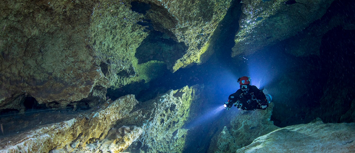
Deep beneath our feet lies a mesmerizing world that remains largely unknown: a network of water-filled caves winding through the darkness, carrying the lifeblood of our planet. As a cave diver, I have dedicated my life to exploring these mysterious subterranean passages. I invite you to join me on a captivating journey into the depths, where fear and discovery converge, and where the delicate balance of survival and exploration unfolds.
The Hidden Pathways
These underground tunnels, sculpted by the gentle touch of rainwater permeating the Earth's surface, act as conduits that transport precious freshwater from deep aquifers to springs, rivers, and estuaries. Ultimately, this water embarks on a journey to the vast ocean, sustaining a thriving plankton community that generates the very oxygen we breathe. The caves I explore serve as the life-supporting veins of our planet, nurturing the lungs that allow life to flourish.
The Thrill of Exploration
While most people recoil at the thought of descending into the darkness of caves, I am irresistibly drawn to their constricted corridors. Equipped with cutting-edge technology and relying on each measured breath, I embrace the unknown depths. In the remoteness of my office, the boundaries between fear and discovery blur, and a single misstep could spell disaster. The exploration of these caves is not without risk, but the reward is an unparalleled sense of fulfillment and a chance to educate others about the fragility of our water planet.
A Perilous Pursuit
Cave diving has rightfully earned its reputation as a dangerous activity, but it also represents the frontier of scientific exploration. Aquanauts, including passionate enthusiasts, daring researchers, and scientists, push the limits of human capability as they navigate through the eternal darkness of labyrinthine limestone networks spanning the globe. Armed with multiple scuba tanks, advanced rebreathers, and swift diver propulsion vehicles, they boldly venture deep into these treacherous passageways, pushing the boundaries of exploration in terms of both distance and knowledge.
Unleashing Art and Science
As a filmmaker and photographer, I find myself balancing the creation of art with the meticulous monitoring of life support equipment in demanding circumstances. Whether I embark on solo adventures or join scientific expeditions, self-sufficiency becomes paramount. There is no Mission Control to solve my problems when I find myself blindly searching for a broken safety line in a cloud of silt with zero visibility. The challenges are immense, but so are the rewards.
Unveiling Hidden Wonders
Through my explorations, I have had the privilege of becoming the eyes and hands of scientists, unveiling a world that has never before been witnessed. Underwater caves serve as virtual museums of natural history, where I collaborate with biologists to uncover new species, assist physicists in studying climate change, and aid hydrogeologists in examining our precious freshwater reserves. These subterranean pathways have led me to grim sources of pollution, vibrant life thriving within Antarctic icebergs, and even ancient skeletal remains of the Maya civilization in the Yucatan Peninsula.
Connecting to the Source
By venturing into the world beneath our feet, I glide through limestone, passing beneath homes, golf courses, and restaurants. I delve into the ancient conduits of volcanoes and navigate crevices within colossal bodies of ice. Following the trail of water, I am guided from mountain creeks to resplendent blue springs, each emitting its life-sustaining bounty from within the heart of our planet. Even when the passages pinch and my dive is forced to come to an end, the water continues to flow from some enigmatic source. The journey is endless, beckoning me forward to explore the caverns, immeasurable to my imagination.
It is a privilege to uncover these hidden shrines and share concealed mysteries from deep inside our planet. I want to connect humanity to where their water comes from and show people that what we do on the land’s surface will eventually be returned to us to drink.
More people have walked on the moon than have been to some of the remote places Jill Heinerth has explored on Earth. Jill Heinerth is a veteran of over thirty years of scientific diving, filming/photography, and exploration. Her expeditions include the first dives inside Antarctica icebergs and record-breaking scientific missions in deep underwater caves worldwide.
Jill’s book INTO THE PLANET – My Life as a Cave Diver has drawn wide acclaim from the New York Times, Wall Street Journal, NPR, and even Oprah magazine. Her children’s book, THE AQUANAUT, has been selected by Dolly Parton’s Imagination Library as a part of her inspirational initiative. Jill bought her first Suunto gear in 1988 and still dives with Suunto.
For more info: www.IntoThePlanet.com


Making outdoor spaces more inclusive
This Pride Month, we are calling all LGBTQIA+ trail runners to participate in the 2nd Annual LGBTQ+ Running Retreat in the North Cascades this October, hosted by Queer Pro Ultra-Runner, Suunto ambassador Ryan Montgomery and Aspire Adventure Running!
Ryan having a blast at the Javelina Jundred 100-miler. (Image by Nick Danielson)
”A couple of years ago when I started becoming more visible as a queer-identifying elite athlete, I recognized that the opportunity to compete at an elite level also comes with the opportunity to make an inclusive impact in the sport,” says Ryan.
“Running has been my conduit and my catalyst for really helping me understand who I am — to come out of my own closet and to be comfortable with my own identity. Part of the genesis of the Out Trails LGBTQ+ Running Retreat is to help other queer-identifying athletes have an opportunity to push themselves physically and mentally, alongside a supportive community, to learn something new about the outdoors or themselves.”
All experience levels are welcome
The LGBTQ+ Running Retreat is inviting 40 runners to Mt. Baker Ski Area, Washington, USA for 3 nights and 2 full days of running/hiking. If you are a member of the LGBTQ+ running community, we encourage you to sign-up for the running retreat now!
And to help eliminate the barrier for some members of the LGBTQ+ community, this Pride Month, Suunto is supporting the event with scholarships for 25 LGBTQ-identifying runners! Also the scholarship applications are now open.
Register for the running retreat here, or apply for the scholarship here!
To learn more about the trip, visit the Out Trails LGBTQ+ Running Retreat Course Page.
READ MORE
The importance of diversity in the outdoors
Allyship in the outdoors: what is it and how to be a good ally for others?
A native runner's perspective on inclusivity


Weekend Adventures around major European cities
This summer, we want to inspire you to take a new, unknown route and have built Weekend Adventure route collections around major European hubs.
We kicked off in June with gravel adventures around Munich and Paris and hiking adventures around Milan and our hometown of Helsinki. For July we have added four more exciting route collections: hikes in Madrid and Berlin and gravel rides in London and Rome! Most routes are within an hour from the city centre and long enough to be split into two day adventures.
Adventuring close to home is not only practical and time-efficient; it’s also good for the environment. You don’t always need to travel far to experience something new. So, pack your tent, get your gear and start exploring – the adventure starts here!
Scroll down for hikes in Berlin, Helsinki, Madrid and Milan or gravel bike rides in London, Munich, Paris and Rome!
Connect with Komoot to get the Weekend Adventure routes on your Suunto
The Weekend Adventure collections are hosted by our partner Komoot. Komoot is a platform that lets you find, plan, and share adventures. Personalized route recommendations and inspiration are in the core of Komoot.
Suunto is fully compatible with Komoot: Once you have connected the two accounts (go to Suunto app’s “Partner services” section and select “Connect with Komoot”) routes planned with Komoot flow automatically to your Suunto app’s route library and your activities tracked with Suunto go to Komoot. Turn-by-turn guidance and all is included in the sync. Learn more about the various Komoot packages
Find tranquility on these hikes in Berlin
Just a few kilometres beyond Berlin's city limits, you'll find tranquillity, magnificent landscapes, sparkling lakes and rivers, but also some thrills. In this Collection, we present three hiking Tours that take you to three regions around Berlin. You'll hike along clear waters, discover mystical wetlands and unique, mangrove-like forests. The Tours all have one thing in common: water plays a major role. Two of the hikes can be completed in a day, an overnight stay is recommended for the third one.
Enjoy the English countryside on a gravel bike
You don’t need to live in the countryside to find fantastic gravel trails. London has a vast network of off-road cycling, with some excellent tracks radiating from the city and transporting you to the serene landscapes of the home counties.
The three tours in the London collection can be covered in a day or two: All of them include a convenient midpoint accommodation option, allowing you the flexibility to extend the adventure over two days if desired.
Hike in vast forests less than an hour north of Madrid
The hiking routes in Madrid take you to the Sierra de Guadarrama National Park and the Sierra Norte region less than an hour north of the city. The area boasts vast expanses of lush forests, fantastic granite formations, mountains that tower over 2,000 metres, important rivers, and impressive limestone ravines.
You can complete all the routes in a day if you wish. Otherwise, you can also spread the distance over two days and stay halfway at a refuge or hostel. We’ve included more information in each route description.
Ride ancient roads in Rome
The gravel cycling routes around Rome venture through the Italian countryside and take you on compacted dirt tracks, ancient paved roads, fast singletrack, and rolling lanes with little traffic. Discover the woods around Lake Bracciano, trace historic routes like the Via Appia Antica, explore the wonders of the Castelli Romani, and pedal along the Regina Ciclarum – the most beautiful cycle path in Lazio – until you reach the seafront and the pine forests of the Roman coast.
These Tours are real adventures that require decent fitness and plenty of determination to complete in a day – the distances are between 97 and 179 km. You can also take it easy and split the route so you have more time to fully enjoy these rich natural and historic places.
Gravel rides just outside of Munich
Get out of the city, leave your stressful week in the city behind with only a few pedal strokes and start your weekend adventure in nature. The green surroundings of Munich are diverse – you circle crystal-clear lakes, dive into bubbling river valleys, enjoy Bavarian country life or taste the specialties of Salzburg.
Best of all: A large part of these three journeys take you away from the paved roads on fine gravel paths or exciting single tracks.
Mountain hikes close to Milan
In this Collection we offer you three truly epic hiking adventures a stone's throw from Milan. Just head north by train or car to quickly reach the foot of the mountains – and what mountains!
These three treks are as spectacular as they are demanding. They will take you to some of the most beautiful places outside of Lecco, close to Lake Como. In each tour we point out refuges or other accommodations where you can stop to eat or spend the night, as well as options to shorten the route, if you wish.
Explore Paris on a gravel bike
In this Collection, you discover the surroundings of Paris in adventure mode. The surroundings of the French capital offer a superb playground for gravel cyclists – this Weekend Adventures Collection is a proof of that!
These three cycling routes are rather long, but you can split them in two stages. Two of them make a loop and one is a point to point. However, that is not an issue as you can get back by train.
Hike in the national parks just outside of Helsinki
Our Helsinki Weekend Adventure Collection features three beautiful hikes accessible from the city. It doesn’t take long to escape the buzz of the city and find yourself immersed in archetypal Finnish landscapes, where the right to roam enables you to explore freely.
Two of the hikes explore parts of the spellbinding Nuuksio National Park, with its glistening lakes, serene woodland and rugged terrain. The third hike discovers the quieter Sipoonkorpi National Park and its nature-rich boardwalks.
Images by Philipp Reiter


Suunto Verticalシリーズでオフラインマップを使う方法|ダウンロードと地図操作を解説
登山やトレイルランニングの前に、Suunto Verticalシリーズへオフラインマップを入れておけば、スマートフォンの電波が届きにくい場所でも現在地や周囲の地形をウォッチで確認できます。ただし、地図は購入時からすべて入っているわけではありません。出発前にSuuntoアプリでエリアを選び、Wi-Fi経由でウォッチへダウンロードしておく必要があります。
この記事では、Suunto Vertical/Suunto Vertical 2に共通する基本的な流れとして、オフラインマップをダウンロードする手順、ウォッチ上での表示・操作方法、うまくいかないときの確認項目を解説します。ソフトウェアのバージョンによってメニュー名や画面表示が異なる場合は、ウォッチに表示される案内と最新のユーザーガイドも確認してください。
目次
オフラインマップでできること
ダウンロード前の準備
オフラインマップをダウンロードする手順
ウォッチで地図を表示・操作する方法
地図とルートナビゲーションの違い
ダウンロードできないときの確認項目
登山前のチェックリスト
まとめ
オフラインマップでできること
オフラインマップは、あらかじめウォッチへ保存して使う地図です。携帯電話の通信圏外でも、GPSで取得した現在地を地図上に表示できます。アクティビティを記録せずに地図だけを見ることも、登山やランニングの記録中にナビゲーション画面として使うこともできます。
Suunto Verticalシリーズでは、用途に応じて地図スタイルを切り替えられます。通常のアウトドア地図に加え、高コントラスト表示や暗い環境に適したダーク表示などがあり、周囲の明るさに合わせて視認性を調整できます。
注意:オフラインマップは安全を支える便利な機能ですが、通信、GPS、バッテリー、操作状況などの影響を受けます。山では紙地図やコンパス、予備電源も用意し、ウォッチだけに依存しないでください。
ダウンロード前の準備
作業を始める前に、次の条件を整えておきましょう。
Suunto VerticalシリーズのウォッチとSuuntoアプリがペアリングされている
Suuntoアプリとウォッチ本体が最新バージョンになっている
ウォッチのワイヤレスネットワーク設定がオンになっている
機内モードと省電力モードがオフになっている
安定したWi-Fi環境と充電ケーブルがある
地図データはスマートフォン経由ではなく、Suunto VerticalシリーズのウォッチがWi-Fiへ直接接続して受信します。2.4GHz帯のWi-Fiを使用し、ホテルや空港など、接続後にWeb画面で追加認証が必要なネットワークは利用できない場合があります。自宅などの安定したWi-Fiで準備するのが確実です。
オフラインマップをダウンロードする手順
1. SuuntoアプリでWi-Fiを登録する
Suuntoアプリを開き、ウォッチのアイコンからウォッチ設定へ進みます。
「ワイヤレスネットワーク」を選択します。
「ネットワークの追加」をタップし、利用するWi-Fiを選びます。
パスワードを入力して接続します。
自宅や職場など、複数のネットワークを登録することもできます。設定項目が見つからない場合は、ウォッチとアプリの更新状況、ペアリング状態を確認してください。
2. ダウンロードする地図エリアを選ぶ
Suuntoアプリのウォッチタブにある「オフライン地図」、または地図画面からダウンロード画面へ進みます。地域名を検索するか、国や近くの場所から目的のエリアを選択し、「ウォッチの地図をダウンロード」をタップします。
必要以上に広いエリアを選ぶと、データ量が大きくなり、完了まで時間がかかります。登山やレースで使う場合は、予定ルートだけでなく、迂回や下山に使う可能性のある周辺エリアまで含めて選びましょう。複数のエリアを選ぶと、順番にダウンロードされます。
3. ウォッチを充電器につなぐ
ウォッチを充電器に接続し、登録したWi-Fiの通信範囲内に置きます。ダウンロード中は、充電器とWi-Fiの両方への接続を保ってください。完了するとウォッチに通知が表示されます。
ケーブルが外れたりWi-Fiが切れたりすると、処理は一時停止します。再接続すると自動的に再開するのが基本ですが、再開しない場合はアプリでいったんキャンセルし、もう一度エリアを選び直します。
ウォッチで地図を表示・操作する方法
ここからは、Suunto Verticalシリーズに共通する基本的な操作方法を紹介します。ダウンロードした地図は、単独で確認する方法と、エクササイズ中に表示する方法があります。
アクティビティを開始せずに見る
時計文字盤から上にスワイプするか、下ボタンを押します。
「地図」を選択します。
GPSが現在地を取得すると、ダウンロード済みの地図が表示されます。
エクササイズ中に見る
GPSを使用するスポーツモードを選択します。
開始前のオプションで「地図」を開き、使用する地図スタイルを選びます。
通常どおりエクササイズを開始します。
中央ボタンで画面を切り替え、地図画面を表示します。
地図を「オフ」にしている場合は、地図の背景が表示されず、移動してきた軌跡を示すパンくず表示だけになります。
Suunto Verticalシリーズの地図画面の基本操作
操作
主な動作
上ボタンを短く押す
ズームイン
上ボタンを長押しする
ズームアウト
下ボタンを押す
ナビゲーションオプションを開く
地図をドラッグする
地図を移動する(タッチ操作が有効な場合)
地図をタップする
現在地を中心に戻す
ボタンロック中は、地図画面のボタンやタッチ操作を使えない場合があります。上記はSuunto Vertical/Suunto Vertical 2の基本操作です。ソフトウェアのバージョンによって画面表示や一部の動作が異なる場合は、各モデルの最新ユーザーガイドも確認してください。
地図とルートナビゲーションの違い
オフラインマップは「周囲に何があるか」を確認するための背景地図です。一方、ルートナビゲーションは、Suuntoアプリで作成または読み込んだルートに沿って進むための機能です。
地図のみ:現在地、道、地形などを見ながら自分で進路を判断する
ルートナビゲーション:予定した線と現在地を重ね、コースから外れていないか確認する
パンくず表示:自分が通ってきた軌跡を確認する
初めての山域や分岐の多いコースでは、地図エリアを保存するだけでなく、予定ルートもウォッチへ同期しておくと確認しやすくなります。ルート作成については、関連記事「次の冒険のルートを計画する6つの方法」も参考にしてください。
ダウンロードできないときの確認項目
ダウンロードが始まらない、途中で止まる場合は、次の順に確認します。
ウォッチが充電器に正しく接続されているか
登録したWi-Fiの通信範囲内にあるか
機内モード、省電力モードがオフか
ウォッチ側のワイヤレスネットワーク設定がオンか
Suuntoアプリとウォッチが最新バージョンか
Wi-Fiが対応する周波数帯か
ネットワークにブラウザでの追加認証が必要ではないか
ウォッチの空き容量が不足していないか
接続条件を満たしても再開しないときは、Suuntoアプリで該当するダウンロードをキャンセルし、必要なエリアを選び直してください。詳しい手順は公式サポート「Suuntoウォッチにオフライン地図をダウンロードする方法」でも確認できます。
登山前のチェックリスト
地図をダウンロードしただけで安心せず、出発前に実際の表示と操作まで確認しておくことが大切です。
目的地と周辺のエリアがウォッチに保存されている
予定ルートがウォッチへ同期されている
地図画面を開き、現在地が表示される
ズーム、移動、地図スタイルの切り替えを操作できる
コンパスを較正している
ウォッチを十分に充電している
活動時間に合うバッテリーモードを選んでいる
紙地図、コンパス、予備電源、行動計画も用意している
地図データや登山道の状況が常に最新とは限りません。通行止め、積雪、崩落、天候、現地の規制は、自治体や管理団体などの最新情報も確認してください。
まとめ
Suunto Verticalシリーズのオフラインマップは、SuuntoアプリでWi-Fiを登録し、必要なエリアを選んで、ウォッチを充電器につなぐことでダウンロードできます。山へ向かう当日ではなく、自宅で余裕を持って設定し、地図表示とルートの同期まで確認しておきましょう。
後継モデルのSuunto Vertical 2については、「Suunto Vertical/Vertical 2が登山用GPSスマートウォッチにおすすめの理由」で登山向けの特徴を紹介しています。初代Verticalからの買い替えや、どちらを選ぶか迷っている方は、「Suunto VerticalとVertical 2の違いを比較」も参考にしてください。事前準備と複数のナビゲーション手段を組み合わせて、安全な冒険につなげましょう。
オフラインマップ対応のSuuntoウォッチを探す
登山、トレイルランニング、日々のトレーニングに合うモデルを比較できます。
Suuntoスポーツウォッチを見る


Get feedback from the Suunto coach
The role of a coach is to provide guidance, support, and expertise to help athletes achieve their goals. A coach can be crucial for monitoring progress and providing feedback and adjustments as needed to ensure the athlete is training safely and effectively.
A great coach is also a friend and a companion in your journey. A coach motivates you and requires accountability. Overall, a coach helps athletes improve their performance, avoid injury, and reach their full potential. This is also our goal when providing you with Suunto Coach.
Suunto app's Training zone includes Suunto Coach, an integral part of the service. It uses AI to look at hundreds of different parameters after each workout, learn how you train, and build a normal training pattern that evolves from every workout you do. Based on this, it can give you the key highlights of your training, recovery, and progress. It provides insights and suggestions for the current week, so you can adjust your effort level as you go forward.
The Suunto coach recognizes areas you are missing in your training this week that you normally are focusing on: Are you lacking volume in your swim workout? Do you push yourself too much with high-intensity runs?
The Suunto coach is not trying to push your training in a direction that you are not used to. For example, if you usually do just high-intensity training, the Suunto coach is not going to ask you to focus more on lower-intensity sessions.
Suunto coach doesn’t really know what is your goal or if you want to follow some specific training methodology. But what it does, is alert, highlight, and comment when you are exceeding healthy limits or just lacking some training aspects you are used to. Suunto coach is there to keep you on your selected path. Its recommendations and highlights are easy to digest without you needing to dig deep into the data.
Now, go to the Suunto app and meet your new coach – the coach already knows you based on your training history!
Lead image by @rsalanova
READ MORE
Manage your training with Suunto app's Training zone


