


Suunto Blog

7 pictures that will make you sign up for the epic Alps stage race
The GORE-TEX Transalpine Run across the Alps demands just as much mental toughness as endurance. For those who have what it takes, an unforgettable adventure awaits.
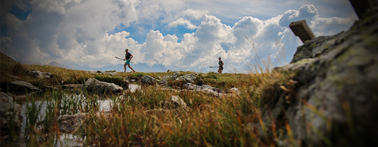
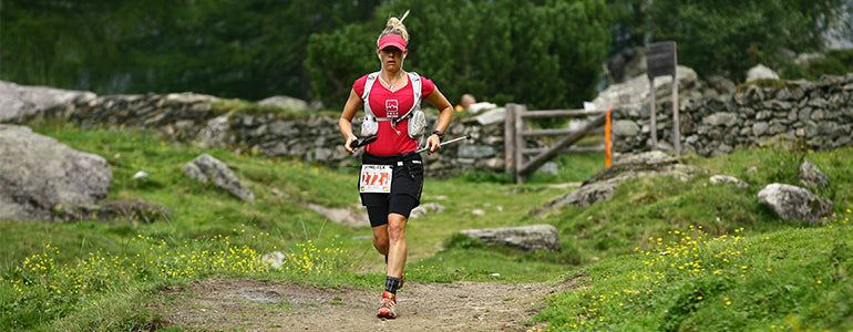
Suunto-supported trail runner Philipp Reiter has competed in and photographed the GORE-TEX Transalpine Run four times, including the 2016 edition that finished in September. He and teammate Iker Karrera won the 2012 edition.
The seven-stage, 247.2 km race was the 12th edition and followed a new route. It included 14,862 m of vertical ascent, rocky trail and a glacier crossing. All participants must compete in a two-person team.
Due to injury Philipp couldn’t compete this year, but he was there to photograph its beauty and intensity. He tells us all about it below.
Stage one: Garmisch-Partenkirchen, Germany to Lermoos, Austria
Distance: 36.7 kmVertical ascent: 2088 mVertical ascent: 1791 mHighest point: 1634 m
Experiencing the cultures of the Alps is part of the fun. © Philipp Reiter
I’ve seen the same thing every year; some of the top teams start too fast and push too hard and bomb out because one team member becomes exhausted. It’s important to remember there are six more days after the mountain run on the first day. It’s best to hold back.
Stage two: Lermoos, Austria to Imst, Austria
Distance: 33.8 kmVertical ascent: 2009 mVertical descent: 2237 mHighest point: 1742 m
© Philipp Reiter
A lot of teams from north Germany, the Netherlands and Denmark compete. Maybe they’re good runners, but they underestimate the terrain – the rocky trail and the ascent. They don’t move fast enough to meet the cut off times of each stage. It’s more like a speed hiking race than a running race. You have to train your muscles to climb day after day.
Stage three: Imst, Austria to Mandarfen-Pitztal, Austria
Distance: 47.9 kmVertical ascent: 3037 mVertical descent: 2144 mHighest point: 2292 m
© Philipp Reiter[To properly prepare] you have to get your body used to doing endurance workouts many days in a row. Usually people work so they only have the weekend. But you need to try to do long sessions six or seven days in a row. Your body has to know what that feels like.
Stage four: Mandarfen-Pitztal, Austria to Sölden, Austria
Distance: 25.7 kmVertical ascent: 1887 mVertical descent: 2214 mHighest point: 2982 m
This year's race included a glacier crossing. © Philipp Reiter
[My mental strategy] is to cut the course into smaller pieces and objectives. For example, I focus on going from food station to food station or from stretch to stretch, climb to climb. Getting to that next location becomes the only goal.
Stage five: Sölden, Austria to St. Leonhard in Passeier, Italy
Distance: 33.3 kmVertical ascent: 1453 mVertical descent: 2111 mHighest point: 2492 m
© Philipp Reiter
Everyone goes through ups and downs. If you and your race partner get along well then he or she motivates you and the other way around. Usually one is up and the other is down and you can help to pull each other along. If you work together you can equalise the weaknesses of each other.
Stage six: St. Leonhard in Passeier, Italy to Sarnthein, Italy
Distance: 33.6 kmVertical ascent: 2440 mVertical descent: 2153 mHighest point: 2683 m
© Philipp Reiter
This year a lot of people struggled during stage six. The mood was at a really low level, with a lot of tired faces. One team took a taxi and went home.
Stage seven: Sarnthein, Italy to Brixen, Italy
Distance: 36.4 kmVertical ascent: 1934 mVertical descent: 2348 mHighest point: 2440 m
© Philipp Reiter
I enjoy this race because for the seven days you live in your own little world, with hardly any influence or contact with the outside world. You can switch off and focus on this one simple undertaking.

Training for the love of it
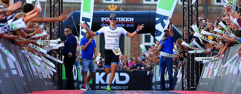
Suunto athlete Patrik Nilsson was a long distance runner, but it didn’t satisfy his desire to train. Then triathlon found him, and now he’s one of the fastest in Ironman history. © KMD IRONMAN DenmarkAt this year’s KMD Copenhagen Ironman, 25-year-old professional triathlete Patrik Nilsson had his mind set on one thing – having fun – but he achieved much more. He came first, smashed his own best time by 20 minutes and got the seventh fastest time in the history of Ironman: 07h49m18s. “It was the perfect day,” he says. “In Denmark it’s so open, and flat, and close to the sea so there’s always wind, but that day there was no wind. When we did the swim it was all flat, no waves at all. The conditions and course were perfect for a really fast day.” Only one year ago, Patrik wasn’t in such good form. Personal difficulties with his then coach were adversely affecting his training and outlook. It all came to a crunch at Ironman Cozumel 2015. He was in first position, with only 10km of the run remaining. But he was hating it so he quit and walked home. “To do well in races, you need to have fun,” he says. “That’s why I couldn’t run those last 10km; when it starts to get tough, you need to feel that it’s fun, and that’s what I felt again in Copenhagen.” © KMD IRONMAN DenmarkFrom Stockholm, Sweden, Patrik has lived to train since he was a kid. At school, he competed at a high level in long distance running, but it didn’t quench his thirst for training. He did his first triathlon in his last year at high school and finally found a worthy outlet for his energies. “With triathlon, there’s always something you can train,” he says. “If you can’t develop your running, maybe you can work on the swim or the bike. There are so many aspects. That’s what inspired me.” Patrik is currently training for Ironman Barcelona 2016. If he performs well, he’ll qualify for the Kona world championships in 2017. He’s working with a new coach, who also happens to be his girlfriend. “It’s good to have a close connection with my coach, which is easy when the coach is your girlfriend,” he says. “It makes it really easy for her to understand how I’m feeling. “There have been a lot of small things we’ve been trying to work on. One of the biggest was around my mentality – to make sure I’m having fun and really enjoying it. It’s worked out perfectly.” While he enjoys pushing his limits with racing, Patrik doesn’t overdo it. Training is what he loves and that’s the focus for most of the year. “For me, it’s better to have one, two or three months of really good training and then do one race and go really hard,” he says. “The most important thing is to have fun. “In Copenhagen I really felt it was fun, I really enjoyed standing on the beach next to the guys and saying, ‘I’m really going to beat you, I’m going to kick your ass and this is going to be fun’. That gives triathlon something more than just the expectation you should win.”
Stay tuned for part two of series about Patrik!
MAIN IMAGE: © KMD IRONMAN Denmark

How to get through a 100-mile ultra marathon
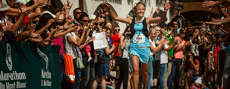
Gediminas Grinius won silver at this year’s 170 km (105 mile) Ultra Trail du Mont Blanc – UTMB, one of the world’s premier ultra marathons. His secret? It’s staying relaxed and finding his inner warrior. Gediminas finding his inner samurai before an ultra marathon in Japan. © Gediminas Grinius
Lithuanian ultrarunner Gediminas Grinius is riding a high after an outstanding performance at UTMB in France. Winning silver tastes especially sweet because in last year’s race he pulled out due to injury.
“Before this year’s race I felt very good, the best shape ever,” he says. “My preparation was excellent.”
Here are Gediminas’s tips for the different phases of an ultra marathon.
Race day morning
It’s easy to feel pressure and stress before a race begins. It’s important to do what you need to do to stay calm. The best way to do that is to stick to your routine, rather than adjusting it for others. I like to spend time with my family, just enjoying life, before a race begins.
© Gediminas Grinius
The start
The beginning of a race is often very fast and chaotic. Later in the race, many runners that started too fast are dead. It’s important to be patient, to keep calm and follow your own pace. Don’t try to keep up with other runners. The race is long so it’s good to keep reserves for later. Now it’s time to relax and enjoy the race.
It’s also important to begin and maintain your nutrition routine, whether you measure it by aid stations or by time.“Pain is temporary, glory lasts forever.”
Settling in
As the race settles down, my plan is to stick to other runners, following their pace because together we’re stronger. It helps me to feel stronger and I can push more from that place.
I’m not a good runner in the beginning. The first 30 or 40 km I’m warming up. After that I know how the race will be because I can feel how my body is reacting. If my body lets me go at a good pace, then I go with that. If it’s not my day, then I go with that, and back off.© Gediminas Grinius
The suffering
Eventually you reach a point when you are suffering. It’s impossible to avoid. You know it’s going to happen. You must be patient. I always remind myself, “pain is temporary and glory is forever”. If you’re suffering, remember it will pass.
When I’m struggling, I use a mental technique. For example, when I was in Japan competing in the Ultra-Trail Mt Fuji, I imagined I was a samurai warrior fighting bad guys. It’s a kind of mental game to cope with difficulties. I visualise myself as different characters.© Gediminas Grinius
“As a father, I remember I’m setting a good example to my children – to finish whatever you start.”
Ending strong
During the final stage, I’m thinking about things that generate positive emotions. For example, I think about my family and how grateful I am they supported me during the long night of the race. It gives me some push and I can move faster. It’s about cultivating good vibes. I know I will feel so much when I see them. As a father, I remember I’m setting a good example to my children – to finish whatever you start. My kids see how stubborn I am and that I do what I love. It’s a good lesson for them.
Follow Gediminas's adventures on his Facebook page.
Other stories with Gediminas Grinius:
Tips for transitioning from road to trailThe Gediminas way of recovery
Main image: © Gediminas Grinius

Recovering from injury with Emelie Forsberg
When you’re doing a sport you love, getting an injury can be devastating. Something mountain athlete Emelie Forsberg knows too well. After ACL surgery in February she has just won KIMA (August 29, 2016). Going from being unable to walk to winning the tough 52km skyrace, she’s undoubtedly delighted. A balanced state of mind helped her get there, and that meant embracing the dark days, while celebrating every tiny rehab victory. We’ve spoken to her about the process, here’s what she had to say.
Emelie Forsberg has recovered after ACL surgery. ©Jordi Saragossa
First things first, how are you feeling after winning KIMA?
I feel good, my legs feel fine today! I ran very conservatively as it’s still early to do a lot of running, but I wanted to try. I ran carefully and I knew it was my kind of course, there are some parts where you have to go fast but it has a lot of very technical parts and I like that. I knew I could do OK but I really did not know how I would be after four hours as I hadn’t been able to run and I was nervous. But I had enough energy at the end and I’m very happy!
Looking back on your surgery, what was important in those early days?
I was very lucky to have surgery immediately. The first days after the injury were horrible. I think maybe it was better it wasn’t me who caused the injury, there was a crash, as I would have been very angry at myself. I was sad as I have devoted my life to being a mountain athlete so it was like my whole world disappeared. It was important to let myself feel like that, and it shows it really means something to me. It was hard, but I knew it would end and I began studying to understand the process and the anatomy behind everything.
What did you do physically to get to where you are now?
I was really careful with rehab and I didn’t do too much in the beginning. I had some simple exercises to do every day. I learned to walk again properly after the first four weeks as I couldn’t walk, it was crazy. I took it step by step and had goals, I never pushed further than I knew was possible and that was important. On week 9 I wanted to run a few steps, and I felt good that day, so I did it. It’s important to have small goals and adjust them as you progress.
Taking small steps got her back on the mountains
How did you stay strong mentally?
It was important to talk to friends, particularly those who also had injuries. You can share something that’s very hard, as they’ve also had something they love taken away. I had very dark days too, but I didn’t dislike them! I liked to have dark days as I was sad and I wanted to be sad as so much had been taken away but I also knew I could step out of that, I could have some distance from it. It’s important to remember there’s more to life than sport. I tried to focus on other things as it sucks to have something you love taken away!
Yoga helped you a lot during your recovery, is that right?
I did a little yoga from week 2 and I think when I was feeling feeling a bit low it would have been good to do more, but when you’re not in a good mood, it’s hard even to do yoga! Maybe yoga was most important to help me know my body, as you really feel everything.
Emelie will get back to skimo this winter
So, what’s next for you?
I’m travelling to India to do the final 200 hours of yoga teacher training. I think it’ll be pretty intense. After that I think I’ll do some more running, then I’ll start to prepare for skiing.
Are you nervous about getting back to ski mountaineering?
I feel quite ok actually. I have two seasons, so now that I am back running it feels natural to get back into skis. I feel comfortable going downhill again so I’m feeling good about it!
Follow Emelie on her website, Facebook and instagram.
Main image ©Jordi Saragossa

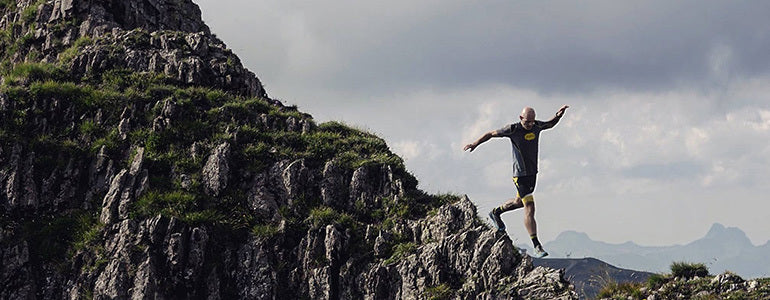
How to smash a stage trail race
Trail runner Rene Unser tells us what it takes to keep going during a multi-day race.
Image: Klaus Fengler (Feature image: Schneider Outdoor Visions)
Five-time Trans Alpine Run competitor and coach Rene Unser is passionate about trail running, in particular partnered staged races. No wonder, as she fell in love with the sport after her would-be husband coaxed her from the roads and onto the trails. She never looked back and she shares some of that passion here, as she explains what’s needed to smash a staged run.
Strategy is key
Having a fine tuned strategy is something important to Rene, in fact it’s one of the things she loves most about these races. She says: “I enjoy the strategy involved in preparation, racing and recovery. The preparation forms my lifestyle and it’s the favourite part for me.”
Care for your partner
Being in sync with your partner could make or break a race. Rene says: “Learn to work with your partner on and off the trails. Very rarely will you and your partner feel good at the same time. You need to work together and understand what the other needs.” Image: Klaus Fengler
Perfect your pace
Can you keep that pace through the whole race? Rene says you need to find out: “Learn your pace and check in with yourself – can you sustain this pace for the whole race, for many days. Try splitting your race into half and run the first half at a moderate, comfortable pace. After the half way mark you can reassess your capability to increase your efforts as you get closer to the finish.”
Know your strengths
No one has a perfect race, and that’s ok. “Most people will learn their strengths and weaknesses as their training progresses. Know there will be stages that won’t always match your strengths,” says Rene. “Do research on the daily profiles and recognise when the terrain will complement your strengths and try to capitalise on this,” she adds.
Get started
Perhaps not an eight-day trail run, but get out on the trails. Rene says: “I really encourage people if they love running long distances to give it a try. Stage races bring the world together, and I’ve met so many people and travelled to so many amazing places, it’s more than just a race!” And road runners should start slowly, she adds: “It’s a good idea to learn technique from a coach to avoid injury or join a running club to learn from others. Often the first thing I tell road runners when they make the transition to trails, is to change their mind-set, as we do a lot more hiking and road runners are not typically used to this.”
Follow Rene on her website, Facebook, instagram and personal website.
READ MORE:
5 INVALUABLE STAGED TRAIL RACE TRAINING TIPS
HOW YOGA CAN MAKE YOU A BETTER MOUNTAIN RUNNER
FOUR MYTHS ABOUT ULTRA-RUNNING THAT YOU NEED TO KNOW
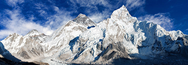

Kilian Jornet’s game plan for speed ascent of Everest
Suunto ambassador Kilian Jornet is acclimatizing in the Himalaya so he can attempt to set a fastest known time (FKT) record on the highest mountain in the world – Everest. We caught up with him and found out the game plan for his daring project.
It’s literally the “high point” of his Summits of My Life project – alpinist, runner and adventurer Kilian Jornet’s personal mission to set ascent and descent records on the most important mountains on the planet, culminating with Everest.
Denali, Mont Blanc, the Matterhorn, Aconcagua, Kilimanjaro – all have seen records fall to Kilian. But now he’s readying himself for the ultimate challenge.
He has been preparing for months. Intense training, sleeping nights at 4500 m in the European Alps, and now he's in Nepal, doing the same at 6000 m.
“The highest I have been is 7700 m,” Kilian says. “I was feeling good then, but there is a big difference after 8200 m and after 8500 m.
“It’s really important to be well acclimatized to around 6000 m. So I will spend many nights at around this altitude. And then it’s important I go to around 8000 m before the attempt.”
Kilian and his team has arrived in Kathmandu and is getting ready for the expedition.
Depending on how well he acclimatizes, Kilian expects to make a FKT (fastest known time) attempt around mid September. It also depends on weather and snow conditions.
The plan is a light and fast, alpine-style ascent. He will carry only what he can fit a backpack. To keep weight down, he and his team have designed light, but warm boots made for purpose. He won’t be fixing ropes or using supplementary oxygen on the ascent. He will attempt the ascent from the north side, via either Norton-couloir or Horbein-couloir depending on conditions.
Two previous ascents are in the back of Kilian’s mind as time references. The first is a speed record set by Italian mountaineer Hans Kammerlander in 1996. Hans climbed from Base Camp to the summit of Everest via the North Col in 17 hours. The second reference is an “unprecedented and unrepeated” ascent in 1986 by Swiss climbers Erhard Loretan and Jean Troillet. They climbed the North Face via the Hornbein-couloir in a single alpine-style push without oxygen, ropes, or tents and descended again – all in 43 hours.
“It’s good to know these times as a reference for pace at altitude,” Kilian says. “I will take this as knowledge and will see how far I can go."
“It’s a big mountain, and we have a long term perspective. We will try this year, but probably we will need to come again next year."
“You need to go for it so if conditions are good and if I’m feeling good, I should try. But it’s important to have the patience to wait for this good moment.”
READ MORE
This is how Kilian prepares for Everest
Main image: © Daniel Prudek/Shutterstock.com


