


Suunto Blog


Good times in the Himalaya for Ueli Steck
For the last two weeks, Suunto ambassador and alpinist Ueli Steck has been in Nepal acclimatizing to the higher altitude to prepare to climb the notoriously difficult south face of 7861 m Nuptse. After recently running up a 6000 m mountain there in his running shoes, it's clear things are going well so far for the Swiss Machine. Here's part two of our four part series on Ueli's Nuptse expedition.
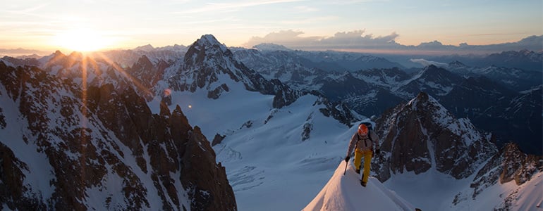
Ueli climbing Lobuche Peak. © Ueli SteckAfter arriving in Nepal’s Khumbu Valley two weeks ago, Ueli Steck has been having a blast running, climbing, bouldering and camping out while acclimatizing to the higher altitude. He and his climbing partner Colin Haley are preparing to climb Nuptse, a 7861 m mountain only 2 km away from Everest. No one has successfully climbed Nuptse via its highly technical south face since Valeri Babanov and Yuri Koshelenko first did it in 2003.
Click here to read more about why Ueli wants to climb Nuptse via its difficult south face
After completing his #82Summits project over summer, Ueli is "super motivated". © Ueli Steck
Ueli and Colin intend to climb it in the far more challenging alpine style, which means a one-time single push climb, without leaving fixed ropes. Ueli says he has acclimatized and is ready to climb. “Yesterday, I ran up Lobuche Peak from Dzongla,” he says. “It was pretty nice exercise. Summiting a 6000m peak in running shoes is quite fun!”
Click here to read about how Ueli has progressed as an alpinist
The view from Lobuche east where Ueli camped for two nights. © Ueli Steck
Ueli is waiting for Colin to get acclimated. The well known American climber experienced some altitude sickness and went down to Deboche village to recover. While he waits, Ueli has been having a good time in Dzongla. He also camped for two nights on Lobuche Peak. “It’s very nice to be back in the Khumbu Valley,” he says. “It’s great to see that life is going on for the Sherpas [after the earthquake]. “There are only a few tourists in the area so it’s quite calm.”
Stay tuned for the third part of our series on Ueli's Nuptse expedition: climbing Nuptse's south face

Ueli Steck to climb Nuptse in Nepal
Suunto ambassador Ueli Steck is soon heading to the Himalaya to climb Nuptse, a 7861 m monster in Nepal only 2 km from Everest. Follow our four-part series about Ueli and climbing partner Colin Haley’s journey as they acclimatize and make their one time push to the top.
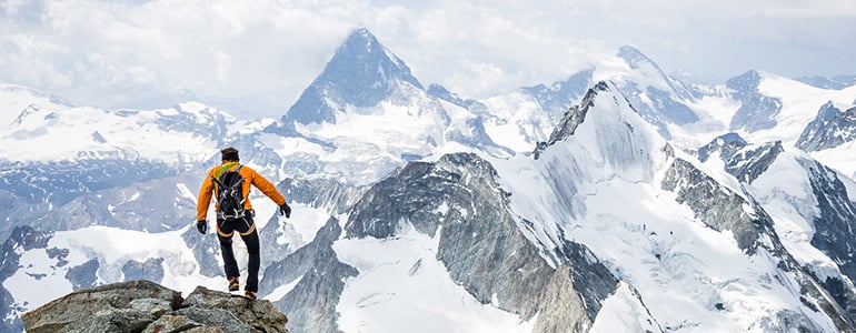
After climbing 117, 000 vertical meters in the Alps this summer for his #82Summits project, Swiss alpinist Ueli Steck is “super motivated” to take on a grande mountain. In one week the Swiss Machine – famous for his lightning fast solo ascents – is travelling to Nepal to begin acclimatizing for an alpine-style attempt on Nuptse, via its formidable south face.
Click here to read more about Ueli Steck© Jon Griffith Ueli is drawn to Nuptse because the south face reminds him of the Grand Jorasses north face, one of the most famous walls in the Alps – a highly technical climb Ueli has done several times. But, while the Grand Jorasses north face towers 1200 m above the valley below, the south-face of Nuptse is 2500 m and 5 km wide. In 2003, Russian climbers Valeri Babanov and climbing partner Yuri Koshelenko made the first successful ascent of Nuptse via its south-face, using fixed ropes. For this they won the prestigious Piolets d'Or award. However, it came hard won – for Valeri the successful ascent followed three consecutive failed attempts in two years. Since Valeri’s ascent in 2003, no one has again summited Nuptse via the south-face. “It’s never been repeated because it’s a really hard route,” Ueli says. “It’s a really technical route. That’s why I want to go there –it’s another step for me in developing technical, high altitude climbing.”
© Jon GriffithUeli believes Nuptse will be more difficult than his famous 2013 solo ascent of Annapurna, one of the most dangerous mountains in the world. That climb won Ueli the Piolets d'Or award in 2014.“I think it’s definitely harder than Annapurna south face, technical wise,” he says. “The route I did on Annapurna looks insane, but technically it wasn’t hard.”Ueli is also motivated by the fact that no one has done a successful high altitude, technical climb in the Himalaya in the alpine-style.“The true alpine style means you don’t leave fixed ropes, you carry everything on one single ascent,” Ueli explains. “It’s a single push climb – you cannot go up part of the way, come down again and then go back up.”
Whereas Russian climber Valeri Babanov and partner used fixed ropes, Ueli and climbing partner Colin Haley won’t be. “It’s going to be interesting to repeat that route in more of an alpine style,” Ueli says. “Sometimes it’s really cool to realise what other people have climbed. “The fact that someone did it before, means I have much more knowledge, which means I can climb harder because of that knowledge. “I know Valeri very well and for me it’s an honour to repeat one of his routes.”Ueli and Colin will spend about two weeks acclimatizing to the higher altitude on the north face of 6440 m Cholatse. Ueli expects the ascent and descent of Nuptse to take between four and five days.
Stay tuned for the second instalment in our four part series. Part 2: acclimatizing.
Main image credit: © Jon Griffith


Take a ride around Mont Blanc
Mont Blanc is the highest mountain in the Alps and cycling around it offers mind-blowing views. Press play on the video below and experience what it's like to ride through this incredible landscape!
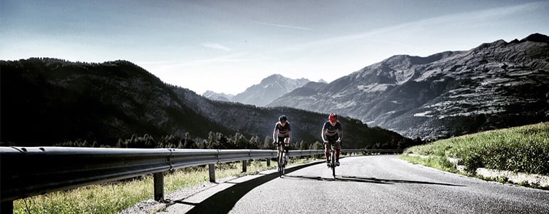
Alpinists and ice climbers Matthias Scherer and Tanja Schmitt can’t get enough of the mountains. Whether, it’s winter or summer, their lives revolve around preparing for and going on big adventures. To help them physically and mentally prepare for the coming winter, they cycled around Mont Blanc in less than 24 hours. Below, Tanja Schmitt recounts their big day out pedalling.
By Tanja Schmitt
The Tour du Mont Blanc climbs more than 8050 vertical meters over a total distance of 340 km. The route goes through some of the most beautiful alpine passes in the Alps and some of the most spectacular parts of Italy, Switzerland and France. It offers stunning views of the snow-covered flanks of the mighty Mont Blanc (4810m), the highest peak in the Alps.
As mountaineers and ice climbers, the psychological part of our sport has a big impact and the physical demands are also high. Next to basic strength training, regular rock-climbing and dry tooling, endurance training plays a major role in our overall training. For this reason, over summer Matthias and I do a lot of vertical ascent training through mountain running and biking. The idea of cycling non-stop around Mont Blanc was born from the logical step of connecting the passes and roads we’ve gotten to know so well through our training and traveling over the years. And on Sunday, August 30th the time had finally come to take action.
Click here to read more about Matthias Scherer and Tanja Schmitt
With bright headlamps and equipped with several Clif Shot Gels, Clif Shot Bloks and Clif Bars, together with salt-tablets and water, we hit the road at Aymaville and cycled along the empty roads of Aosta towards Grand St. Bernard. Our heartbeat was regular and we cycled in a steady rhythm. Our route lead us from the Col du Gr. St.Bernard over Champex to Martigny. Then over the Col de la Forclaz and on to Chamonix, Le Fayet and St. Gervais to Megève. From there we gained 750 vertical meters to les Saisies and further on to Beaufort. Temperatures during the day went to over 30° C and, correspondingly, the cycling became tougher. On the Cormet de Roselend, I began to suffer from the heat due to an agitating dry cough. But as the evening freshness came on, we got our strength back and enjoyed rolling down the long descent to Bourge-St-Maurice.
The challenge to organize water refills became an unexpected issue. However, after a nerve-racking 30-minute wait in the queue of a nearby McDonalds, we rehydrated and furthermore equipped ourselves with an ice-filled cola! The last verticals up the road of Petit St-Bernard were tackled at dawn. Then the end was in sight and after a spectacular ride down the Col to Prè-St-Didier, we felt like we were flying on the last flat kilometers on the SS26 to Aymaville. On arriving back in Aymaville, our Suunto Ambits showed a time of 19h55min. A wonderful training day in the mountains had come to an end.

24h cycle tour around Mont Blanc
It’s 7000 m of elevation gain and 300 km and ice climbers and alpinists Matthias Scherer and partner Tanja Schmitt aim to cover their Tour Mont Blanc in less than 24 hours.
It’s the highest mountain in the Alps and cycling around the base of Mont Blanc takes most people around five days. Matthias Scherer and Tanja Schmitt aim cycle it on racing bikes in less than 24 hours this Sunday.
© Matthias Scherer
They’ve been climbing mountains and frozen waterfalls for over 15 years together and for them Mont Blanc – with its stunning ice channels and snow covered flanks – is a symbol of their shared passion.“Mont Blanc for me is something like a church,” Matthias says. “When I see it, it reminds me there’s something higher and more important in life to long for than numbers and training.”The unsupported tour will be the ultimate test of their bodies and minds before autumn arrives and their ice-climbing season begins. The most challenging part, however, will be staying focused and fueled.“You have to be extremely concentrated the whole time,” Matthias says. “The descents are very tricky, the roads aren’t always good, as they have holes. “You have to stay fueled if you want to keep a rhythm.”
© Matthias Scherer
They’ll be drinking water every 10 minutes, taking electrolytes every 13 minutes, eating energy blocks every 20 minutes and sandwiches before each long downhill to allow enough rest time for digestion. Another challenge is making sure they don’t push too hard too early on in the tour. “At the beginning of a big tour like this it’s common to be a little bit euphoric and to push too hard,” Matthias explains. To avoid this, they will use their Ambit3 Peak watches to ensure they keep their heart rates at 70 per cent of their maximum. They’ll also use their watches to record their elevation gain and for GPS tracking to navigate the few stages of the tour they’re less familiar with.“It’s going to be a long training day for us, but I don’t expect to be broken,” Matthias says. “I plan to go climbing right away on Monday.”

How were the 82 summits, Ueli Steck?
How many of 82 peaks had you climbed before?
Not sure, but not too many. I had never climbed the easier mountains before.
Climbing Les Droites. © Ueli SteckWhat did the #82Summits project teach you?
That it’s all about motivation. I was surprised how long I could keep going without stopping or having rest days. It’s different to an expedition because I was moving almost everyday. That was great. I was so motivated that even on rest days I went for a run!
What three words would you use to describe #82summits?
Passion. Friendship. Fun.
What were some of the most unforgettable moments of the summer?
There were many great moments. The last one was on Barre des Écrins, in the French Alps. I ran up the wrong valley in the morning. Instead of taking the trail to Glacier Blanc, I went to Glacier Noir. There was a sign I read and I was sure the trail to Glacier Blanc was on the left. It felt strange, but I kept going. I ran for another two hours before reaching the end of the valley. By then it was daylight and I realized I wasn’t where I should be. I checked Google Maps and figured out I was on the wrong side on the mountain. I ran back down and after 3h40 minutes I was back in the valley from where I started my ascent again. So I did a little extra to warm up!
Ueli and wife Nicole on Fiescherhorn. © Ueli Steck
When was the project at its hardest?
Mentally, it was the hardest in the beginning. You start and there are still so many peaks to climb!
You started the project with Michi Wohlleben, but didn’t finish with him. What happened?
Michi crashed his paraglider descending from the Schreckhorn Hut in Switzerland. Afterwards he tried his best, but couldn’t continue.
Aiguille Blanche de Peuterey. © Ueli Steck
How did losing your partner early on change things?
It was a difficult moment. What could I do? I didn’t want to give up so easily. That’s not my personality. I would never forgive myself. So I kept going and it turned out great. It was so much fun to climb with different partners and to do solo climbs. I still have very great memories of climbing with Andreas Steindel, a mountain guide and member of the Swiss Ski Mountaineering Team. Climbing with my best friend and supporter Daniel Mader and, of course, also the summits I climbed with my wife, were all great experiences. I also enjoyed solo climbing some peaks.
How were the cycling stages of the project?
This was something new to me. On the last part down from Massif des Écrins, I really felt the magic of cycling. Going over Col du Galibier, an iconic section on the Tour de France, is a great memory. And after so many kilometres your butt doesn’t hurt anymore!
A rainy day didn't stop Ueli having fun cycling over Col du Galibier. © Ueli Steck
If you had to choose, what were some of your favourite peaks?
1. Red Pillar of Brouillard, on the Brouillard flank of Mont Blanc, in Italy
2. Dent du Geant-Grandes Jorasses Traverse: multiple 4000 m peaks on the border between France and Italy
3. Monte Rosa Traverse: 18 peaks in one day
4. Finsteraarhorn, Switzerland with my wife
5. Aiguille blanche de Peuterey, Mont Blanc massif, Italy with Jonathan Griffith
In some of your Facebook posts you refer to the pioneers who did the first ascents on these peaks. Was there a historical side to your project as well?
It was great to be on all of these routes. Sometimes you think about the people who did the first ascents and you realize that what these guys achieved was just incredible!

Here's what recovery really means
We all know proper recovery is an essential part of any training regime, but what exactly happens in our bodies while we rest, how does it impact our performance and how can new recovery features released to Ambit3 watches support our recovery? To get the answers on the science of recovery, we talked with Tero Myllymäki, who leads the physiological analytics development at Firstbeat Technologies.
Tero, can you talk us through how recovery impacts our performance?
The role of recovery is not only crucial to an athlete’s development, but to overall health and wellness; without sufficient recovery, it is impossible to build one’s endurance and stamina. In sports, the whole exercise philosophy is based on the fact that while exercising, body balance, so called homeostasis, is placed in a state of imbalance which lowers our body’s performance level. By taking the time to rest (referred to as “recovery”), this performance level is gained back, and, thanks to this recovery process, it is possible to gain a higher performance level.
What about the role of a good night’s sleep?
A really important fact in recovery is the need for a good night’s sleep. Sleeping well at night is really crucial to recovery, since it is a repetitive, long period of time, during which all body functions can relax. If recovery is successful, all the stress caused by strenuous exercising, along with other factors in your daily life, is reset at night (while you rest), and the body’s resources are replenished. Body stress and recovery can be compared to batteries: you can only use them or charge them once in a while.
Suunto Ambit3 watch offers two tests for measuring my recovery level, but what are the tests measuring in practise?
Recovery is analyzed by measuring the body’s autonomic regulation balance through heart rate variance. At night, one would expect the parasympathetic (so-called relaxing body function) to be powerful and thorough enough to activate the body’s recovery processes. Recovery measurement tests determine how calm a person’s body is during sleep.
How does this information benefit an athlete?
Monitoring this recovery can make the time used in exercising more efficient, because it is good to know when you can exercise on full speed, and when you should take it more slowly and simply let your body recover. Recovery measurement tests will also tell you when you are training too hard, or when you should work harder, so that an athlete can measure the risk of exercising too hard, or not exercising at all. Recovery monitoring is a learning process for you; it enables an athlete to reflect on how he/she is feeling.
What about muscle pain or flue, will the recovery test recognize these?
Even though the autonomic regulation has regained normal levels, intense or abnormal exercises done by an athlete might cause muscle damage, as well as risk to the overall body energy levels. These situations cannot be monitored via autonomic regulation tests. Weakened muscle level recovery can be seen during the exercise, although you wouldn’t be able to see it in the recovery tests. Instead, the effect of diseases such as fever which affect the overall body regulation system, can be seen in the autonomic regulation activity, and, consequently, from the recovery test data.
Can I analyze my sleep quality with the test?
Sleeping badly, and/or waking up during the night can be regarded as a side-effect of the body refusing to slow down, and the heart’s autonomic regulation and/or parasympathetic regulations are weak. This also lowers the recovery levels. The quality of your sleep is influenced by many different factors, and sometimes it may indicate how a person feels about his/her sleep; other times, it may be a direct result of the electrical impulses in the brain which measure sleep phases. Recovery measurements won’t directly measure these sleep phases, but it can reflect on it by measuring autonomic regulation (how relaxed the body is).
Read more about the features: Tutorial Tuesday: Learn how to use Ambit3's recovery features
Tero Myllymäki, M.Sc., Physiology Research, Firstbeat TechnologiesMr. Myllymäki is responsible for physiological analytics development and research collaboration at Firstbeat. He possesses an academic background, and previously worked as a researcher in several multidisciplinary expert teams, combining physiology, psychology, and technology. His goal is to seek innovative solutions for providing meaningful and actionable feedback on well-being, lifestyle, and performance in daily life. Mr. Myllymäki has a Master’s Degree in exercise physiology from the University of Jyväskylä.
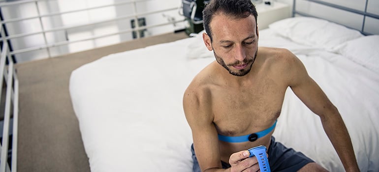
Get to know your recovery status with Ambit3 watchSuunto Ambit3 watch offers two ways to follow your recovery. The quick recovery test and the sleep recovery test both measure your heart rate variability to give you an indication of your recovery status in percent. The higher the percentage, the more recovered you are. The tests require a Bluetooth Smart compatible heart rate sensor that measures heart rate variability (R-R interval), such as Suunto Smart Sensor.
The quick recovery test is performed by wearing the Smart Sensor belt for three minutes and then checking the recovery percentage from the Suunto Ambit3 watch. Alternatively, you can run the sleep recovery test which measures your heart rate variability through the night to give you an accurate indication of your recovery status in the morning when you wake up.


