


Suunto Blog


Get key info at a glance with the new Outdoor watch face
The new Outdoor watch face for the Suunto 9 Baro, 9, 5 and 3 watches allows users to track conditions and daylight hours with just a quick glance. No need to press buttons or scroll – the essential info is presented on the screen.
Suunto UX designer Jeanette Lau supported the development and says the motivation behind the watch face was to support users with their adventure planning. “We wanted to inspire and equip users for their outdoor adventures,” she says. “We conducted some research and we learned many of our users felt as if there wasn’t enough time in the day and wanted to know what the conditions were before embarking on their adventure.”
Click to learn about 8 tools to track the weather with Suunto
For all of the above watches, the Outdoor watch face features a sun gauge that displays the number of night and daylight hours before sunrise and sunset. Tap the screen once, and the watch face displays the number of hours until sunset or sunrise, plus the battery life remaining, or the moon phase, which is helpful because on a full moon night you know you’ll have extra light to stay out a little longer.
“Most of the time we feel as if there isn’t enough time in the day,” Jeanette says. “But with this watch face, I can see exactly how much time I have for a run before the sun sets without having to do the math myself.”
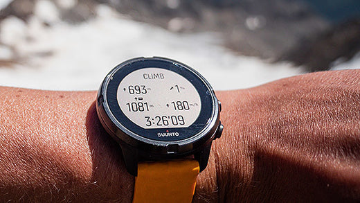
On the Suunto 9 Baro
On Suunto 9 Baro watches – which have a barometer – the Outdoor watch face also displays an air pressure gauge along with current altitude. With two taps on the screen, a more detailed screen appears, displaying the barometric trend and, once they are 2000 m or higher, the oxygen percentage.
On the Suunto 9, Suunto 5 and Suunto 3
Rather than extra barometric info, on the Suunto 9, 5, and 3 watches, the Outdoor watch face includes a steps gauge that quickly tells users where they’re at with their daily step goal and how many calories they have burned.
To get the outdoor watch face on your Suunto 9 Baro, Suunto 9, Suunto 5 or Suunto 3, make sure you have the latest software version on your watch and then enter the watch face selection in your watch settings and choose the newly loaded face.
Read more articles
8 tools for tracking the weather with Suunto

Boost your hill training with SuuntoPlus Climb
Hill repeats are an essential part of an outdoor athlete’s workout repertoire. To make the hard work pay off, pacing is key. The new Climb SuuntoPlus™ feature does just that: it gives you real-time insights on your effort and motivates you to keep going.
The same goes for longer hikes, too: once you learn what kind of ascent speeds are sustainable for you, you can use this feature to pace your way up accordingly.
To use SuuntoPlus™ features on the Suunto 9 or Suunto 5, activate them before starting an activity: Select your preferred activity type and – before hitting start – go down to the options menu and select your preferred SuuntoPlus feature, like Climb. The SuuntoPlus feature you chose, will be added and available as an extra screen during the session.
© Philipp Reiter
Top left: Ascent and climb counter
After you have activated SuuntoPlus Climb your watch will automatically detect the uphills and also create laps of them. The first climb is triggered after ascending for 10 meters.
During the climb you will see the ascent you have covered during that particular uphill on the top left on your screen. Once the climb ends, the ascent number will switch to the total number of climbs you have covered. When the next climb starts, you will again start to see the vertical meters for that individual climb.
Top right: Grade %
On the top right you have the grade of your uphill in percentages. The same goes for the downhill, too. The arrow shows the direction of the hill. The grade is based on your progress during your recent efforts.
Bottom left for running: Normalized Graded Pace
During trail running and running your running speed is shown as Normalized graded pace (NGP). Normalized graded pace is the adjusted pace, that reflects the changes in grade and intensity that contribute to the physiological cost of running on varied terrain.
Bottom left: Total vertical meters
For activity types other than running this view shows the total vertical meters covered during the activity.
Bottom right: Vertical speed
Vertical speed is a great way to pace an effort in an uphill lap. This also helps you estimate how long the climb will take for you – if you know the total ascent. The vertical speed is shown as meters per hour.
Note: SuuntoPlus Climb works best with watches that have a barometric sensor, like Suunto 9. Products without a barometer rely on GPS based altitude. This will require longer climbs as small changes in elevation may not be identified.
Lead image: © Philipp Reiter
Read more about hill repeats
7 tips to accelerating your uphill speed
Improve your running with high intensity hill repeats

Six ways to plan a route for your next adventure
An essential part of outdoor adventure is planning. The better you are at it, the smoother, safer and more relaxed your trips.
Of course, there are many aspects to planning, from understanding the topography and distances, through to knowing your group and managing rest breaks. However, knowing your route is key. When that’s sorted everything else is more likely to flow.
Whether you want to start from scratch, use an existing route or something in between, here are six different ways to create a route for your Suunto watch to guide your next adventure.
Suunto app’s route planning capabilities are very versatile. Depending on the situation you can use the most suitable option – even on the go as all these work on your mobile.
Planning a route from scratch is just one of the many route planning options on Suunto app.
Plan a route from scratch
Just opening the map and starting to draw your own route is probably the first route planning method that comes to people’s minds. Just mark the starting point and key points along the way to draw the desired route to your destination.
Tip: To help the route planning process you can choose whether you want to follow “any road or path”, “all road types”, “all road types avoiding hills”, “paved roads” or “free drawing”. Using the most suitable option will make planning more efficient.
Plan using heatmaps
Suunto Heatmaps show the tracks frequently used by Suunto community all over the globe, based on millions of activities. Turn the heatmaps on and choose the desired activity type. Suunto heatmaps are sport specific. This allows you to differentiate between activities, for example, running and trail running. Heatmaps can be on while planning routes. This enables you to see where the popular trails are.
Tip: Suunto app also has “My Tracks”, a new feature showing where you have been during the last week, month or a year. Compare your own tracks with the general heat to spot areas and trails you haven’t yet been to.
Suunto app recommends popular routes for your location.
Use popular routes on Suunto app
When browsing Suunto app’s map view, you can swipe up a menu of route recommendations: the app automatically generates popular routes for the location you have selected. Simply select an activity type, see what others have been doing and select one you like.
Tip: If you want to see more route options, zoom out or change the location for your search and tap ‘Search here’.
Use an existing activity
Would you like to do that awesome run from last year again? Or has your friend been to an interesting trail? You can use existing activities to create routes. All you need to do is tap the three dots on top right of the activity screen and select ‘Save route’. The route then opens in Suunto app’s route planner so you can name the route and sync it to your Suunto watch.
Tip: If you want to find your old activities more easily,, add a trail name, location etc in the description field. You can then search for them in your Diary on Suunto app and create routes for navigation.
You can sync routes to Suunto app from Suunto compatible route services, like Wikiloc, and get access to their planning tools and route libraries.
Sync from a partner service
Suunto app is compatible with several route planning services, like komoot, Fatmap, Wikiloc, Twonav Land, Openrunner and2bulu (in China). Connect your Suunto app account with the partner service to get routes created there to be synced with your Suunto app – and your watch. You can find thousands and thousands of routes in the partner services and also use their tools, like route libraries, desktop apps and big screen solutions. (Learn more about Suunto's partners.)
Tip: Some of our route service partners are included in Suunto Value Pack. Learn more about it here.
Import a GPX file
Have you spotted an interesting route in the media or perhaps a race organizer has offered you the race route as a GPX file? To get that route on your watch, save it in a location you can access on your phone and open it using Suunto app. (Learn how to import a GPX file on Suunto app for iOS or Android.)
Tip: You can also share or save your own routes as GPX files using Suunto app: Go to the list of your routes and click the sharing button. Then select whether you want to share the route or save the GPX file.

A veteran navigator’s 9 tips for staying on track in the mountains
The first two articles (here and here) in this series on way-finding were about skills and preparation. In this one, our resident navigation guru Terho Lahtinen take the training wheels off. Now he distills the essentials to stay on track when you’re on an adventure out in the backcountry.
Terho has been map reading and navigating since he was six years old, when his father taught him. His love of the outdoors grew in the Boy Scouts, and eventually he competed in orienteering at the national level for Finland for more than 20 years, and was lead navigator for adventure racing team Salomon X-Act which competed around the globe for eight years.
“Mountain sports took on a bigger role in my life while adventure racing,” Terho says. “I was the lead navigator in our team. Nowadays, I’m hiking, biking and ski-touring in the mountains as often as I can get away with.”
Clearly explain the route ahead to your group. This ensures everyone learns. © Arc'teryx / Piotr Drozdz
Do a gear check
You’ve just parked at the roadend, get out of your car, and gaze up at the mountains around you. You and your group will be alone there. It’s time to get locked in.
First things first: check you have all the essential gear packed. The right maps, head torches, first aid kit, your trusty Suunto 9 or other GPS, maybe your avalanche safety gear, and that all electronic devices are fully charged.
Brief the group
Before charging up the trail, get your group together and hold a short briefing. This ensures everyone is on the same page and means less questions or confusion later. Talk about your intention for the trip, for example to stay safe, have fun, and be patient with one another.
Then do an overview of the days ahead; where you are going, distances each day, points of interests, and where you’ll be sleeping. Lastly, preview the day ahead, the first leg of the day and what you will be encountering, and when you’ll be having lunch.
Remember to factor in breaks and toilet stops. Photo by Ted Bryan Yu on Unsplash
Keep a schedule
Knowing what you should encounter on each leg of your trip is the key to staying on track. Terho advises scheduling check points (to reach specific locations at particular times), consider safety margins, and when to turn back or change plans, perhaps due to tiredness, darkness, or inclement weather. Review the second article in this series to consider pace and average travelling time. Pause for a few minutes between legs, look at your map, and identify what’s coming up.
“It’s good to have an overall idea of the day, and a more detailed understanding of the next logical leg of the route (usually a few kilometers or the next hour or so),” Terho explains. “Always identify the next clear navigation point you are aiming at to make sure you are staying on the planned route.”
Use handrails
Handrails are distinctive, guiding terrain features that can guide you to your destination. For example, you might go off trail in a certain direction until you reach a creek you’ve identified on the map. Then, you might use the creek as a handrail to find a bridge.
“Suitable handrails are hills, ridges, contours, ditches, lake sides, rivers, or any other long terrain feature that take you towards the desired location,” Terho says. “Be sure you follow the hand rail in the right direction!”
Aim with landmarks
In addition to hand rails, you can also use distinctive landmarks near your next destination as navigation aids.
“Instead of trying to directly find your destination, identify a clear terrain feature on the map that’s near your destination and find that first,” Terho says. “Then you’re sure to get close to where you want and then use more detailed navigation for the last part of the leg.”
The direct route isn't always the fastest route. Study the terrain. © Arc'teryx / Piotr Drozdz
Test your memory
Building on the previous two tips, Tehro suggests you test your memory to see what you recognise. First, review the plan for the next leg of your journey. Look at your map and identify the handrails and distinctive features or landmarks you should see on the way to your next destination. After getting a handle on that, put away your map and follow your plan to the next destination. How many times do you need to look at the map?
“Mentally visualizing the upcoming route in advance and memorizing the essential features, trail forks, points of interest, is a useful technique,” Terho explains. “It helps you to recognize those locations on the go and gives you freedom to put your map or navigation device away and enjoy the surroundings and the activity itself.”
Be willing to hit pause
If you start to get the feeling you have gone astray, don’t keep going. Pause and gather yourself. One of the things that gets people in trouble in the backcountry is when they go off course there they double down and keep moving forward rather stopping, taking stock, and turning back if need be.
“If you are uncertain, stop and check the location with your map,” Terho says. “If you don’t know where you are, don’t continue until you find it out.”
Technology rocks
While for way-finding purists, navigation should only involve a map and a compass, let us speak honestly here; technology is awesome and makes things easier for many of us.
“If you upload your planned route to the GPS in advance, you can immediately see from the screen if you are off course and where the right course is in relation to your current location,” Terho says. “Most GPS also have an off-course alarm, notifying you if you left the intended path.”
A Suunto 9, or other GPS device, includes an altimeter, which is a useful navigational support. It tells you your current elevation to help you identify where you are on the map. You can then stay at the correct elevation for your course. For example, as you cross a mountain saddle.
Getting back on track
In the event you do go off course, remember that not knowing exactly where you are is not the same as being lost. It’s important to stay calm if you realize you don’t know your location. Take a break, sit down, and think things through.
“Start off by spotting landmarks around you to match them with the map,” Terho advises. “Think about where the last point was on the map where you knew where you were, and how long ago, in terms of time, that was. Work out how far you have traveled since then, what you’ve seen around you, and where you might have ended up. When you identify your location, plan the best option to get back on track.”
You have three options: You can follow your track back to the point where you made a wrong turn. Alternatively, you can follow a new route to get back to your planned course. And lastly, you can follow a new route directly to the next destination.
“The tactic you choose depends on the terrain, the skills and experience of your group, and the time of day,” Terho says. “If you are losing light, or in rugged terrain, always take the safest option.”
Stay tuned for the final article in our series on way-finding: Tips and tricks for handling challenging situations in the mountains.
Lead images:
Photo by Krisjanis Mezulis on Unsplash
Photo by Fabrizio Conti on Unsplash
Read more articles:
How to find your way in the mountains7 tips to plan a route in the mountains8 avalanche safety checks to tick off before the ski season7 tips to find a safe route up the mountain

World Vertical Week 2020 Big Data: The nation that climbed the most is …
Well done to everyone who got out there and chased vertical meters over World Vertical Week 2020. We saw some inspiring efforts from people around the world.
Two firefighters, for example, donned their heavy protective clothing and gear, and powered up and down the best training hill in their hometown of Helsinki, Finland. That’s going above and beyond the call of duty! Read their and two other cool stories from the week here.
At Suunto HQ we are always excited to analyze the data and see how much our users have climbed over the week, and which nations and sports have sweated it out and gathered the most vertical meters. This year week has some exciting results.
Over time, World Vertical Week has gradually been becoming a tradition; more and more people are participating and sharing their love of moving uphill.
Return to the top
Last year, one of the surprise results was that Austria lost it’s top place as the nation that gains the most vertical meters by average after holding it for two years. This year, the alpine nation has retaken the throne. The average climb among Suunto users in Austria was 457 m. Sehr gut Österreich!
Notable mention to second place Switzerland (418 m) after dropping to eighth place last year. In the previous two years before that it was near the top. Italy (395 m) came third. These results prove once again that alpine nations know the best way to move is upwards!
The overall kick ass nations
Respect to our users in Italy, Spain, Austria, and France, all nations that came in the top five of five or more categories. Italy landed in the top five of 10 different categories, and Spain landed in the top five of seven.
Skimo the go
No surprises here; once again ski mountaineering accumulated the most vertical meters (838 m) on average out of all our activity types. Mountaineering (545 m) and trail running (466 m) came in second and third, as they did last year.
Race to the top
In the race for most total ascents per country, France beat out Spain to win the country that climbed the most. Last year, Spain came out on top. And, once again, Italy came in third.
Impressive individual efforts
There were 1772 participants who climbed more than a thousand meters during the week, and 1095 individual sessions that included more than 1000 meters of climbing. That’s some solid training, folks. Well done!
Top nations by sport
Ski touring
No nation cracked the 1000 m mark this year in the skimo stakes, but it’s clear many users are gunning for this. Keep pushing and nail it next time!
1. Spain 972m 2. Austria 948m 3. Italy 946m 4. Switzerland 921m 5. Slovakia 903m
Mountaineering
Kudos to Sweden, a small nation of 10 million, for coming out on top in the mountaineering category, and for breaking the 1000 m mark. Surprising given last year it didn’t even make the top five.
1. Sweden 1316m 2. Italy 1060m 3. Austria 666m 4. Spain 581m 5. Slovenia 494m
Trail running
People in Asia are crazy about trail running, and once again Asian nations won the podium this year and four were in the top five. Nice!
1. Japan 932m 2. Hong Kong 896m 3. Thailand 676m 4. Greece 649m 5. Malaysia 636m
Mountain biking
Austria won this one, followed by Spain and Italy; all nations in the top five last year, too.
1. Austria 582m 2. Spain 513m 3. Italy 469m4. Switzerland 375m 5. France 356m
Trekking
Notice anything? This time Italy wins and Spain and Austria follow.
1. Italy 559m 2. Spain 397m 3. Austria 375m 4. France 352m 5. Malaysia 316m
Hiking
Malaysia came out on top here, and, as a side note, also came in fifth place for both trekking and trail running. We can imagine exploring the incredible mountainous rainforests in Malaysia must be pretty motivating!
1. Malaysia 606m2. Italy 475m 3. New Zealand 453m4. Slovenia 352m5. Japan 343m
Nordic skiing
Go Canada! Last year Canada came second, behind France. This year they reversed positions.
1. Canada 438m2. France 268m3. Norway 233m4. Austria 218,0m5. Italy 217,6
Cycling
Portugal won after not even making the top five last year. Spain, Italy, Israel and South Africa once again filled the rest of the positions.
1. Portugal 460m 2. Spain 390m 3. Italy 345m 4. New Zealand 316m 5. South Africa 310m
Running
This category had very narrow margins between nations, and a slight reduction in average meters from last year. Last year New Zealand won it. Congrats Norway!
1. Norway 156m 2. Switzerland 151m 3. Czech Republic 142m 4. Italy 140m 5. France 139m
Lead images:
Photo by Klemen Tušar on Unsplash
Photo by Jamie Davies on Unsplash
Read more articles
On the rise: top stories from World Vertical Week 2020
How to find your way in the mountains
7 tips to accelerating your vertical speed

On the rise: top stories from World Vertical Week 2020
© Philipp Reiter
World Vertical Week has become an annual tradition, and many Suunto users are finding creative ways to get the most out of it.
The week is really an invitation to get outside, to push oneself, and find new resolve and strength. It’s also a chance to show that nearby hill or mountain who’s boss.
This year, we again ran a World Vertical Week photo competition with three lucky people winning a Suunto 7 or a Suunto 9. We asked our Instagram followers to share an image with a Suunto app data overlay from one of their ascents over the week and tag #verticalweek. We received so many inspiring entries. Thanks to everyone who participated. Check out the winners and their shots below. Congrats!
Firemen to the rescue!
Two firemen in Finland went above and beyond the call of duty for World Vertical Week. Henri-Aleksi Pietilainen, 29, and his room mate at the Rescue Academy showed their dedication by donning their protective fire gear and ascended the most popular training hill in Helsinki multiple times – and just after finishing a 24 hour shift. Respect guys!
“We thought it was going to be easier (considering my level of training in the mountains and my friend’s latest expedition through Greenland), but the extra 25 kg of weight and unforgettable clothing and gear gave a nice extra ‘touch’ and was really good training,” Henri says. “We did this in a pair because in real firefighting rescue missions it’s good to have a partner to help each other out.”
Cooking up a storm
It was Lukasz Bodaszewski’s first time participating in World Vertical Week. The 39-year old chef from Poland runs a catering company with his wife in the French Alps. He aimed to ascend 3000 m over the week, and managed 2300
“But I finished 1000 m in one day and I’m proud of that,” he says. “Vertical Week was good timing because I’m training for the 160 km Val d’Aran UTMB in the Pyrenees and for 145 km TDS at UTMB this year, so it was good to have a specific climbing week.”
Getting out there
Casey Sackett didn’t hold back for World Vertical Week. From Hurricane, Utah, Casey aimed to achieve a mile of vertical gain (1610 m) over the week. He notched up a total of 1631 over a series of awesome trips, including mountain biking the Gooseberry Mesa and the rest what he refers to as “desert alpinism” (alpine style lines in a desert ecosystem).
“Conditions were perfect all week out here and gave me the opportunity to get out every chance I had!” Casey says. “My favorite push was my last one, trekking/trail running up a mesa to the La Verkin Overlook. My eight-year-old daughter set the pace on the 4 km ascent with almost 243 m of gain. We did it in just 61 minutes! Her endurance blew me away, so proud!”
Thanks again to everyone who got out there and pushed their comfortzone for World Vertical Week. Keep it up!
Lead images: © Philipp Reiter
Read more articles
The nation that climbed the most in World Vertical Week is ...
7 tips to accelerating your vertical speed
How to find your way in the mountains


