


Suunto Blog

A veteran navigator’s 9 tips for staying on track in the mountains
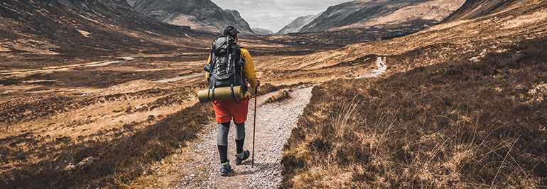
The first two articles (here and here) in this series on way-finding were about skills and preparation. In this one, our resident navigation guru Terho Lahtinen take the training wheels off. Now he distills the essentials to stay on track when you’re on an adventure out in the backcountry.
Terho has been map reading and navigating since he was six years old, when his father taught him. His love of the outdoors grew in the Boy Scouts, and eventually he competed in orienteering at the national level for Finland for more than 20 years, and was lead navigator for adventure racing team Salomon X-Act which competed around the globe for eight years.
“Mountain sports took on a bigger role in my life while adventure racing,” Terho says. “I was the lead navigator in our team. Nowadays, I’m hiking, biking and ski-touring in the mountains as often as I can get away with.”
Clearly explain the route ahead to your group. This ensures everyone learns. © Arc'teryx / Piotr Drozdz
Do a gear check
You’ve just parked at the roadend, get out of your car, and gaze up at the mountains around you. You and your group will be alone there. It’s time to get locked in.
First things first: check you have all the essential gear packed. The right maps, head torches, first aid kit, your trusty Suunto 9 or other GPS, maybe your avalanche safety gear, and that all electronic devices are fully charged.
Brief the group
Before charging up the trail, get your group together and hold a short briefing. This ensures everyone is on the same page and means less questions or confusion later. Talk about your intention for the trip, for example to stay safe, have fun, and be patient with one another.
Then do an overview of the days ahead; where you are going, distances each day, points of interests, and where you’ll be sleeping. Lastly, preview the day ahead, the first leg of the day and what you will be encountering, and when you’ll be having lunch.
Remember to factor in breaks and toilet stops. Photo by Ted Bryan Yu on Unsplash
Keep a schedule
Knowing what you should encounter on each leg of your trip is the key to staying on track. Terho advises scheduling check points (to reach specific locations at particular times), consider safety margins, and when to turn back or change plans, perhaps due to tiredness, darkness, or inclement weather. Review the second article in this series to consider pace and average travelling time. Pause for a few minutes between legs, look at your map, and identify what’s coming up.
“It’s good to have an overall idea of the day, and a more detailed understanding of the next logical leg of the route (usually a few kilometers or the next hour or so),” Terho explains. “Always identify the next clear navigation point you are aiming at to make sure you are staying on the planned route.”
Use handrails
Handrails are distinctive, guiding terrain features that can guide you to your destination. For example, you might go off trail in a certain direction until you reach a creek you’ve identified on the map. Then, you might use the creek as a handrail to find a bridge.
“Suitable handrails are hills, ridges, contours, ditches, lake sides, rivers, or any other long terrain feature that take you towards the desired location,” Terho says. “Be sure you follow the hand rail in the right direction!”
Aim with landmarks
In addition to hand rails, you can also use distinctive landmarks near your next destination as navigation aids.
“Instead of trying to directly find your destination, identify a clear terrain feature on the map that’s near your destination and find that first,” Terho says. “Then you’re sure to get close to where you want and then use more detailed navigation for the last part of the leg.”
The direct route isn't always the fastest route. Study the terrain. © Arc'teryx / Piotr Drozdz
Test your memory
Building on the previous two tips, Tehro suggests you test your memory to see what you recognise. First, review the plan for the next leg of your journey. Look at your map and identify the handrails and distinctive features or landmarks you should see on the way to your next destination. After getting a handle on that, put away your map and follow your plan to the next destination. How many times do you need to look at the map?
“Mentally visualizing the upcoming route in advance and memorizing the essential features, trail forks, points of interest, is a useful technique,” Terho explains. “It helps you to recognize those locations on the go and gives you freedom to put your map or navigation device away and enjoy the surroundings and the activity itself.”
Be willing to hit pause
If you start to get the feeling you have gone astray, don’t keep going. Pause and gather yourself. One of the things that gets people in trouble in the backcountry is when they go off course there they double down and keep moving forward rather stopping, taking stock, and turning back if need be.
“If you are uncertain, stop and check the location with your map,” Terho says. “If you don’t know where you are, don’t continue until you find it out.”
Technology rocks
While for way-finding purists, navigation should only involve a map and a compass, let us speak honestly here; technology is awesome and makes things easier for many of us.
“If you upload your planned route to the GPS in advance, you can immediately see from the screen if you are off course and where the right course is in relation to your current location,” Terho says. “Most GPS also have an off-course alarm, notifying you if you left the intended path.”
A Suunto 9, or other GPS device, includes an altimeter, which is a useful navigational support. It tells you your current elevation to help you identify where you are on the map. You can then stay at the correct elevation for your course. For example, as you cross a mountain saddle.
Getting back on track
In the event you do go off course, remember that not knowing exactly where you are is not the same as being lost. It’s important to stay calm if you realize you don’t know your location. Take a break, sit down, and think things through.
“Start off by spotting landmarks around you to match them with the map,” Terho advises. “Think about where the last point was on the map where you knew where you were, and how long ago, in terms of time, that was. Work out how far you have traveled since then, what you’ve seen around you, and where you might have ended up. When you identify your location, plan the best option to get back on track.”
You have three options: You can follow your track back to the point where you made a wrong turn. Alternatively, you can follow a new route to get back to your planned course. And lastly, you can follow a new route directly to the next destination.
“The tactic you choose depends on the terrain, the skills and experience of your group, and the time of day,” Terho says. “If you are losing light, or in rugged terrain, always take the safest option.”
Stay tuned for the final article in our series on way-finding: Tips and tricks for handling challenging situations in the mountains.
Lead images:
Photo by Krisjanis Mezulis on Unsplash
Photo by Fabrizio Conti on Unsplash
Read more articles:
How to find your way in the mountains7 tips to plan a route in the mountains8 avalanche safety checks to tick off before the ski season7 tips to find a safe route up the mountain


What you need to know about cold water swimming
With public swimming pools closed in many countries, swimming in open water ensures we keep our training moving forward. However, open water is usually colder water, especially earlier in the year.
We talked to Norseman Xtreme Triathlon chief medical and safety officer Jørgen Melau about how to stay safe swimming in cold water. Jorgen is currently finishing a PhD on cold water swimming and before starting his research he served in Norway’s Arctic air ambulance rescue operations.
“There are many benefits to cold water swimming,” Jørgen says “And although our research is focused on the dangers, I want to stress that the benefits of open water swimming far outweigh the risks. So I really encourage everyone to try it!”
Joakim Dokka Nordstad/nxtri.com
The benefits
Ask any dedicated cold water swimmer and they will tell you how amazing it makes them feel. This is probably because of the massive endorphin (feel good hormones) release swimming in cold water generates. Plunging into uncomfortably cold water stimulates our body’s pain system, which releases those delightful endorphins to help us manage it.
Cold water swimming is also touted to improve circulation, burn more calories, increase libido, reduce stress and strengthen the immune system.
The risks
When you suddenly enter cold water it strongly activates several branches of the nervous system. “These are strong and powerful activations, and for some vulnerable people, it can be very dangerous because it can generate arrhythmias,” Jørgen says. “It is called the autonomic conflict, if anyone is interested in learning more.”
The second risk is hypothermia, due to the cooling of the body’s core temperature. “Hypothermia is a problem only if the water is cold and the swim is very long,” Jørgen explains. “However, there are huge individual variations, and this is why it is so hard to give any exact limits. We do not recommend swimming in water colder than 12°C. And for some, it should probably be much warmer.”
Study demonstrates risk
In the 2015 Norseman Xtreme Triathlon the water temperature dropped to 10°C so Jørgen and the race organisers shortened the swim. A few months later Jorgen asked 20 triathletes to swim in 10°C water for a controlled study. The study showed that if Norseman had allowed a full distance swim in 2015, almost 50% of the athletes would have suffered from medical hypothermia. “This was a real eye opener, and something we believe is very important to know,” Jørgen says.
How to begin
Start with brief sessions
To give your body and mind time to adapt, start cold water swimming with brief sessions. Then as you become accustomed, you can gradually lengthen them.
Enter the water gradually
Jørgen advises not to jump or dive into cold water, but to enter gradually. “The human body is very adaptable to different environments. Yet, we help ourself a lot if we give the body some time to readjust. Enter the water slowly, taking half a minute to a minute.”
Stay active after
After exiting the water, stay active to warm up your body. “Your body is excellent in producing its own heat, and you do that by keeping your muscles busy,” Jørgen says. “So go for a run or hop onto the bike. “An additional tip is to dry off your wet skin when you have finished your swim; you waste a lot of heat if the body needs to dry your skin from its internal heat supply.”
Joakim Dokka Nordstad/nxtri.com
The Norseman open and cold water swimming code
Never swim alone
This really is essential. Before embracing adventure and bracing for the cold you need to find a buddy to share the journey to help keep one another safe. Alternatively, you can find someone to monitor your progress from a boat or by the shore.
Out on swims together, stay close and be observant of your swim buddy. If you swim in a group, always team up with a buddy, so you can look out for each other. It’s safer and more fun.
Avoid water colder than 12°C
Norseman advises people 12°C should be the minimum for cold water wetsuit swims. And for such low temperatures, the swims should be short.
“For many people, it’s probably wise to have a higher water temperature than this,” Jorgen cautions.
If you feel cold for more than 10 minutes, abort the swim, and get yourself warm. Be aware that the temperature and wind on land may pose a risk for hypothermia even after exiting the water.
In cold water, swim for 20 minutes only before exiting the water to warm up.
Plan your swim
Cold water swimming is a little like going up into an alpine environment in the sense you shouldn’t just wing it, and hope everything will be hunky dory. It’s asking for trouble
Research your swimming spot. Be aware of hazards like shallow water, tides, rip currents, marine life, or boat traffic. With Suunto App, use Suunto Heatmaps to find places to swim and ask people in the Suunto community who swim there for info.
Let someone at home know where you plan to swim and what time you will finish.Check the weather forecast.
Know your ability
To stay safe and to keep it enjoyable, make sure you have the ability and fitness to complete the swim you’ve planned. Keep an eye on the conditions; a wind change can quickly increase wave or swell size.
Under no circumstances go swimming during a thunderstorm. A lightning strike in water may be lethal.
Swim close to shore
If the conditions change or you get tired or start getting cramps, being close to shore means you can get out quickly. You are also easier to spot and help close to shore, and you avoid encountering potentially dangerous marine traffic.
Be prepared for emergencies
Have a plan in mind for what to do if anything happens to you or your swim buddy. Know exactly where the nearest phone (your swim tow, the car). Consider having a third person observing you both from shore. If there are known rips or currents in the area, know how to respond if you get caught in one. Where are alternative exit points?
Alexander Koerner/nxtri.com
Get emergency training
Practice how to help your buddies in open water, transiting him or her to shore, and getting them out of the water. This is important to know in the eventuality your buddy cramps.
Know your CPR and take a course regularly to maintain your knowledge.
Have the right gear
A Suunto watch paired with a Suunto Smart Sensor heart rate belt: These track your level of exertion, give you data about your stroke rate, time and distance, and the GPS will allow you to see post-swim whether you swam in a straight line or not. Plus, Suunto Heatmaps makes it easy to find popular open water swimming spots near you.
A swim tow float: these are an extra safety aid. They act as a flotation device in the event you get cramp or need to rest. They are brightly coloured so improve your visibility and can be used to store your car keys, wallet and smartphone.
A silicone hat or wetsuit hood. Try to find a brightly coloured hat so you are easily visible on the surface.
Goggles: Make sure they are comfortable to wear for an extended period and consider choosing polarized goggles to reduce sun glare for better vision.
Anti chafe balm: applying this under your wetsuit helps to prevent chafed and cracked skin.
Boots, gloves, wetsuit socks: these not only keep your feet and hands warm, they also prevent injury by providing some grip as you enter and exit the water.
Lead images: Alexander Koerner/nxtri.com
Read more articles
10 reasons to enjoy open water simming with Suunto
5 steps to therapeutic breathing to combat COVID-19
Blaze fresh routes


5 steps to therapeutic breathing to combat COVID-19
Suunto ambassador William Trubridge knows a thing or two about deep breathing. In 2016, he set a new world record by diving to 102 m on one breath. In 2019, he became the first man to complete an 'underwater crossing' of one of the world’s major channels, swimming across the wild Cook Strait as a series of 934 breath hold dives.
William has recently taken another deep dive, this time into the medical world and its treatment of COVID-19. Concerned about the impacts of the virus, he researched how it attacks the body and the medically accepted treatments that help people recover from it. In the process, he learned therapeutic breathing can play a valuable role. Read on for his in-depth report!
Scroll down to see William demonstrate a deep breathing exercise!
Therapeutic breathing for COVID-19
By William Trubridge
SARS-CoV-2 is a virus that targets the respiratory system. It attacks our ability to breathe. Now it’s emerging that a strategy to combat this infection may be through breathing itself.
First, I need to state clearly I am neither an epidemiologist nor pulmonologist. Everything I describe in this article has been recommended by experts (who I will reference) in one or both of these fields, and I will not speak or extrapolate beyond their recommendations. My career in freediving has meant that I have spent almost two decades harnessing the power of breathing, and I hope to use this experience to help describe and demonstrate how to achieve the recommendations of the experts.For example, the instruction to ‘breathe deeply’ is like telling someone to ‘swim smoothly’– there is a lot of technique inherent in the action. A ‘deep breath’ could have vastly different results depending on whether you start at the base of the lungs, sucking air into the belly, or if instead you simply lift the shoulders and ‘gasp’ the air in. These are the distinctions where I hope to add value.
When JK Rowling contracted Covid-19 in April, she employed a technique described by physician Sarfaraz Munshi from Queen Hospital UK that is aimed at maintaining lung function and preventing secondary pneumonia during the illness.1 The Youtube video of his description is here, and the sequence he advises can be summarised as follows:
1. Sit with a straight spine and feet flat on the floor (I add this instruction, since deep breathing while standing risks fainting).2. Breathe in deeply, hold for 5 seconds and exhale – repeat 5 times.3. Breathe in and do a big cough from the base of the lungs (covering your mouth) 4. Repeat Steps 2 & 3.5. Lie flat on your front with a pillow in front of you, taking fairly deep breaths for 10 minutes.
This sequence is taught by respiratory physiotherapists also, where it sometimes goes by the name of ‘Active Cycle of Breathing Technique.’ It is important to remember it's a therapeutic treatment, not preventative: there is no reason to expect that it will help to protect against infection with the virus in the first place.
The deep breaths help to ventilate alveoli and remove debris that has accumulated on the walls of the alveoli due to damage from the virus. This debris is what blocks oxygen from being absorbed into the blood, which can lead to a condition called ARDS. Lying on your stomach benefits aperture of the smaller airways: since these are distributed closer to your spine if you are lying on your back the weight of your torso will impede them from opening fully.
Here is where I will add some extra directions/descriptions to ensure the exercise is as efficient and targeted as possible.
STEP 0 - Motivation
Many reports from Covid patients describe how it completely cripples energy levels. Even sitting up can be an ordeal, and the idea of committing to an exercise like this might require more motivation than what is in the tank. If that’s the case, then don’t commit to it to begin with. Just tell yourself you’re going to change position (which is recommended by pulmonologists to help prevent pneumonia) and come into a seated position. Once you’re there, the idea of one full breath might be feasible. Then see if you can complete just one round of steps 2 & 3. If that’s your limit go straight to Step 5, otherwise stick with it for another round. This way we only commit to doing something easy, that we know we can manage.
STEP 1 - SITTING
Support behind the spine is fine, as long as the spine is kept straight. What you want to avoid is being hunched, as you would be if you’re sitting up in bed leaning back against the headboard, or seated in a soft couch. Instead, try sitting in a chair or on the edge of the bed, with your feet on the ground in both cases. This allows you to access the full range of movement of your breathing muscles, and gives your torso space for your lungs to fully inflate.
STEP 2 - DEEP BREATHS
This is the key part of the exercise. The aim is to maximally inflate the alveoli (air sacs in your lungs, similar to how a sponge has tiny air chambers). In order to do this, we need to ensure that we are ventilating the entire volume of the lungs. Most of that volume is in the base of the lungs (they’re shaped like pyramids), and we actually have to think about breathing ‘into our belly’ in order to inflate this part. This activates the diaphragm muscle: a plate-like muscle that sits flat in your torso and separates the lungs and heart above from the digestive organs below. It works like a plunger, so that when it contracts and moves downwards then it pulls air into the lungs above it. The effect is also to push the stomach down and out, so it looks like the belly itself is inflating.
This ‘diaphragmatic’ breath is the most efficient way of breathing, and it is how you should start the deep breaths. Visualise the air being sucked deep into the base of your torso. If you have one hand on your stomach and the other on your chest then your lower hand should move outwards as the stomach ‘inflates’, while the upper hand stays still during this phase.
During the second phase you will breathe into the chest. This uses the intercostal muscles to expand the ribcage, and is how we breathe when we ‘gasp’. You will feel outwards movement in your upper hand, and also expansion as the ribs separate away from each other. It is important in this, and all phases of deep breathing, to stop if you ever experience sharp pain. It’s also important to try and maintain relaxation in all muscles that aren’t involved in the breath - check that your head, neck, arms and hands are all completely relaxed. Contraction there can inhibit your ability to breathe deeply.
In the final phase of the inhale you will breathe into the upper ‘clavicular’ zone of the chest. Raise the shoulders and chin slightly and continue inhaling until you reach your limit. This phase has a lot less airflow than the previous two phases, and can be removed from the sequence if you’re already experiencing any discomfort or pain.
So Step 2 is actually:
2.1 Breathe powerfully into the belly, using the diaphragm2.2 Breathe into the torso by expanding the ribcage2.3 Elevate the shoulders to allow your breath to fill the upper part of the torso
Again, stop at any point if you experience sharp pain or dizziness.Also, breathe through the nose to avoid irritating a dry cough, as the nose warms and moistens the air you take in.
Watch William demonstrate here and try to follow along.
STEP 3 - INHALE AND COUGH
The deep inhale should be the same as those in step 2. When you cough, in order to activate the base of the lungs, focus on squeezing your abdominal wall as you cough - this will make it more powerful and explosive, which should help to expel debris accumulating inside the lungs.
STEP 4 - REPEAT
Again, only if you feel comfortable. Also, give yourself a break between the two cycles. During the break you can relax and breathe normally (shallow).
STEP 5 - LIE FLAT 10 MINS
While lying on your front, the breathing doesn’t need to be as deep as it is in Step 2. You might want to concentrate on just the first phase of the breath - the diaphragmatic inhale - in order to ensure the air arrives at the base of the lungs. If you’re breathing in this way you should feel your belly swell underneath you, pushing down against the floor.
There is no recommendation on exactly how many times to repeat this exercise in a day, but there should not be any disadvantage to performing it several times or as much as you are comfortable with.
Also, even if you are reading this and not sick, it may be a wise move to perform it once just in case, so that your body has a kind of ‘benchmark’ for how it should feel when you’re well. That way, if the worst comes to the worst and you do contract the virus then you won’t have to learn the technique while sick, and you will be able to get an idea of the condition of your lungs from how it compares to when you were well.
As always with any infection, keep hydrated, monitor your symptoms and report them to a doctor – don’t try to self-manage with these breathing exercises alone.
Lead images:
Photo by Fusion Medical Animation on Unsplash
© Alex St Jean
References
https://www.huffpost.com/entry/deep-breathing-coronavirus-patients-symptoms_l_5ea1e2f0c5b6d13e4f73c856 2. lung pathologist Sanjay Mukhopadhyay: https://www.youtube.com/watch?v=vPtH42Lnt_Y3. Ema Swingwood, chair of the Association of Chartered Physiotherapists in Respiratory Care: https://www.newscientist.com/article/2241191-can-breathing-exercises-really-help-protect-you-from-covid-19/#ixzz6Linrrk4H


10 reasons to enjoy open water swimming with Suunto
Every cloud has its silver lining, and the upside to the COVID-19 related pool closures is it challenges swimmers to suit up and go open water swimming. If you’re looking for adventure, look no further than swimming in the majesty of nature.
“Getting out of the swimming pools, and getting out into nature gives a completely different perspective to swimming,” says Dag Oliver, triathlete and general manager of the notorious Norseman Xtreme Triathlon. “It’s like the difference between track running and trail running. It gives a new dimension to the swimming experience.”
Stay safe and warm
Before taking the plunge, read through the Norseman Xtreme Triathlon swim code to make sure you stay and warm. The first rule is never swim alone.
10 reasons to swim with a Suunto watch
They are watertight
All Suunto watches are waterproof. And when our watches say waterproof to 100 m, they really mean it. Our products are tested in extreme conditions in Finland. If it can survive Finland, it can survive anything.
They tell you the temperature
Suunto watches with a pressure sensor, such as the Suunto 9 Peak and Suunto 9 Baro also tell you the temperature.
To get an accurate reading on the water temperature, hold your watch by its strap underwater for a minute or two before beginning your swim. Knowing the temperature will give you an idea of how long you would like to stay in the water. Post swim, you can also see the temperature in your activity data.
Suunto Heatmaps show you the popular openwater swimming spots all over the world.
You can find swimming spots with Suunto Heatmaps
Suunto App Heatmaps makes it easy to find popular open water swimming spots. And popular spots are likely to be safe spots.
Based on millions of workouts, Heatmaps show where the Suunto community loves to train across the planet. You can filter the map by activity, like swimming, running, cycling etc. Check out our Heatmaps in Suunto App or directly in our smart Suunto 7 watch.
Heatmaps is especially helpful if you are new to an area or just visiting; it’s not always apparent where the water quality is good, where there are strong currents or where there is marine traffic.
It also shows you where local swimmers enter the water. Sometimes it isn’t easy finding the safest entry point. You can identify where they swam to, and where swimmers don’t go, and where they exit.
GPS tracks your swims
With GPS you can look back at your swim and see where you went, and whether you zigzagged like a drunk driver, or followed the straightest line between points A and B. Learning to swim straight is important for conserving energy and time.
Tracking with GPS while swimming with your watch on your wrist is challenging because as soon as it’s submerged the signal is lost. This means GPS works with freestyle, backstroke and butterfly because the watch is raised out of the water with each stroke. It doesn’t work with breaststroke.
One way to ensure a better GPS signal is to stash your watch underneath your swim cap at the back of your head. But to ensure perfect tracking, stow your watch in your swimming tow float.
They record your heart rate
The best way to record your heart rate while swimming is by wearing a Suunto Smart Sensor heart rate belt around your chest. However, the BLE signal between the heart rate monitor and your watch cannot be transmitted underwater. The Smart Sensor instead stores the data and automatically transmits it to the watch once you are out of the water.
Suunto watches also have optical heart rate sensing functionality, but this doesn’t work if the watch is on the outside of your wetsuit. Even against your skin, it’s not as reliable as a Smart Sensor strap.
They capture important metrics
Suunto technology provides real-time training intelligence. When you’re in the water you can see what’s happening and adjust your stroke, pace, intervals and breaks accordingly.
A key open water swimming metric is duration. Your watch will tell you how long you’ve been in the water. This is important to keep an eye on, especially in cold water.
Photo by Todd Quackenbush on Unsplash
You can see when you’re slacking off
A common mistake for novice open water swimmers is to do a long swim session without any breaks. Whereas when they’re in the pool, it’s common to break down the session into shorter intervals. This ensures you maintain good technique as it helps you stay fresh throughout the session. Follow the same logic for open water swimming. Don’t just cruise for miles/kilometres, but break up your session with intervals and rest periods.
Your Suunto watch can help you with interval training. For example, do hard two minute intervals with 30 second rests between them. Your Suunto watch will vibrate and beep when each interval and rest period is over.
You can see when your technique is getting sloppy
Your Suunto watch captures the number of strokes you are doing per minute. Out on an open water swim, this useful metric tells you when your stroke technique is deteriorating as you become more fatigued. Then you can concentrate on correcting it.
Photo by Jon Del Rivero on Unsplash
They tell you your SWOLF
Improving your stroke mechanics is essential for competitive sport. Suunto watches analyze your sessions, identify the swim style, stroke rates and calculate your SWOLF score.
Swim-Golf, or SWOLF, is a score based on a combination of stroke rate and time in water, giving an indication of how efficient you are as a swimmer. The reference to golf comes from the fact that, like with golf, the lower your score the better you are. The fewer strokes and the less time you take in the water, the more efficient you are. As your swimming technique improves, you will be able to swim faster with the same stroke rate, which means each stroke is propelling you further forward.
They connect with Swim.com
Suunto can be synced with Swim.com, the world’s most advanced swimming dedicated platform and community. You will get in-depth swim specific analysis, helping you to improve. Another cool feature at Swim.com is they select the workout of the week, encouraging its community members to try to climb the swim team leaderboards.
Read more articles
Blaze fresh routes
The benefits of training to music and making your best playlist
How to improve your walking technique


How to walk mindfully and its benefits
Practice mindful walking in your local park or forest. Photo by Biel Morro on Unsplash
Mindful walking is a way of learning to enjoy the simplicity of the present moment. It’s not a weird, uptight way of walking. It’s all about being natural and relaxed, but paying attention in a particular way.
Berlin based dynamic movement and mindfulness teacher Tatjana Mesar often includes mindful walking exercises in her yoga classes and teacher training courses. She says it teaches people to maintain a broader awareness of what’s happening in the moment, rather than being distracted by one thing or another.
“Walking mindfully is an opportunity to make life fresh everyday,” Tatjana says. “Even though we walk the same route, with a mindful mindset it will be fresh each time.”
Let’s be honest, it’s easy to get distracted while taking a stroll, especially in the city. Attention grabbing advertising, attractive people who catch the eye, and loud noises – they bombard our senses, tugginh them in different directions.
“We do live in an attention economy so there are a lot of things designed to rob our attention,” Tatjana says. “Mindfulness helps us remain aware of the whole picture rather than being pulled into those things.”
All this sensory stimuli can be pleasant or unpleasant, Tatjana expains, causing us to either be attracted or repelled. Police sirens might cause us to tense up, and feel the urge to move away. Colourful lights, on the other hand, catch our eyes and draw us towards them. This constant pushing and pulling is tiring. We can also get lost in our own thoughts, becoming oblivious to the world around us.
Here are Tatjana’s five steps to learn how to walk mindfully.
Mindful walking helps us to feel and notice more as we walk. Photo by Jon Flobrant on Unsplash
Take mindful nature walks
It might be a lot easier for you to learn to walk mindfully in a nice park or forest than in a busy city. There are far fewer distractions and it’s easier to relax, which is the heart and soul of walking with presence. “When we remove ourselves from the city and go into nature, our senses become more open and curious and we immerse ourselves in the landscape,” Tatjana says. “Now the trick is to apply what we learn to the city.”
Open your awareness
Whether you’re practicing mindful walking in nature or the city, the next step is to learn to maintain a wide field of awareness rather than being pulled into details. There are two aspects to this:
Sight: “Allow everything to enter your visual field without picking and choosing one object,” Tatjana says. “When you notice you are caught in a detail, simply widen your perspective again. It's like a camera; we can choose wide or narrow lens. We want to maintain a wide angle perspective.”
Sound: This is the same as above, but applied to what we hear. Rather than zooming in on one sound, try to maintain a broader awareness of all the sounds around you. This takes time and practice to learn. “Try to keep the attention present on everything you are hearing,” Tatjana says.
One footstep at a time
The next step is to learn to anchor your attention on the process of walking itself. The main anchor point is the feeling of the feet on the ground. There are two stages to this:
Each step: To begin with, just focus on the feeling of your feet on the ground; the weight shifting from one foot to the other. “ If your mind is very busy, you can stay with this the whole time,” Tatjana says. “Just know when your feet are touching the ground and the movement of the body. Don’t interpret it in any way, just stay with direct recognition.”
Whole body: The second stage is to broaden your awareness to include feeling the whole body, as well as your feet. Notice the legs and arms swinging, and the subtle rotation in the spine. “Be aware of movement unfolding in the body as you walk,” Tatjana says. “As the body moves the mind rests in that movement rather than running away with thoughts. I compare it to lying in a hammock; the hammock is moving, but you are relaxed.”
Keep it fresh
Humans are creatures of habit. We like to have a comfortable routine to stick to. But this can cause us to operate on automatic pilot, so we don’t really tune into what’s happening. “If we make our walking a routine, doing the same thing everyday, then we end up on autopilot, limiting life to mindless repetition,” Tatjana says. “It’s important to realise that we have other options. So don’t always walk in the same streets. Find a way to change the route.”
Practice at home
Mindfulness is all about interrupting our routines so we wake up to the freshness of life. Home is usually a place we are the most routinised. “It’s nice to slow down at home and be aware of your feet on the ground as you walk around,” Tatjana says. “Learning to slow down is the key.”
Lead images:
Photo by aliunix on Unsplash
Photo by Jon Flobrant on Unsplash
Read more articles
How to walk your way to good health
How to improve your walking technique
7 tips to plan a route in the mountains


Join the #HomeTeamHero relay now and make your workouts matter
As a salute to all the frontline community heroes who have kept services running throughout the COVID-19 pandemic, Adidas Running has launched a donation relay to support relief efforts.
From May 29 - June 7, for every hour you exercise, regardless of sport, Adidas Running is giving $1USD to the WHO COVID-19 Solidarity Response fund. The goal of the #HomeTeamHero challenge is to inspire one million workout hours, raising one million US dollars!
All you need to do is connect your Suunto app and Adidas Running accounts, join the challenge, record your next workout with your Suunto watch and, boom, your activity is automatically synced with your Adidas Running account and your time and sweat will support the WHO’s COVID-19 relief efforts. Who needs more motivation than that?
Join the #HomeTeamHero donation relay!
All the latest Suunto watches – the 3, 5, 7 and 9 – are now compatible with the Adidas Running app (formerly called Runtastic). Adidas Running is a passionate community, and offers regular challenges, tips on how to train and tools to follow your training and progress. There is both a free version of the app, and a premium membership with extra benefits.
To sync with Adidas Running, go to your Profile in Suunto App and select Connect to other services. Select Adidas Running and connect your account. All your new workouts will then automatically flow to Adidas Running.
To show the endurance power of Suunto users and to represent, you can also join the Suunto group in the Adidas Running app. Let’s show them how we do it!
All images: © Thomas Marzusch, Kreativ-Instinkt
Read more articles
Blaze fresh routes with Suunto Heatmaps
The benefits of training to music and making your best playlist
How to adapt your training when the unexpected strikes
How to improve your walking technique


