


Suunto Blog


Why navigating with a Suunto has never been better
GPS is just one of many. It stands for Global Positioning System and is a US based global navigation satellite system (GNSS). There are four other GNSS and counting. With more of them connecting to your navigation device you’ll get better accuracy, more often, than with one only. That’s because it’s more likely a satellite will be directly above your position and able to send and receive clear, fast, unobstructed signals.
How GNSS work
It almost seems like science fiction: hundreds of satellites in orbit around the planet sending and receiving signals from billions of devices. But how does it all work?
A GNSS system is a group of satellites strategically placed in orbit to generate and relay geospatial data via radio signals to connected sensors on the earth – including your Suunto watch. GNSS satellites orbit the planet once every 11 hours, 58 minutes and two seconds. Each satellite transmits coded signals containing the satellite’s precise orbit details and a very stable time stamp from an atomic clock.
GNSS systems have three parts:
Space: the satellites orbiting our planet.
Control: This part includes ground stations located around the equator to control, monitor, track and communicate with all the satellites.
Users: That’s you and your Suunto watch. Or your mobile phone. Your car’s navigation system. The entire IoT! Each device includes a GNSS receiver which comprises an antenna and a processor. The former receives the signal, while the latter decodes it.
Five systems is better than one
With the release of the Suunto 9 Peak Pro, navigating with a Suunto watch and accurately tracking the route of your activity has never been better. The GPS, Galileo, GLONASS, BeiDou and the QZSS global navigation satellite systems all work with the new sleek and versatile watch. Moreover, the watch’s navigation system is controlled by a new Sony chip that requires less power, resulting in less drain on the battery.
“The increased number of visible satellites that can be utilized simultaneously will improve the likelihood your watch positions you accurately,” says Markus Kemetter, product manager at Suunto. “This is especially the case when you’re in areas with obstacles, such as a city with skyscrapers or between steep mountains where part of the sky is blocked. “In addition to being more accurate, the Suunto 9 Peak Pro’s navigation system consumes less power giving the user longer battery life.”
“Another super important thing affecting your tracking accuracy is the assistant data coming from Suunto app every time you sync,” Markus continues. “Keeping that up to date is crucial for accuracy – so sync regularly.”
They work together by default
With all those satellites orbiting the planet and connecting to your watch, it doesn’t matter whether you’re running in Manhattan or mountaineering in the Himalayas. You can count on the best accuracy of any Suunto device we’ve ever made. And there’s no need to fiddle with the settings to make any selections.
In the Suunto 9 Peak Pro all five GNSS are simultaneously active by default. You don't need to do anything"
Change your navigation settings to extend your battery life
You can change the Suunto 9 Peak Pro’s navigation settings to extend its battery life.
Performance mode
This is the setting for optimal accuracy. In Performance modem, the Suunto 9 Peak Pro’s battery can last for 40 hours before requiring a charge.
Endurance mode
Selecting Endurance mode in your Suunto 9 Peak Pro puts the watch’s navigation chip into “duty cycle mode” – it sleeps half a second and switches on for half a second to get a fix. This extends the battery life and provides a less accurate, but still reliable track. The accuracy will, however, become poorer in more difficult terrain.
Tour mode
In this mode, the watch’s battery can last up to 300 hours. The mode extends the battery life by having the navigation chip on for 1–2 minutes every 30 minutes. This reduces the accuracy and is usually used by people who are traveling light and fast, can't regularly access a charge and don’t want to carry a battery pack with them.
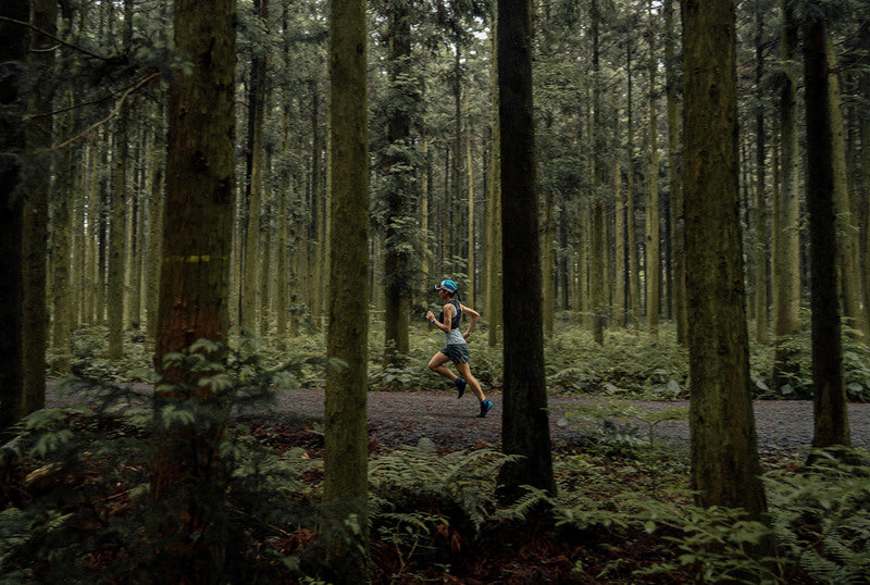
Lead image: © Philipp Reiter


Who’s having the most fun exercising? Here’s the answer – based on data!
Feeling is an excellent metric for recovery. If your feelings after exercise start to trend downwards, something is not right. You may be pushing too hard, not recovering well enough or might be getting sick. Consider taking a break or doing something different for a change.
But in addition to helping you track your recovery, feeling data reveals more. Here are six interesting findings about Suunto community, based on the data from Suunto app database.
1. Activity type does matter: The best feelings on average are recorded after dancing, downhill skiing, horseback riding, badminton and snowboarding.
2. Two activity types stand out as exceptionally poor: The feelings after running and trail running are clearly below other activity types.
3. Weather does not have a big impact on the feeling – unless it is a torrential downpour: The activity type, for example choosing cycling over running, has a much bigger impact.
4. Gender makes a difference: Women have more (or at least as much) fun as men in all other activity types except soccer.
5. Age does not matter: The age of the athlete did not have a correlation with the mood after exercise.
6. Country heavily impacts the mood: People exercising in Austria, China, Croatia, Poland and Serbia are generally feeling exceptionally well after a training session, while France, Italy, Japan, Spain and Sweden are in the opposite end of the list with much poorer feelings after working out.
In addition to fun facts, the data also reveals interesting trends: As an example, the feeling in cycling, swimming and walking rose to a new, higher level in March 2020 and has stayed on that higher level. Changes in other activity types since Covid pandemic started have not been as clear.
Happy adventures – and keep on tracking your activity feelings for your own wellbeing and our shared interest!
Lead image: Harald Wisthaler Bikewash image: Anthony Bonello


Get the perfect shots - how Suunto watches help photographers
All photographers have been there: you’re heading up into the mountains to capture that long sought after moody landscape, but arrive just as the light gets that touch too low or too bright. It can be so frustrating, right? Pro adventure photographer Maximilian Gierl knows the feeling well. He says that’s why it’s so exhilarating to finally capture the perfect shot. It takes patience, time, often disappointment, which makes it that much sweeter when he nails it. Take for example the shot below of him jumping on a trail in Chamonix with Mont Blanc in the background. He had it in mind for years, but the conditions never played ball when he visited. And then finally he got the sweet taste of success.“This is a shot when everything just aligned,” Maximilian says. “I love being in Chamonix in autumn - the clouds, lakes and forest are so special. When we got to Chamonix, I saw I could finally get this mood I had been searching for for years. I ran up 1400 m as quickly as I could to get it.”
Climbing 4000ers and mastering timing
From Germany and living in Switzerland, Maximilian has recently finished an alpinism challenge he began in 2015: climbing all 48 of the alpine nation’s 4000 m mountains while documenting the adventure. “It’s pretty good for someone who didn’t grow up with mountaineering,” he says. “I started mountaineering in 2015 and climbed most of them in the last two years.”For Maximilian, the best outdoor shots are moody with a mix of cloud and light. “I love to shoot landscape scenes you can’t shoot one day later again,” he says. “It’s a challenge and hard to plan. If it happens and you nail the shot, it’s super crazy.”With timing being everything, Maximilian uses his Suunto 9 Peak to manage his photography adventures.His watch helps him get to his shot locations on time for the best light conditions. Here are four ways his Suunto helps him nail epic shots.
Navigate in the dark
The last of Switzerland’s 4000 m giants Maximilian climbed was Lenzspitze (4294 m), which is famous for its imposing north flank - a 50-55-degree ice wall. Maximilian and his climbing partner followed a route on their Suunto watches to climb the face and reached the summit before sunrise.
“When going to shoot in new places, I plan the route in Komoot and transfer it to my Suunto,” Maximilian says.” This is especially helpful when I’m ascending in the morning when it’s still dark out. Then I use the navigation and it’s super helpful and easy and means I get there on time.”
Read more:
How to find routes that rock
How to create your own routes
Set sunrise and sunset alarms
Maximilian uses his watch to make sure he’s on location for the golden hour (the last hour before sunset and the first hour after sunrise) and the blue hour (one hour before sunrise and one hour after sunset), when the light is best for photography. His watch also shows him how long the blue hour, his favorite time for photography, will last.
Maximilian sets sunrise and sunset alarms to help with time management so he’s in the right location at just the right time. “Knowing the time of sunrise at my location helps me to get as much sleep as possible while still being on time at the planned spot,” he says. “I time the alarm 10-15 minutes before I need to go.”
The sunrise/sunset alarms in Suunto 9 watches are adaptive alarms based on your location. Instead of setting a fixed time, you can set the alarm for how much in advance you want to be alerted before the actual sunrise or sunset.
Read more: how to set sunrise and sunset alarms.
Get key info at a glance with Suunto’s Outdoor watch face
The Outdoor watch face for the Suunto 9 Peak, Baro, 9, 5 and 3 watches allows users to track conditions and daylight hours with just a quick glance. No need to press buttons or scroll – the essential info is presented on the main screen. Maximilian uses it to help him stay on time and to determine when is the best moment for a shoot.
“Just a quick look on my watch tells me all the important information like the current altitude, moon phase and time until sunrise or sunset”
The watch face features a sun gauge that displays the number of night and daylight hours before sunrise and sunset. Tap the screen once, and the watch face displays the number of hours until sunset or sunrise, plus the battery life remaining, or the moon phase, which is helpful because on a full moon night you know you’ll have extra light to stay out a little longer.
Read more about the Outdoor watch face here.
Following the moon phases
Maximilian uses the Outdoor watch face to track the moon phases on his watch so he knows when is a good night and time to shoot the night sky. “It tells me when the night sky will be at its darkest,” he says. “I can then plan when to shoot the Milky Way.”
Read more about tracking moon phases here.
All images: © Maximilian Gierl Photography


Read this and understand how to have mental toughness
It’s almost become a cliché: our biggest obstacle is usually ourselves. It’s not “out there”, but usually “in here”. Recognizing this marks an important transition in life. It’s often when we really start to fly as individuals.
In endurance sports our inner obstacles get magnified and compressed into a short period of time. Especially at the elite level, our head space has a massive impact on our game.
Suunto ambassador Anton Krupicka has had a long career as an elite endurance athlete. Through the years he’s had ample opportunity to explore what it takes to build mental toughness. It’s a slippery thing, he says. Something we must take hold of again and again.
Read on for Anton’s eloquent take on the secrets of mental toughness.
Waiting for the start at Unbound XL 2022. Photo by Sami Sauri
By Anton Krupicka
Unbound XL 2021
In 2021, when I first rode the Unbound XL–an approximately 350-mile (563 km) gravel race in the Flint Hills of Kansas–I came away from the weekend a bit, I don’t know, unimpressed, I guess. Underwhelmed, nonplussed. I hadn’t found the experience of riding my bike over the course of 28hr as emotionally affecting or significant as I had expected or hoped. Pedaling back into Emporia at the finish contained none of the end-of-race euphoria, relief, or satisfaction that I’ve come to associate with such ultra-endurance pursuits.
After letting the effort marinate for a few days, however, I realized the flatness of my experience was on me. For the first 250 miles (402 km) or so I had done a relatively good job of staying focused and engaged, riding to the best of my abilities. In the last 100 miles (161 km), though, I had let heat and drowsiness (the race starts at 3pm; riding through the night is mandatory) dominate my mindset; I basically soft pedaled the last 100 miles. At the finish, I already knew I had let myself down, and as a result, the whole event left me feeling unfulfilled. This didn’t sit well, and after some reflection, I was determined to return in 2022 with a more resolute attitude and give the event the opportunity to have an impact on me. There’s a certain kernel of truth to the cliche “nothing risked, nothing gained”. I hadn’t taken any chances, and I was, appropriately, not rewarded.
When the tough get going ... Photo by Sami Sauri
Motivation & Racing
Recently, I was asked by a friend, after such a long career in endurance racing—primarily as a mountain ultrarunner—why do I still line up for races like the Unbound XL? It’s a good question, and I’ve asked myself that often. Over the last 15 years, my motivations for racing have shifted significantly. Ten years ago, I think I was still firmly operating from a place of seeking external validation. I was racing for my ego, to beat people, to garner respect from the community and my peers as a top athlete.
After years of injury, and a certain amount of maturation, however, my perspective has changed. I’ve realized that races are rare opportunities for us to try our best. To try to be at our best. Now, my motivation is not external—I would say my physical prime has passed, and, in general, I’m simply more comfortable with who I am and my place in the world.Today, my motivation to race is more internal. I want to embrace the opportunity of working with other competitors to confront a significant challenge and be pushed and pulled to give it my best effort. To be proud of the way in which I conduct myself in the face of absurd difficulties. To fully experience life at an elevated level. The intensity of racing ratchets up the richness of life. So many emotions are crammed into a race—by time you get to the end, you feel as if you’ve lived a year’s worth of experiences, not just a day. Those are experiences that I never want to take for granted or stop seeking.
But, the nature of these events is such, that, to get there, you must, by definition, endure. This requires mental toughness. Last year’s Unbound XL taught me that a race is only as momentous an experience as the amount of effort that you put into it. Trying my best—regardless of finishing rank—is the essential ingredient to having an experience that will push me to grow, leave me satisfied and form a lasting memory.
Things don't always go to plan. Photo by Sami Sauri
Sagebrush & Summits: A Tour of Enduring
About a month after the Unbound XL last year, I embarked on a three-week, 2300-mile (3700 km) bike tour that involved running and climbing six of the highest, most remote peaks in the Rocky Mountains. It was arduous. Every single day I was forced to confront some kind of weakness about myself, some inadequacy to deal with the challenge. For the first week or so, it was really tough.
By the end, however, I felt that I could detect a subtle, but important, shift in my mindset. When things got hard, it did not feel as mentally difficult to bear as it had at the beginning of the trip. I had realized an important lesson–when things got tough, they were only unbearable if I let my mind turn negative and project to somewhere in the future. If only this hill/headwind/washboard/rain/heat/dust (etc. etc. etc.) would end! If only I were already at the top of the climb, or the next gas station, or the next town! I realized that living with that future-focused mindset is untenable. If I let my mind fall into such a pattern, the task at hand would always feel interminable.
The alternative, of course, is to strive for contentment in the moment. Once I could accept my inadequacies in the moment and make peace with the fact that all I could do was try my best, the angst would fall away. The present moment would become bearable, even enjoyable.
That lesson was the great gift of that long tour.
One thing at a time. Stay in the moment. Photo by Sami Sauri
Unbound XL 2022
In preparing for the Unbound XL this spring, I set out on a planned three-day tour of 150 miles a day in late March. My first night out went horribly. It was colder than I’d anticipated; my sleeping bag was too light. Out of desperation, I ended up sleeping in a Port-a-Pottie, desperate for any extra warmth. The next morning I woke up feeling depraved and haggard after hardly having slept at all. In defeat, I tucked my tail, and, after several cups of coffee, pedaled my bike the shortest distance possible back to my home (it was still over 100mi, but not at all what I had intended).
I had taken the lesson of the 2021 Sagebrush & Summits tour for granted. I thought I was permanently more mentally tough. This overnighter taught me that cultivating mental toughness—which really means mental equanimity in the face of hardship–was necessarily an on-going process. One never arrives at a state of mental toughness; it is a trait that must be constantly born anew.
I am satisfied to say that my experience at the Unbound XL a couple weeks ago was much different than last year. There were plenty of challenges. After only 70 miles I crashed hard, gashing my left knee, hip, elbow and hand. Despite all the raw wounds and torn up hand I was able to figure out a way to keep holding onto the handlebars for the next 280 miles. I fixed flats and didn’t give up when I no longer had anyone to ride with through the night. When the skies opened up with torrential rain in the last 50 miles, I just tried to smile and think about what a good story all the mud and water would make when we got to the finish line. I’m already looking forward to next year, but I know that having a satisfying race again won’t just happen. I’ll have to stay engaged and keep tending a mindset of contentment and equanimity. The trap of pining away for something different in the future is ever-present, but I’m now confident that with vigilance I can avoid it and have the adventure I’m looking for.
Lead image by: © Fred Marmsater

Celebrate Earth Day with us!
Starting this Earth Day, we have partnered with Hammerhead and Komoot to challenge you to #SeeTheAdventureAhead and share your natural wonder, however you explore.
Use the hashtag #SeeTheAdventureAhead when you share on Instagram, Facebook, and/or Komoot* before May 11th and we’ll plant a tree for every post, with the goal of planting 10,000 trees with Tree Nation.
Trees are key pillars of the world for both humans and the environment. They benefit us by purifying water, air and creating better social conditions. They benefit the environment by providing homes for various forms of life, cooling our climate and improving our soil.
To celebrate the wonders of our natural world, get out there and share your natural wonder. We'll plant trees through the VCS certified Eden project in Mozambique for each share!
*tag Suunto and Hammerhead when you share on Komoot
Find places to explore with Suunto heatmaps
Learn more about Tree Nation
Learn more about Suunto compatible cycling computer Hammerhead Karoo 2
Main image: @runningphotograph
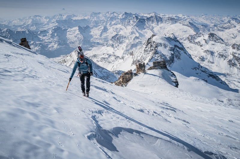

7 nations, 7 highest summits, 5 days
Watch how Philipp and Adrian's project unfolded!
Reaching the summit of Mont Blanc took everything Philipp and Adrian had in the tank. They began their climb of the highest mountain in the European Alps at 01:30 AM and, even though they had worked on acclimatization, they suffered on their way up and faced icy conditions. The ski down, involving crossing crevasses, took a brutal three hours.
“When we arrived back at the car 11 hours and 30 minutes after we had set out we were both super done,” Philipp says. “We both had headaches and had to travel by car for two and a half hours to Zermatt, sleep for two to three hours and get up at 2 AM to start over again to climb Dufourspitze.
“It was crazy, because for many mountaineers just doing one of the highest summits in the Alps is a big achievement, but we climbed seven in five days. For me, it’s still unbelievable because it happened so quickly that it hasn’t really sunk in yet.”
The 7 summits project
They started their adventure on March 26 at 06:00 AM, first climbing Italy’s Gran Paradiso. The goal was to climb the highest summit in each of the seven alpine nations - Italy, France, Switzerland, Liechtenstein, Germany, Austria and Slovenia - in seven days. However, weather forecasts predicted snow and harsh conditions on the last two peaks, leaving Philipp and Adrian no choice but to do all seven summits in five days, in this order:
March 26: Gran Paradiso (4061 m), Italy. March 27: Mont Blanc (4807 m), France.March 28: Dufourspitze (4634 m), Switzerland.March 29: Vorder Grauspitz (2599 m), Liechtenstein.March 29: Zugspitze (2962 m), Germany.March 30: Grossglockner (3798 m), Austria.March 30: Triglav (2864 m), Slovenia.
The project was a year in the making and originally involved a team of four, but a sickness and a death in one of the team’s families meant two of the four had to withdraw at the last minute, leaving Philipp and Adrian to scramble to keep the project from collapsing. To avoid piling pressure on themselves, they decided to keep their goal quiet until they reached the summit of Liechtenstein’s Vorderer Grauspitz.
Battling the conditions and sleep deprivation
They realized they needed to climb all seven summits in five days rather than seven after climbing Vorder Grauspitz and seeing a weather forecast predicting snow in the Alps. At that point, it was full steam ahead, with little time for rest and recovery. They only slept 14 hours over the five days, which included napping in the car - with damp clothes and cold bones - while driving from one mountain to the next.
“We had to be really focused because of the route navigation,” Philipp says. “We followed the tracks on our Suunto watches. This helped a lot because it gave us confidence and saved time.”
The stats
187 km17,001 m 111h40m
All images: © Philipp Reiter


