


Suunto Blog
Face to Face with Conrad Stoltz, #SuuntoAdventure Video Series Episode 5
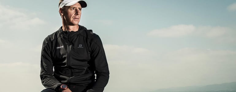
In the fifth episode of #SuuntoAdventure Video Series four time XTERRA world champion Conrad Stoltz talks about going fast, suffering and over 25 years of competing in triathlon.
Face to Face with Conrad Stoltz, #SuuntoAdventure Video Series Episode 5
Watch also the other episodes in the series:
Face to Face with Emelie Forsberg – #SuuntoAdventure Video Series, Episode 1
Face to Face with Greg Hill – #SuuntoAdventure Video Series, Episode 2
Face to Face with Kilian Jornet – #SuuntoAdventure Video Series, Episode 3
Face to Face with William Trubridge – #SuuntoAdventure Video Series, Episode 4
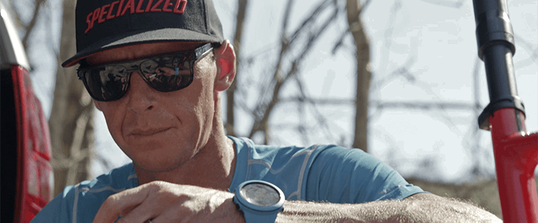

Conrad Stoltz: Caveman with a positive attitude
When it comes to experience, there are few athletes who can equal the triathlete Conrad Stoltz. The four-time XTERRA world champion has been competing since 1988, was at the Sydney Olympic games of 2000 and today, he's still feeling as strong as ever.
Stoltz says he’s just as fit as he was 20 years ago, and the proof is there as he regularly beats guys half his age. He puts it down to smart training and experience.
Says Stoltz, “My power on the bike is as good, if not better than ever.” He says this is partly due to the rigorous training program and partnership he has with his coach, Ian Rodger.
Stoltz also uses training data to optimize his training, sharing his stats with his trainer Rodger alongside a thorough report on how felt during and after the session. Rodger then analyses the data, and fine-tunes training for the following day.
It’s effective, he adds, but completely different to when he started out.
“Back then I wanted to train super hard every day, I wanted to race every weekend, and I wanted to win every race! It's simply impossible – I made every mistake in the book, and learned all the lessons first hand.”
And those early years as a pro athlete may have seen him race hard, but they were far from glamorous. According to Stoltz, “I slept on benches and in a Police station (willingly) before a race and I’ve won races on cheap, borrowed bikes.” It’s this hand-to-mouth lifestyle combined with a reputation for being hard on equipment that earned him the nickname “the Caveman”.
He competed in two Olympic games as a triathlete but switched to XTERRA early on. “Triathlon boils down to how much pain you can take — you just go as fast as possible. But with XTERRA there's a whole lot more to it. For a start the courses vary hugely, from volcanic beaches in Hawaii to the mountains of the Alps to the forests of Brazil. That adds a new strategy to it, from your suspension set-up to what tires you select. And along with the lactic acid you get a lot of adrenaline and that's what makes it fun.”
Nonetheless, Stoltz is also well-known as a humble and popular competitor. After winning his 50th XTERRA competition, he remained at the finish to high-five the last competitor to cross the line and share in his accomplishment of simply finishing the race.
While he maintains a pure love for the outdoors, Stoltz readily admits that breaking the tape at the finish line feels great. When asked how he stays competitive he says it’s his experience that gives him the edge but, in the end, it’s his love of sport and a positive attitude that keep him motivated.
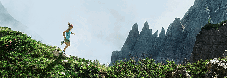

How to improve your trail running – with Emelie Forsberg
Skyrunning world champion Emelie Forsberg gives her tips on how to push your running comfort zone.
Keep running
To become a stronger runner in any kind of terrain you need to have continuity of training. You will always improve at something when your do it regularly for a long time with no breaks.
For this reason, try to enjoy your running. Even if a run is no longer than 15 to 20 minutes, it’s so much better than nothing if it makes you want to run again. Sometimes I do short runs because I know I will feel better after a few minutes, even if I’m tired when I start. I do it because I love having the continuity.
Continuity of training is key, says Emelie. © Salomon
Push your comfort zone
If you already love running and want to become stronger, push yourself every now and then outside of your comfort zone. Maybe one or two of your training runs can include some non-comfortable pace. That small effort will make you better.
Play with speed
To become a better uphill runner I’ve noticed uphill fartleks have worked for me. (Fartleks, a Swedish word that means ‘speed play’, is a form of interval training.) Run with speed for a few minutes, then slow down and then run again with speed and try this on different slopes for variation. Try to be fresh when you do this training!
Emelie won the Transvulcania ultra marathon on the Canary Islands. © Selu Vega-Transvulcania
Power the hills
To improve your uphill endurance, try to run or fast walk the whole slope or mountainside, even if it’s a long ascent.
Recovery is king
Recovery is important. If your recovery isn’t good enough, training gradually breaks you down. I try to rest as much as possible when my body tells me I need it. It’s better to be fresh and able to keep training than to break down or get injured and not to be able to train.
Remember to have fun and enjoy your runs! © zooom.at/Markus Berger
Eat well
Always eat and drink well for recovery. I love natural ingredients and avoid eating too much meat. I feel best when I eat a lot of vegetables and a big dessert!
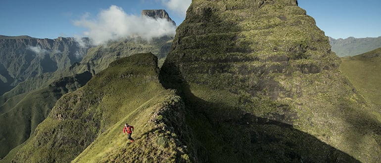

How to go the (ultra) distance – with Ryan Sandes
From mastering the art of recovery to learning to hike, these are the tips from champion ultra runner Ryan Sandes that will see you through an ultra. This is part one of a three part series. Click here for part two and here for part three.
1. Listen to your bodyWhen you're training for a 100 km race it’s important to have a training schedule, but you must be flexible with it. A lot of ultra runners get hell-bent on achieving their goals, causing them to lose sight of the bigger picture. You really have to listen to your body. If your body is not feeling up to it one week, then back off. If you’re feeling on top of the world, maybe you can do a bit more. Remember, the schedule is a guide only.
“Recovery is more important than running.” ©Craig Kolesky/Red Bull Content Pool
2. Stay mobileBefore I run, I often do 10 to 15 minutes of basic mobility exercises to ensure everything is firing when I start running. It’s important to build basic mobility exercises into your training, even if you only have time for two or three minutes before you start running. Side bridges, basic mountain climbers, bear crawls, A-marches, lunges and ABC drills are all helpful.
3. Better to be under than over trainedTraining for an ultra marathon isn’t just about how many kilometers you run each week. I know a lot of guys who came into the sport and for two years did high mileages and won races, but then burned out. If you're new to the sport and you're doing a high mileage, you're really risking injury. For me, I'd rather go to a 100 km race 20 per cent under trained than one per cent over trained.
©Craig Kolesky/Red Bull Content Pool
4. Have an off-seasonIt’s important to have an off-season. I don't mean taking three months off and doing absolutely nothing! It’s fine to take a month off and just hang out with your friends and have a party or two. But then spend the next two months doing strength work in a gym to prepare yourself for the season ahead. This helps prevent injuries.
5. Hike that long run When you're trying to build up for an ultra distance trail race, it's important to incorporate hiking into your long runs. It helps you get extra time on your feet. You might start with an hour or two of hiking and then run for two hours afterwards, or hike for an hour, run for an hour.
©Craig Kolesky/Red Bull Content Pool6. Keep a logKeep a logbook and write briefly after each run what you did and how you felt so you can look back and see what’s worked and what hasn’t. 7. Spend time on recoveryRecovery is more important than training! It's vital to make sure you're getting enough rest and sleep. If you're working full time then you need to be really careful, as it’s all a lot of stress on the body. Get regular massages, too. Our legs are like car wheels – you might have a Porsche, but if the wheel alignment is out, it's not going to drive well.Main image: ©Kelvin Trautman / Red Bull Content Pool
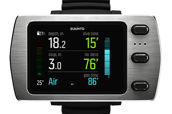

New features for the Suunto EON Steel now available
Software update brings gas time, CCR mode, real-time gas consumption and compass bearing lock.
Suunto EON Steel grows with you as your diving skills evolve, thanks to its customizability and durability. As communicated with its launch last fall, you can update the EON Steel software yourself. The update now coming out brings much sought after new features. Gas time
The new gas time reading allows you to estimate how long you can continue diving, taking into account your current tank pressure value and breathing rate.
Rebreather mode
Closed-circuit rebreather (CCR) mode makes Suunto EON Steel a great backup dive computer on rebreather dives. Combined with the Suunto Fused™ RGBM, the CCR features give you extra confidence on your rebreather dives.
Gas consumption
A first for dive computers, Suunto EON Steel calculates real-time gas consumption. As you improve your diving skills, you’ll see your comfort level reflected in the rate: the more relaxed you are, the less gas you consume.
Compass bearing lock
The new compass bearing lock helps you orientate yourself underwater and ensure you maintain your direction of travel. For example, you can set a bearing lock for the direction to the reef before leaving the boat.
You can download the free update to your EON Steel through the Suunto DM5 software.
Check out more details about the Suunto EON Steel software update 1.1.

Caveman’s dirty secret: manual labor
Seven time world triathlon champion Conrad Stoltz, aka Caveman, has a secret: in his free time he enjoys getting his hands dirty with some old fashioned manual labor.
Caveman Conrad Stoltz wouldn’t be where he is without a lot of hard work.
After all that blood, sweat and tears getting to the top as a triathlete, you might guess the four-time winner of the XTERRA World Championship favors lazy days in his downtime.
Nope. Not Caveman. Instead he likes getting his hands dirty with some hard graft.
Caveman built his own pool to cut down travel time. © Conrad Stoltz
This predilection first grew out of a problem: a few years back Conrad needed somewhere to swim when he was staying at his family’s remote farm in South Africa.
Rather than travelling a long distance by vehicle to the closest spot, he rolled up his sleeves and made his own swimming pool in the backyard. Over three summers he dug out a 25 m long trench, lined it with sandbags and plastic before hooking up a pipe and filling it with water from a nearby stream. No diggers, all by hand.
“For some reason I enjoy hard manual labor and then seeing a solid result at the end,” he says. “Whereas with a lot of the other work I do, with training and triathlon, I work really hard, but at the end of it you don't really have something concrete to show for it.”
Handmade. No diggers used. © Conrad Stoltz
After completing his pool, Conrad moved on to a new labor of love: he built a dirt pump track for the local kids in a poor community nearby his home in Stellenbosch.
A pump track is a small, looping trail with dirt mounds and is designed for bicycling without pedaling. Riders use a pumping motion to maintain their speed as they ride around and around.
Pump tracks are great for improving skills and fitness. © Conrad Stoltz
Conrad and friends were given land on the edge of town for the project. With the help of a digger and about five men, they had it built in a few short hours.
“Pump tracks are a fun way for kids to learn to love cycling,” Conrad says. “It’s a social gathering place and a breeding ground for budding mountain bike or BMX riders.
“Kids like being challenged, learning new stuff, being active without feeling like its serious training. When kids have fun on bikes they tend to stay off the streets and out of trouble, which is the main reason I built this track.
“I’m quite passionate about it and will do some coaching there too.”
Fancy bikes aren't necessary to have fun on a pump track, says Caveman. © Conrad Stoltz


