


Suunto Blog

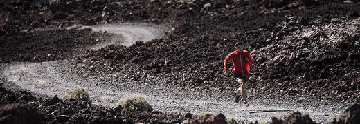
What’s the Ultra Trail world champ doing this year? More running
Let’s start simple, Gediminas – why’d you win?
Easy – I don’t take defeat well. I wasn’t happy with my second place finish in 2015 – I was so close to first, but I made a mistake in the Grand Raid Reunion. I wanted to come back and do better. I also got a little bit of a nudge from Red Bull – but not in the normal way. I went for a little workout with them, but in the end, they weren’t keen on taking me on as an athlete. Those two things gave me something to prove.
How long have you been running?
I started in 2005 after my mission in Iraq. I didn’t do my first Ultra until 2009 tho. It’s been a very moderate progression over the years, but losing so closely last year really inspired me to train better and smarter.
Gediminas Grinius was crowned the champion of Ultra Trail World Tour in 2016
Tell us about 2016:
I kicked off with a 3rd in Hong Kong, and quickly followed with a 2nd in Gran Canaria, a 2nd in Lavaredo, and a second in UTMB. There were ten races on the tour, but only Sange Sherpa ran 6 (and never finished in the top 10) and two other runners did five. Four races with a podium finish was good enough to lock up the title!
What was your training strategy?
Quality over quantity. I tried to run from 100 to 150 km a week, depending on the block of training and periodization. In general, I am trying to run 5–6 times a week, between 20–40 km a week, including HIIT, intervals, back to backs, stuff like that. There are difference skills I am trying to develop. I needed more speed in UTMB so I am adding in more speed work, for example. But as I approach a race, I do more long runs and back-to-backs.
What’s a back-to-back?
I go for a long run late in the evening, then have a short recovery time – basically going to bed on an empty stomach, then waking up and running again. Generally I’ll try to do between 25 to 30km both of those days, and have a negative split – faster on the second day.
Who do you hate to see next to you on the start line?
I like the competitors in the field, and I like the challenge. No runners which I hate.
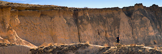
Gediminas training in Cappadocia, Turkey in December 2016.
Where do you like to line up?
I do well in the longer races. I think my strength is in my mind – up to 100km, your physical state is a big factor, after that, many things come in to play. Even in our ordinary life, we have a lot of stress factors. We can cope with them in our ordinary life, and when you do back-to-back runs, you give your mind understanding of how to deal with stress while running – this is how training of mind goes.
What’s the plan for 2017?
Honestly? I had a very intense last three years, and right now I feel a little exhausted. The plan for 2017 is to run a bunch of races I didn’t run before because of the point counting system – spend more time with family, and run the races. The first will be Tarawera Ultramarathon in New Zealand, Madeira Island Ultra Trail in Portugal, and then I want to do the Cappadocia Ultra Trail in Turkey.
And beyond?
I’ve got my eye on a FKT – running around Lake Tahoe in Northern California in 2018. Then in 2019, I’m going for a combined record time on the Ultra Trail Grand Slam.
Big goals. Any changes in your training plan?
Yeah. I think I’m getting a coach.
Images by Salomon Cappadocia Ultra-Trail
READ MORE
Four myths about ultra running that you need to know
How to transition from flat to off-road
How to run a sub-3h marathon

7 Terrain Tricks Greg Hill (literally) can’t live without
Watch Greg Hill’s "7 Terrain Tricks"
This sounds like a lot of thinking to do.
That’s OK – it takes a lot of time to go up. It’s all about developing a loop of thought patterns that you keep going over and over – where’s the next safe spot? What’s above me? What dangers am I exposed to, and where am I going if something happens? – that’s what keeps you safe.
And it’s not about making things tough – sometimes it’s about making them easy.
Yeah – especially the ‘fight the smallest guy at the bar’ trick. You want to go up the safest, easiest terrain, because often, it’s the least exposed to danger. If I’m touring in a new area, I’ll have looked at a map, found the smallest slopes, and used that information while I’m out there.
Greg, who taught YOU the tricks?
Most of these I picked up at the beginning of my skiing career – but mostly, I’ve learned from the mountains themselves. If you watch and listen, you can learn a lot – and that’s at the heart of what many of these tricks are about. Nothing can teach you something like a real-life example. Early on, a mentor taught me to ‘always ski from the top’. Not long after, I found myself on a tour, about to drop into a line, and realized, I wasn’t at the top. So I got back on the ridge, worked my way to the top. The third turn in I sent down a Class III slide that would have almost certainly killed me.
That’s not the only time you’ve seen these tricks work in real life.
Absolutely not. "Seeking the higher ground” – we were on Mt Manaslu in 2012. We camped on the highest ground we could find. That night, an avalanche caught 30 people sleeping in tents. Camps II and II got hit. 12 people died and 30 were caught in their sleeping bags. We were above the slide because we’d picked a spot with no risk from above – just 50m away from where the slide hit.
You want to reduce your time of exposure – but that doesn’t mean you need to rush.
Yes – movement between safe spots should be fast, but don’t make hasty decisions. Move quickly, think calmly. You don’t want to rush decisions.
Is it possible to reduce risk to zero?
Absolutely not. And for me, that’s part of the definition of adventure – it’s an activity that involves risk. That admittedly is part of what makes it exciting and interesting.
Stay tuned for more from Greg Hill in the next instalment of his video series – and ski safe!
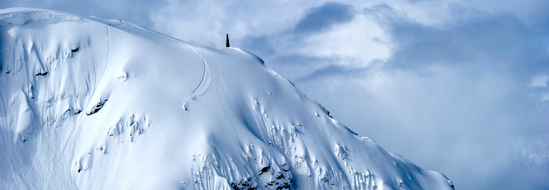
Main image: Bruno Long
READ ALSO
Greg Hill's mountain rules

Watch these divers explore the Abaco Blue Holes –?live!
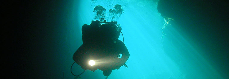
Even if you’re just a casual diver, you’ve heard of Dean’s Blue Hole in the Bahamas. The deepest saltwater blue hole in the world, at over 200m, it’s a mecca for underwater adventures of any sort – from scuba divers to free divers.
But what many don’t realize is the island nation is home to not only this natural wonder, but many more as well. The caves are referred to as the Abaco Blue Holes, it’s one of the most diverse and vast cave diving areas in the world – with many caves still unmapped.
That’s precisely why Suunto diver Jill Heinerth will join an elite crew of divers in the Bahamas for a massive survey and documentation push on the Abaco Blue Holes.
"I will be joining an elite crew of some of the finest cave diving explorers on the planet, lead by Dr. Kenny Broad, we will be joining Brian Kakuk of Bahamas Underground, and the Friends of the Environment in Abaco,” says Jill.
The area is rich in dive history – her partners on the project have been exploring these caves for over two decades. You can make legendary dives through areas like Fangorn’s Forest in Dan’s Cave, or see artifacts such as 3,000-year-old crocodile skeletons in Sawmill Sink. Of course, diving here is with no small risk – as always with cave diving, the right equipment and a wealth of experience from at least someone on your team are absolute necessities.
What’s the occasion for the study? "After over a decade of hard work, these blue holes have recently become protected within a newly designated national preserve,” Jill tells us. What’s even more interesting is that while this project is an underground operation, it isn’t undercover. They’ll be broadcasting almost live. “The team also has an aggressive outreach initiative that will include satellite transmissions to classrooms from the field and advanced 3D imaging efforts that will help to develop interactive resources that will help topside visitors get a sense of the beauty that resides beneath their feet.”
Things they’ll see in the caves include stalactites and stalagmites formed by deposited calcium. They can be rich environments for marine life – Bahamas-based diver Brian Kakuk calls them ‘overstocked aquariums’ – and they hold unknown potential for research – and it’s big win for research. These caves have been important laboratories for climate change science and biological studies and their new added protection will undoubtedly offer many more opportunities for science.
Follow along to see the Abaco Blue Holes project in action!
Watch Jill Heinerth’s Expedition files on Youtube.
Get ready for hangouts by satellite: Virtual Field Trips to the Bahamas!
This week a new BGAN unit (textbook sized device that allows video Google Hangouts from pretty much anywhere on the planet) will head by boat to Abaco in the Bahamas on a National Geographic Expedition with Kenny Broad and Jill Heinerth.
The next hangout, an EBTSOYP Hangout, will be on December 8th @ 11am EST. Lots of camera spots available and you can check out a background hangout with Kenny and Jill here. >>Watch a replay of the Virtual Field Trip here<<
Read more about the project at intotheplanet.com

This is what the perfect dive trip looks like
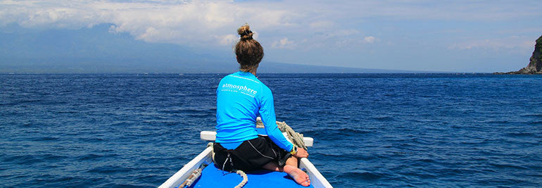
Last month, we sent Suunto #DiveWithMe winners Anna Starup and Theresa Thorp to the Philippines for a little dive adventure in paradise at Atmosphere Dive Resort – suffice it to say the girls enjoyed themselves. Now that they are answering e-mails again (because let’s be honest, we wouldn’t be answering e-mails on a dive vacation either) we pinged them with a few questions about the trip – and of course, got some pics.
Anna, this was a learning experience for you.
Anna: Yeah – I did my final certification in the Philippines after preparing at home in Denmark using online courses. Diving just caught me right away. In retrospect I’ve thought about why I didn’t take my open water earlier. Diving is definitely going to take me (and Theresa) to places in the world I’d never considered before.
Best single dive of the trip?
Anna & Theresa: That’s actually quite a hard question! The dive sites differed a lot and each had amazing aspects about them. Perhaps a dive at Apo Island where we saw a dozen turtles that played around with us. Or a dive where a blue-ringed octopus saw its reflection in Anna’s dive instructor’s camera and attacked it! At the same dive we saw 4 species of Octopus’ and a lot of cool frogfishes.
Of course, you didn’t spend every moment on the boat…
Anna & Theresa: Atmosphere quite is a little piece of paradise. Rooms, dining area, dive shop, beach – just amazing. We’ll have to mention the food here as well. Besides diving, eating was definitely a highlight every day! The people at Atmosphere were a huge part of the amazing experience we had. Everyone seemed like a little family, joking around, stopping for a chat, taking interest in each other’s (and our) lives.
You made such good friends, you even got a nickname…
Anna & Theresa: Someone from the dive crew, jealous of our cool Suunto D4i, nicknamed us “The Suunto Girls”, which kind of stuck to us for the whole trip. Not the worst nickname, right? We also have to send a special “thanks” to Ulrika, Marco and Daniel from the Atmosphere family, who were the main reasons why this trip became such an irreplaceable and spectacular adventure. We’re still feeling completely and utterly high on life, thank you!
And you even got into the jungle!
Anna & Theresa: On our way to the resort we met up with Theresa's brother and friend who is currently backpacking their way around Asia. We woke up at 5AM for a short jungle hike which led us to the most stunningly beautiful, lagoon called Kawasan Falls. Being there early meant having the waterfall all to ourselves for hours! A ton of fun swimming, cliff jumping and playing around in the lagoon before we continued on our journey to Atmosphere Resort. We also got to explore the Chocolate Hills, joined a dinner cruise at Loboc River, saw the Tarsier Sanctuary at Bohol Island, and visited Osmena Peak, the highest peak at Cebu Island. All spectacular sights and irreplaceable small adventures.
Do you feel more confident underwater?
Theresa: Getting to share the incredible underwater world with Anna for the first time was magical! We had so much fun during her Open Water Course, and later during our fun dives.
Anna: I had studied quite a lot of theory, but all of it made sense when I got to try it in the water. I wasn’t sure how much I was going to remember if a situation occurred where I actually needed it, but during my very first dive for instance, my mouthpiece came off. Without knowing exactly what was going on, I just grabbed my reserve. So I think some of the exercises “internalizes” pretty fast.
Can you name some of your favorite spots for future visitors?
Anna & Theresa: The "turtle" divesite at Apo Island was called Rockpoint West. The divesite where we met the blue-ringed octopus was called Secret Garden although we called it Octopus' garden, as we saw a lot of octopus there. The whaleshark spot was called Oslob.
Are the Philippines as a must-go dive destination? Theresa: Absolutely – especially if you're into muck and micro diving. It caught me right away, and I'm still in awe that critters, like the one we met, actually exist in real life! I was especially fascinated by the many different species of frogfish, nudibranch and mantis shrimp.
Would you go back?
Theresa: Definitely! The amazing dive sites and spectacular nature are sure to drag us back, and besides, we need to reunite with the amazing crew at Atmosphere Resort.
What other spots in the world are next on your must-dive list?
Theresa: Since this was my first time diving in Asia, I'll have to get back to explore some more! Right now places like Komodo, the Gili islands and the Maldives is on the top of my must-dive list. Galapagos has also been on the top of my list for quite some time now.

How to run a sub-3h marathon
Helsinki, Finland, based running coach Aki Nummela is no stranger to transforming weekend warriors to competitive runners. His company, Runner’s High, coaches hundreds of runners through clinics and private coaching every year.
“There are no quick wins in marathon running,” he says. “Many marathon runners only focus on mileage and actually train to be slow. And there’s no point in doing so. It is impossible to run a sub-3h marathon if you can’t keep up that pace for 10 kilometers. Versatility in training is very important for long distance runners."
Running a marathon in under three hours is a serious challenge: Some talented runners can make it with very little training. For many it is simply impossible. Suunto's training database actually reveals that 10% of 30–40-year-old men run a marathon in 3 hours, and the top 10% of women clock in about 15 minutes slower.
For reference, let’s take a look at what our numbers tell us. The top 10% of men 30–34 run a marathon in 3.00.08 and top 10% of men 35–39 run in 3.00.31. The top 10% of women 30–34 run a marathon in 3.16.34 and top 10% of women 35–39 run in 3.13.59. The times are based on over 25,000 marathons.
“A sub-3h marathon is a serious goal,” Nummela continues. “Most who set out to reach it are already established runners who know their level and have experience in running marathons. Random goals simply don’t work. You need to start with your current form and progress step by step within your own abilities. There are no short cuts.”
KNOW WHERE YOU’RE AT
Reaching the goal depends a lot on the past, too. If you already have trained well your progress will be slower than for someone who hasn’t put too much effort in structured training yet.
“When the base is strong, there’s no need to cover maximum amount of miles. Trying to add more miles in our busy lives may just wear us down before the week’s key workouts,” Nummela says.
“For some of my athletes it has come as a surprise that there may be less weekly training hours in their plan than before. But cutting mileage by half does not automatically drop performance.”
TEST YOUR SPEED
“Many marathoners are afraid of running fast” Nummela says. “But you need to start fast to have a fast time. Picking up the pace during the run is very difficult.”
A sub-3 hour marathon equals a pace of 4min17sec per kilometer, “but don’t get stuck running with the 4'20 pace in training,“ Nummela reminds you. “You need to build the speed capacity and once you’ve got this, you can add more marathon specific workouts in your plan. “
Nummela says that taking a good look at the times 3-hour marathoners have ran in shorter distances will give you a good idea where you are at. “If you can run 10 kilometers in 37 minutes, the pace needed to run a marathon in under three hours will feel easy.”
FIGURE OUT YOUR BEST WORKOUT
A classic workout for marathon is a progressively paced 30–35 km long run. “This workout should be finished off with your actual marathon pace,” Nummela says. “But keep in mind that this is a hard one, like a race, and proper time for recovery is needed.”
He also suggests running half marathons. They are not only great workouts – they’ll also teach you a thing or two about racing.
In addition to long runs, Nummela always makes his athletes run shorter intervals, too. Something like 6 times 1000 meters (at 5.000–10.000m race pace) and 4 times 2–3 kilometers (at 10.000m–half marathon pace) are great practice for fast, efficient marathon running.
At the end, he always stresses changing it up: “Versatility is the key. After a long hard one I suggest running something different, like the 6x1km mentioned earlier, so that the stimulus is different every time. Otherwise your progress will slow down.”
TRUST YOUR INSTINCTS
Coach Nummela thinks that both pace and heart rate are valuable info to runners. In training HR will prevent you from going too hard.
“But feeling is also very important. One should not look at the data on the sport watch too much either. You will need to learn to listen to your body and its signals, too.
ADJUST ON THE FLY
Goals are important – but you should be prepared to adjust your goals if needed.
“Running a sub-3h marathon depends a lot on the day’s form and conditions as well. If for example the race day is extremely hot, it is only wise to back off a bit. It may be smarter to run a 3:10 marathon than to end up on a drip. Be agile in your running and your thinking and you will eventually reach your goal.”
“And once you have trained right, and are in great form, all you have to do is go out and do it. Then reaching your goal is easy.”

What rules does Greg Hill live by? Watch and see
Watch Greg’s video below to learn the rules and find out why they are important for you too – then scroll down to our interview with Greg to learn more about the life experiences that shaped them.
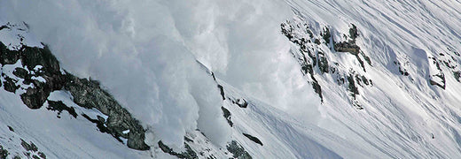
Greg, let’s start with the obvious: tell use about that avalanche!
May 15th 2014. Deep in the heart of Pakistan, at 5500m, as far from rescue as possible. I only broke my leg, but was very lucky to have lived at all. It was only 30cm high, but it was a few hundred meters across, but the entire feature that I was skiing slid for about 700m vertically.
What did you do wrong?
There was simply nowhere to go – and that was my technical mistake. What I did wrong was skiing a feature with no escape routes or safe spots. I skied like I was able to outrun an avalanche. A small ski cut would have triggered the thing and I would have been on top. But the bigger rule I broke was rule number one – not being afraid enough. I also broke rule number two – the partners I had there weren’t my normal partners. My normal partners would have questioned me more. They didn’t question me enough. Did they learn something from this? I bet they did.
Why did you need to be in that avalanche?
The funny thing is, I had lasted so many years without any issues – I needed that slide to keep my ego in check. There weren’t red flags popping up. We had waited a bunch of days for the snow to settle. The mountains were dormant. But I still broke the rules.
What’s your biggest tip to help you follow the rules?
Keep asking yourself questions. As you’re hiking up. Am i being afraid? Am I well-trained? Do I have the knowledge to back my decisions? Are my partners adding more? Always remember – you don’t know you're making poor decisions, until you experience a consequence.
What can we learn from you next?
This is a lead-in to my terrain tricks video – we’ll discuss concrete, tangible terrain decisions that will help you find ways to wander around the mountains and stay safe.
Stay tuned for more mountain advice from Greg Hill in December!
READ MORE
PREPARE FOR SNOW


