


Suunto Blog

Vertical Blue 2021 takes off
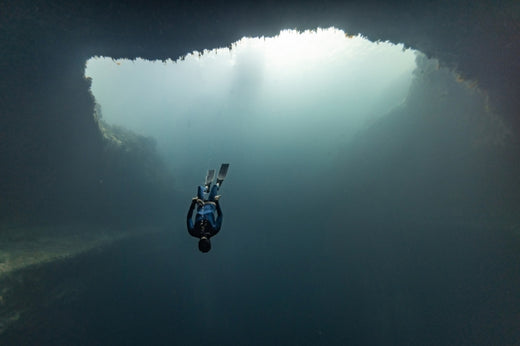
William Trubridge prepares for a depth dive.
It’s the first international freediving competition since the start of the COVID-19 pandemic so a lot of excited freedivers are arriving at Dean’s Blue Hole pumped to dive deep at Vertical Blue 2021. Running between 13 to 23 July, it’s likely to be the most celebratory edition in the event’s 11 year history.
The first Vertical Blue since 2018, organiser and Suunto ambassador William Trubridge has been working around the clock to make it happen. The ongoing travel and health restrictions due to the pandemic have increased his work load 100 fold. But knowing how much it means to the freediving community makes it all worthwhile.
“In these last 18 months a lot of people have been trapped and locked down, not able to travel or go to the sea, but everyone has been continuing to train and they are all amped to get back into the water,” William says. “It's the first big freediving event since COVID hit so we will get a chance to see where all the top athletes are with their training, and what they have been able to improve on, or whether they are behind now because of a lack of depth training. First indications are that everyone has been training really hard and there are going to be some epic performances.”
Follow the action at Vertical Blue via YouTube live!
All the top athletes in depth freediving, in all three disciplines, are attending this edition. “All the current record holders will be in attendance and most of the people who are within reach of world records,” William says. “At the last Vertical Blue in 2018, there were some days when the average depth amongst men and women across all disciplines, including no fins, was deeper than 80 m. This year I think it could be even deeper. In training at the moment the dive line is rarely less than 100 m. We're going to see some mind blowing performances.”
Check out our visual guide to freediving
William and his arch freediving rival Alexey Molchanov will be competing – a now longstanding tradition – for the top spot in Constant Weight without Fins (CNF). The stress of organizing the event isn’t giving William the dedicated training and recovery time he needs to be at his very best. Moreover, he isn’t sure he’ll be anywhere near his best. Depth freediving is a sport where being in a relaxed state is essential for success.
“My training was going very well up until about a month ago,” William says. “I was making steady progress towards attempting a world record in Free Immersion. I'd gotten within a couple of meters of achieving it. I was doing beautiful, comfortable, relaxed dives to that depth. That's when stuff started to go downhill with the organisation work and the stress ramped up.
“Hopefully if I can get everything resolved, then take a few days rest, and then build my training back up again, maybe by the end of the event I might be able to do some kind of a dive,” William continues. “I doubt it will be a world record dive. But never say never, fingers crossed, let’s see what happens.”
All images: © Daan Verhoeven

Turning ideas into action
Tenji (middle), Kilian Jornet and David Göttler met while training in the Khumbu Icefall. © Tenji Sherpa
Suunto athlete Tenji Sherpa recently returned home to Lukla in Nepal after a difficult start to the climbing season at Everest Basecamp.The COVID-19 Indian variant was running rampant there. “Teams were stuck to their own sections at camp, different from past years where I could interact with friends working with other companies,” Tenji says. “It’s certainly a devastating situation that I hope soon begins to settle so autumn climbing can go ahead safely.”
Unfinished business
It’s not only more guiding that Tenji, 29, is looking forward to; he has his sights set on some ambitious personal climbs. Tenji is part of a growing number of Nepalese sherpas who are breaking out of the mould of traditional Sherpa work and showing the world they can climb just as well, if not better, than many of their Western counterparts.
At the top of the list of goals, Tenji has unfinished business on Lhotse (8516 m), the fourth highest peak in the world. In May, 2018, in the memory of his friend and inspiration the late Ueli Steck, Tenji attempted to complete the same daring traverse trip the “Swiss Machine” met his tragic demise on in 2017. “Inspired by his strength and support, I sought to climb Everest without supplemental oxygen and traverse to the summit of Lhotse,” Tenji says. “Unfortunately, the weather became too risky to finish Lhotse.”
This photo was taken while filming the Everest VR movie. © Jon Griffith
Humble beginnings
Tenji was born and raised in a small village called Gudel in Solokhumbu district of Nepal. Life was simple, he had a three hour commute to school each day, at a time when sandals were considered a luxury and running shoes were unheard of. As a boy he watched as his brothers and other villagers set off to the mountains to work as porters and guides.
Village elders mentored Tenji to do the same and by 2007 he was working as a porter to pay to go to college in Kathmandu. “Moving to Kathmandu was a huge change from life in the shadows of Everest,” Tenji says. “I knew I belonged back in the mountains. As such, I started formal mountain training in 2012 while continuing to work as a porter in the high season.”
Tenji gained his International Mountain Guide Qualification in early 2019.
Tenji with the late Ueli Steck on Jungfrau in Switzerland in 2015. © Tenji Sherpa
Meeting the Swiss Machine
His work as a porter is how, in 2012, Tenji crossed paths with Ueli Steck, who had made a name for himself for his lightning fast solo ascents of some of the world’s most challenging mountains, culminating in his legendary solo climb of Annapurna’s (8091 m) south face. On the night of the climb, Tenji had a dream of Ueli standing at the summit. The dream turned out right.
“From our initial meeting at Everest Basecamp, Ueli and I had a connection that sparked a great combination for climbing together,” Tenji says. “Learning from him when we climbed Everest together in 2012 was inspiring and confidence building, leading to our ascent of the renowned north face of Cholatse (6501 m). Teaming with Ueli on that technical ascent, I became the first and still the only Nepali to climb the mountain.”
Tenji says Ueli became something of an informal teacher to him. He respected Tenji’s ability at altitude, his work ethic and drive to challenge himself. And Tenji was inspired by the Swiss Machine’s alpine climbing style – fast, light, and without oxygen. “Ueli taught me that if I have an idea, it’s up to me to put it into action.”
In 2012, Tenji summited Everest without supplemental oxygen.
Tenji climbing Manaslu (8163 m) in winter 2020. © Tenji Sherpa
Guiding at the top
Now doing his own private guiding and working with a Swiss company, Tenji has summited Everest seven times and Manaslu (8163 m), and many 7000 m Himalayan giants. He’s pumped to take on new personal climbing projects, but has to sit tight until the pandemic is under control. The technicality of Cholatse’s north face continues to hold special interest for him.
When the pandemic first exploded Tenji was travelling abroad to meet climbers considering coming to Nepal. He got stuck in the U.K for five months before finding a way back to Lukla. He says the pandemic hasn’t been kind to Nepal’s guiding industry.
“Essentially more than a year out of guiding made for some challenging times,” Tenji says. “But despite the pandemic, the spring season this year has brought even more international climbers than any other year given that so many lost their climbs last year and that the Tibetan side is closed to foreign climbers.”
After years of climbing at the roof of the world, Tenji is perhaps better equipped than many to handle the unpredictability of living through the first global pandemic in more than a century. After all, what has alpinism taught him about life? “That it can change very quickly.”
Lead images:
© Tenji Sherpa
© Jon Griffith

Follow the adversity of Red Bull X-Alps live
Paul climbs Titlis in Switzerland during Red Bull X-Alps 2019. © Harald Tauderer / Red Bull Content Pool
Paul Guschlbauer could kick himself. A few months back, he was skiing on his local mountain when bad weather hit and he found himself in a whiteout. “In the middle of it I suddenly skied over a little cliff,” he says. “I didn’t realise what happened. I fell down the five to seven metre-high cliff and hit ice and my foot broke.”
That was three months ago, and has meant Paul lost two months of crucial training time in the build up to his seventh straight time competing in the world’s premiere hiking and alpine paragliding race. He has placed third in the last three editions, but this time can’t be sure how he will perform. “I feel I have good equipment, a good crew, I have a lot of experience with this race, but what I cannot know right now is how my foot will react, say, for example, after three days of walking 50 km,” he says. “I’ve had no time or chance to test it.”
Mont Blanc looms large
Red Bull X-Alps starts in Salzburg, crosses the Alps by foot or paraglider, and has, until this edition of the race, ended on the Mediterranean Sea in Monaco. But the race organizers – after looking for ways to make the 10th edition of the race tougher – have implemented what Paul says is the biggest change in race history; instead of making their way from alpine peaks to the Mediterranean Sea, the 33 competitors will complete a loop, starting in Salzburg, to Mont Blanc, which they must circumnavigate anti clockwise, before returning east to ultimately finish on the waters of Zell am See, Austria.
“At Red Bull X-Alps you can never say one stage or another will be the most challenging,” Paul says. “It all depends on the weather. Of course looking at it now, and assuming great weather, the Mont Blanc circumnavigation, to turn around and go back to the goal, is definitely the most difficult alpine and mountaineering wise. That will be a challenging part. I hope I can get there.”
If the athletes hit bad weather at Mont Blanc, and it’s not flyable, it’s going to be a huge challenge. Follow the journey and the adversity live here!
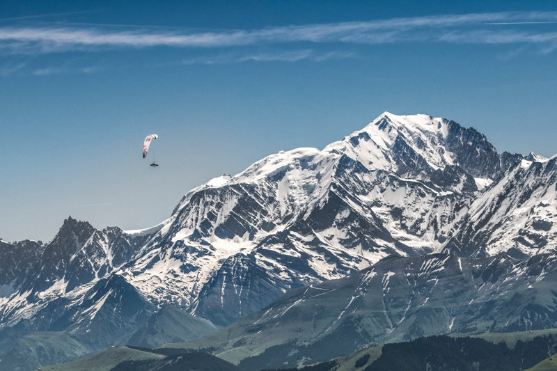
Paul soaring next to Mont Blanc in 2019. © zooom productions / Red Bull Content Pool
Suunto has their backs
Suunto is a race sponsor and the athletes will be using Suunto 9 Baro Titanium Red Bull X-Alps Limited Edition watches to guide their journey across the Alps and back. With a battery life of up to 170 hours, the sports watch tested to the extreme is designed exactly for this kind of epic adventure.
“The most important feature, besides telling me the time and the sunrise and sunset times, which is really important, is definitely navigation in combination with the Suunto app,” Paul says. “It’s super easy to get all the tracks on the watch and then navigate with it. That’s the most time saving point overall.”
We are only producing 1238 of the Suunto 9 Baro Titanium Red Bull X-Alps Limited Edition watches. One for every kilometer of the race. Get yours here!
New hike and fly watch feature
A new SuuntoPlus feature designed for paragliders will also support Paul and the rest of the athletes on their journey. The Red Bull X-Alps SuuntoPlus feature is a handy tool to keep track of vertical speed, similar to what a paragliding variometer provides. It helps the hike and fly community to see, feel and hear how fast they are climbing.
“The new watch feature is pretty cool,” Paul says. “It’s like a back up that you always have with you for if you didn't bring your variometer, or any other flying device. You can't use it instead of a real flying device, but on a hike and fly, if you forgot your equipment, it's great to have it.”
Follow the race live!
This 10th edition of the race is likely to be the most action-filled yet. Millions of people across the world tune in to watch the progress of their favorite athletes live on the state-of-the-art Red Bull X-Alps live tracking tool. It shows you where the athletes are on the map, and keeps you up to speed with breaking news from the field.
Find out about the athletes here, choose your horse, buy some popcorn so come race day on June 20 you’re ready to settle in and follow the action!
Lead images:
© zooom productions / Red Bull Content Pool
©wisthaler.com

Peak experiences are here and now
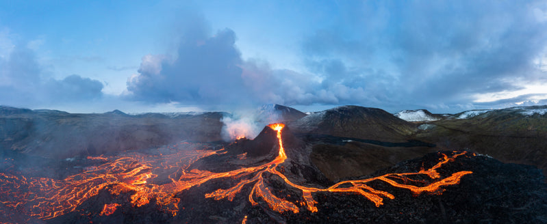
American photographer and artist Chris Burkard travels the world documenting amazing people, places and events. Recently he was visiting Iceland, a country he adores, to go on a bikepacking adventure. But life had other plans. A volcano erupted, and Chris knew it was a once in a lifetime opportunity to capture this incredible force of nature. It didn’t disappoint.
Press play to watch the power of nature!
What he witnessed blew his mind and got him reflecting on peak experiences, those almost altered states of consciousness characterised by euphoria and wonder. “I was just so honored to experience it,” he says.
We caught up with Chris and asked him about the experience and what he’s learned about peak experiences through his years of travelling the world and witnessing incredible things.
Do you often travel to Iceland?
I do! In fact I have been there 43 times. In some ways it's an obsession and I think what draws me there the most is the landscape as it’s so visceral and ever changing. But honestly, it's the people that keep me coming back and that keep me engaged and interested.
How did you feel standing so close to a live volcano?
Oddly enough I truly felt at home. At peace.. Like it's something I have been doing for thousands of years. In many ways it felt incredibly calming.
You mention peak experiences in your Instagram post – I imagine your work has brought you many – do these happen by chance or are there things, in your experience, we can do to invite them to occur?
I think that a “peak” experience is the byproduct of the time you put in. You realize at a certain point that to truly experience the height of something you need to slow down, be patient and really recognize when a moment is special. Sometimes a peak moment won't slap you in the face or excite you right away. You realize it later. It sort of dawns on you. I like to give myself the time and patience to recognize these moments. Rarely, when I do recognize them in “real time” it can feel really special.
What does a peak experience feel like to you?
It's a moment when your mind and heart and body are all in sync, it’s the certainty of knowing that there is no other place on Earth that I should be right now.
Do your peak experiences only occur in epic situations like your visit to the volcano, or, say, while surfing a perfect wave, or can they also occur in everyday life?
Everyday life. With my kids, at my property. On my bike commute. It's just the knowledge that a moment is special, will rarely be repeated, and you sort of get a glimpse of the future. And realize I need to cherish this.
You talk about the importance of giving yourself the space to experience before shooting – how do you personally approach this?
Honestly in some ways it kind of sounds like voodoo, but I truly feel like the way to really experience a place is to make an offering. An offering of time and interest and engagement. Not hiding from its many moods and feelings. Its storms and high winds. That is how you find a connection. You have to go through those things to really feel a place. I firmly believe that if you invest that time into a place and put in that effort, you are rewarded.
All images: © Chris Burkard
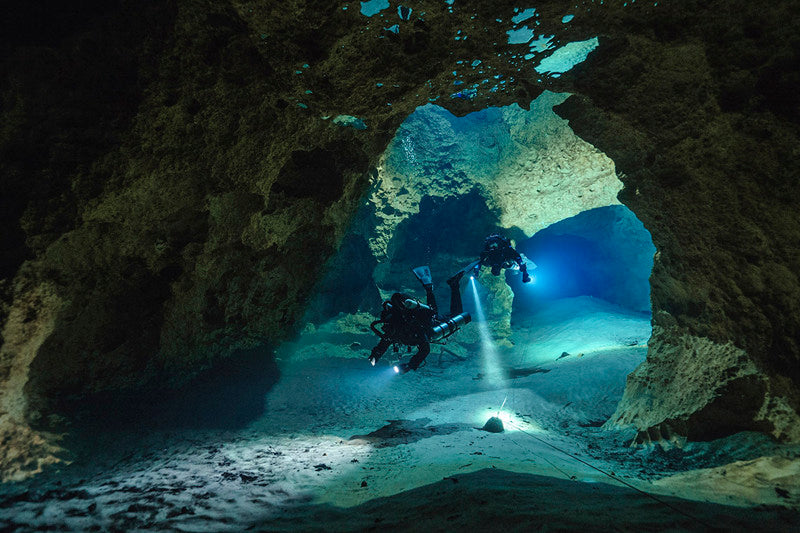

The canary in the coal mine
Suunto ambassador, pioneering underwater explorer and film maker, Jill Heinerth has dived in icebergs, explored deep underwater caves, and more recently documented the impacts of climate change in the Arctic Circle.
Capturing our changing planet and educating the public about the growing threat of climate change is what is increasingly moving her to dive and explore our blue planet. On World Ocean Day 2021, Jill shares insights from her 20 year career.
Press play to watch her incredible journey!
Where are you now and how has the pandemic treated you?
I live in a 200-year-old mill in a small town near Ottawa, Canada. It has actually been a bit of a gift to be home with my husband for a prolonged stretch, but I am certainly eager to get back to some of my travels. This has been a good time for rest, learning, and incubating new ideas.What’s been inspiring you lately?
I wrote the foreword for a new book by Frauke Bagusche. The book is called: The Blue Wonder: Why the Sea Glows, Fish Sing, and Other Astonishing Insights from the Ocean. I found it fascinating and quite inspirational.
What are you working on at the moment?
I'm exploring Canada's longest underwater cave system and documenting some of the endangered species I have found there. I am also actively involved in a documentary and educational initiative about the Great Lakes Watershed. With many of my projects on hold from COVID, it has been great to be involved in important projects close to home.It’s mind blowing how many incredible expeditions you’ve been on – how have they changed you?
Absolutely! As I get older, I feel more urgency to work on projects that really matter and that will leave a lasting educational legacy. I am drawn to work that communicates about water literacy and climate change. I think that motivational stories from the natural world and exploration can connect people to critical global issues.Is the underwater exploration and expedition scene attracting more women now?It is not happening quickly enough for my liking, but I am seeing more women involved in exploration. I think there are a lot of women that face serious roadblocks; difficulty getting career positions and opportunities.
You say you’re the canary in the coal mine – what are you seeing right now in terms of alarm bells?
Oh gosh, where should I begin? I'm 56 years old and I am truly shocked by the magnitude of change that I have seen in the natural world in my lifetime. The coral reefs I dived on 30+ years ago are dead and devoid of fish. The sea ice in the north sets up later and thaws earlier each year. The lakes that I learned to dive in have been grossly affected by invasive species. We are living in a rapidly transforming world. It frightens me, but I do not give up hope.What does humanity need to do to avoid crossing the tipping point?
I hope we have not already crossed the threshold, but I would say that we all need to stay optimistic. We might not have the big answers to the world's most pressing issues, but we all know small actions and changes that we can make in our lives that help move humanity in a positive direction. We need to urgently address the warming planet and water quality issues. They are all connected. Our actions against COVID-19 are a good example. We are delivering a vaccine that might have previously taken a decade to develop and test. We have the brain trust and the explorers that can solve big problems when we all work together.How has the development of Suunto dive tech aided your journeys?
I've been diving Suunto products for my entire career. They have always been innovative, well-built, and reliable. When somebody opens a box with a brand new Suunto product, they likely feel as I do... that this tool is going to accompany me on some of life's greatest adventures! One of the Suunto computers I used for record-breaking dives in 1998 is now on the wrist of a young whale researcher in Patagonia. I've passed on my older devices to others that are still using them today. That is quite an endorsement!Do you have any dream explorations you’d like to do?
I have not yet visited the Galapagos or Cocos Islands. I sure hope to make that possible one day. In the interim, I will have lots to keep me busy!
All images and video by Janne Suhonen, Divers of the dark

Help end plastic waste with your passion for running
Passionate runners don’t need an excuse to lace up and head out the door, but having the added motivation of cleaning up our oceans provides a welcome boost! More than five million runners across the world got that by joining Run for the Oceans 2021 and clocking up more than 56 million kilometers to help end plastic waste.
The campaign, which ran between May 28 and June 8, is a joint initiative of adidas and its partner Parley, which is an innovative space for thought leaders to come together to save our oceans. Parley’s Global Clean Up Network is dedicated to removing plastic waste from beaches, islands and coastal communities. With every kilometer participants ran, adidas supported the clean up of the equivalent of 10 plastic bottles. After the huge turnout, adidas is now committed to cleaning up 250 tons of plastic waste to prevent it entering our oceans. What a success!
Kimi Schreiber hit the trails between May 28 and June 8 to stack up kilometers.
It also raises awareness
German trail runner, blogger and Suunto athlete Kimi Schreiber participated in the global event and was excited to run a high volume of kilometers to help remove as much plastic waste from the environment as she can. “Sport can change lives and now it’s giving people around the world the chance to get actively involved in helping nature and preserving it,” Kimi says. “I think the most important argument for participating is the issue of attention. With such a large and global event, you can create awareness on a whole new level and bring the issue of environmental pollution into people’s minds.”
How to participate
Sync Suunto app with adidas Running app and make sure you track every kilometer you run with your Suunto!
To sync your Suunto runs with adidas Running, connect your Suunto app account with adidas Running: Open Suunto app and tap “Profile”. Then click on “Connect to other services”. Select adidas Running and enter your adidas Running login details to connect the two apps. Get the adidas Running app here.


