


Suunto Blog


8 tools for tracking the weather with Suunto
The weather is more than just a topic for small talk for outdoor people. It can directly impact our safety, or less dramatically, the awesomeness of an activity or adventure.
How many of you have ever been caught out by an April snowstorm when you were up in the mountains? Or how about running out of light before you made it to shelter or back to the road end? These can sometimes be alarming experiences. The good news is Suunto has solutions for these scenarios and more. Read on for some of our tools for weather intel.
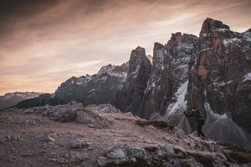
© wisthaler.com
SuuntoPlus Weather
Whether you’re out hiking, trekking, ultra running, climbing or mountain biking, it’s wise to track the weather and environmental changes. That way there will be no unpleasant surprises. The Weather insights SuuntoPlus feature on Suunto 9 Baro helps you to do just this. It gives you a heads up on the conditions while you’re out there.
A combination of functions – storm alarms, temperature readings, barometric trends, sun and moon phases and more – give you the intel you need to make smart and safe decisions in the outdoors. Here’s an overview of the weather insights you’ll get:
Sunrise / Sunset
The upcoming sunrise or sunset, depending on which is next. This tells you when to pack up and get going, for example, or how much daylight you have left to finish your activity for the day.
Temperature
Take your watch off to avoid your body heat skewing the results, and place it on something to get an accurate temperature reading.
To get a water temperature reading, place it underwater (below 10 cm/ 4 inches). After you remove the watch the temperature is shown for 30 seconds, and is indicated with a separate temperature icon.NOTE: Measuring the water temperature will affect the ascent/descent values as these are pressure based.
Estimated time of arrival (ETA)
If the estimated time of arrival goes past sunset, it will be shown in red. This gives you heads up on how you are doing for time, whether you need to speed up or have enough slack to cruise.
Barometric trend and storm alarm
The barometric trend is shown on the bottom of the screen, with the current barometric value. The Suunto storm alarm is automatically shown if the pressure drops 4 hPa (0.12 inHg) or more during a three hour period.
Oxygen level
If you are above 2000 m (6 561 ft) your watch will give you a reading on the oxygen % compared to sea level.
Read how to use Weather on your Suunto 9 Baro here.
New outdoor watch face
The new Outdoor watch face on Suunto 9 and Suunto 5 gives you a heads up at a glance. No need to press any buttons; basic info is displayed right on the face in bright colours, including – depending on your watch – sunset and sunrise times, barometric trend, and more. Read more about it here.
MyRadar
Get sophisticated weather forecasts on your Suunto 7 with MyRadar, a free Wear OS app. MyRadar has two components; conventional weather forecasting and also an impressive high definition radar display of your location with time lapse shots of the weather fronts moving around your location, as these two pictures illustrate.
The weather forecasting offers hour by hour updates, lightning and weather alerts, precipitation predictions, and conventional daily and hourly forecasting. The high definition view and the accuracy of MyRadar has made it the go to weather app for many outdoors people.
Get the app here.
Klimat
This cool little service automatically adds the weather conditions from the beginning of your activity to your training log. No need to install anything on your phone; just sign up online and you’re in business. It allows you to look back and see when you braved the rain, or were out in that last horrendous storm.
You can choose the data and style, including emoji preferences, set the format and label it according to your purpose or aim. For an extra $5 a year, you get everything the free membership offers, plus some useful additional features such as air quality data, location info, and the removal of branding.
Start using Klimat here.
Sunrise and sunset alarms
This helpful feature gives you alerts when sunrise or sunset is approaching Photographers and fishermen, for example, won’t miss the golden hour again! For Hikers, climbers and trekkers, an alarm will tell you when the sun is rising so you know it’s time to pack up and get going. Conversely, an alarm lets you know when sunset is coming, telling you how much daylight you have to play with before finding shelter.
The alarms in your Suunto 9 and Suunto 5 are adaptive alarms based on your location. You decide when the alarm goes off, depending on how much in advance you want to be alerted before the sun rises or sets.
Set Sunset/sunrise alarms in Settings -> Alarms. Learn more about alarms on Suunto 9 here and alarms on Suunto 5 here.
Storm alarm
A significant drop in barometric pressure typically means a storm is coming and you seek shelter. When the storm alarm is active, your Suunto 9 Baro sounds an alarm and displays a storm symbol when the pressure drops 4 hPa (0.12 inHg) or more during a three hour period.
Activate Storm alarm in Settings -> Alarms -> Storm alarm. Learn more about storm alarm on Suunto 9 Baro here.
When your storm alarm sounds, pressing any button dismisses the alarm. If no button is pressed, the alarm notification lasts for one minute. The storm symbol remains on the display until the weather conditions stabilize.
Moon phases
In addition to sunrise and sunset times, your watch can track moon phases. Based on the date in your watch, this feature is particularly useful if you plan to be moving at night; it will indicate how much moon light you can count on for visibility. The moon phase is available as a view on the Outdoor watch face of Suunto 9 and Suunto 5 mentioned above. Tap on the screen to change the lower row until you see the moon icon and percentage.
Outdoor insights
Suunto 9 Baro constantly measures absolute air pressure using its built in pressure sensor. This sensor plays a key role in determining barometric trends, storm alarms, temperature and more. Based on this measurement and your altitude reference value, it calculates altitude, or air pressure.
Swipe up or press the lower button to view the Outdoor insights including current altitude and barometric pressure, the current temperature and the altimeter and barometer trend graphs. To see barometric trends on a Suunto 7, you can use the Baro Trends Wear OS app.


Get key info at a glance with the new Outdoor watch face
The new Outdoor watch face for the Suunto 9 Baro, 9, 5 and 3 watches allows users to track conditions and daylight hours with just a quick glance. No need to press buttons or scroll – the essential info is presented on the screen.
Suunto UX designer Jeanette Lau supported the development and says the motivation behind the watch face was to support users with their adventure planning. “We wanted to inspire and equip users for their outdoor adventures,” she says. “We conducted some research and we learned many of our users felt as if there wasn’t enough time in the day and wanted to know what the conditions were before embarking on their adventure.”
Click to learn about 8 tools to track the weather with Suunto
For all of the above watches, the Outdoor watch face features a sun gauge that displays the number of night and daylight hours before sunrise and sunset. Tap the screen once, and the watch face displays the number of hours until sunset or sunrise, plus the battery life remaining, or the moon phase, which is helpful because on a full moon night you know you’ll have extra light to stay out a little longer.
“Most of the time we feel as if there isn’t enough time in the day,” Jeanette says. “But with this watch face, I can see exactly how much time I have for a run before the sun sets without having to do the math myself.”
On the Suunto 9 Baro
On Suunto 9 Baro watches – which have a barometer – the Outdoor watch face also displays an air pressure gauge along with current altitude. With two taps on the screen, a more detailed screen appears, displaying the barometric trend and, once they are 2000 m or higher, the oxygen percentage.
On the Suunto 9, Suunto 5 and Suunto 3
Rather than extra barometric info, on the Suunto 9, 5, and 3 watches, the Outdoor watch face includes a steps gauge that quickly tells users where they’re at with their daily step goal and how many calories they have burned.
To get the outdoor watch face on your Suunto 9 Baro, Suunto 9, Suunto 5 or Suunto 3, make sure you have the latest software version on your watch and then enter the watch face selection in your watch settings and choose the newly loaded face.
Read more articles
8 tools for tracking the weather with Suunto

Know your species of cloud
One of the fun activities to do in the outdoors is identifying different species of flora and fauna. It’s about more than knowing names; the process of identification brings us closer to the world around us and tells us what’s going in that habitat.
The same can be said for knowing the different species of cloud. Being able to recognise the different types of clouds and what they’re doing tells us what’s happening with the weather, and when our risk is increasing or decreasing. This is an especially important skill for those who spend a lot of time in the mountains.
We talked to Sarvesh Garimella, the chief scientist and COO at MyRadar, a Suunto partner, about the different varieties of clouds and what we should look out for when we’re planning to head into the great outdoors. A keen hiker since his field research days at university, Sarvesh has a Phd on ice clouds in the atmosphere. Who better to ask then? Here are Savesh’s 10 tips.
Click to find out more about MyRadar’s detailed local weather forecasts!
Download MyRadar Wear OS app here.
Respect the mountain
At a really high level, clouds are one type of information your surroundings are giving you. We can also look at recent weather and trail reports about an area. And one of the most important recommendations that has been echoed to me again and again is to know your limits and respect the mountain. There could be hazards you are prepared for and others you aren't prepared for. No climb or trip is worth your life. Be smart and live to climb another day.
The trend is your friend
In forecasting we like to say this phrase a lot: "the trend is your friend." If you’re just looking at what the barometer is saying in one moment that’s less informative than observing what the trend is. Or if you’re looking at a model of rain output, the model that came out an hour ago might not show as much output as the model that came out just now does. If you look at the next model an hour later it might be showing more rain. Each successive model is showing more and more rain or whatever phenomena. Whether it be simple observation of the environment or more sophisticated analysis of weather models, the trend is your friend. Just because you have a snapshot of what’s going on now that doesn’t mean you have a complete idea of what it could turn into, especially in a complex environment.
Sarvesh regularly hikes in the Pacific Northwest.
Know your cloud
The World Meteorological Organisation (WMO) has an International Cloud Atlas that consists of 10 genus of clouds within which there are many species of cloud. Within the species of clouds there are lots of different varieties. The WMO website has flow charts and guidance to help you identify what specific types of clouds you are looking at.
The big three
For most people I say there are only three types of clouds to think about. Those are the cirrus clouds, which are the wispy ice clouds that tend to be higher in the atmosphere. Most of the clouds you see that are puffy and popcorn-like are cumulus clouds, and those tend to be scattered and independent. Then you have stratus clouds, the decks of extensive, and low to medium altitude clouds. These are the low clouds that stretch out as far as you see that produce gentle spitting rain. There is a qualifier for various types of clouds: whenever you hear the word nimbus it refers to rain. Cumulonimbus clouds, for example, can turn into a thunder head. So the big three are: cirrus, cumulus, and stratus clouds.
1. Cirrus clouds
2. Cumulus clouds
3. Stratus cloud
Watch the low clouds
In addition to those three main types of clouds you can also classify clouds by their altitude. Low, medium and high clouds. It’s good to identify what could be happening in the low cloud decks versus the middle or high cloud decks. If you see there are a few wispy cirrus clouds in the morning, and then you see a few more in the afternoon, that could suggest there might be more moisture entering into the region, but it might not pose an immediate risk. But if your low cloud decks seem sketchy and visibility is poor you might like to wait another hour or two for the sun to come up to see if it burns off the fog. I’ve been on climbs where we’ve definitely had risk issues with the low or medium cloud deck, especially on Mt Rainier.
Not all clouds are bad
When I see a stratus deck that is low and consistent, with spitting rain, that’s a good sign for me because it means it’s not the nicest from a hiking standpoint, which means there is going to be less people out on the trail. Just because you see rain it doesn’t mean you are going to have a bad time.
Beware of lenticular clouds
Here's one particular example especially relevant for mountain climbing; a lenticular cloud. These are the lens shaped clouds that sit on top of mountains. They tend to form when you have moist air moving across the landscape, which gets kicked upwards by the mountain itself. They are pretty to look at, but what you have to keep in mind, especially on the leeward side of the mountain, is it means you get lots of vortex shedding from wind coming over the mountain. Pilots know to stay away from lenticular clouds because the turbulence there can be really bad. Wind risk can be more significant than any other type of hazard depending on the mountain you are on. If you see a lenticular cloud it suggests that there might be windier conditions as you get closer to the summit.
Watch for vertical extent
The thinner, wispy clouds higher up are less of an issue to look out for than low clouds. The stratus decks can produce steady, low intensity rain, but from a hazard standpoint they aren’t particularly dangerous. If you have instability in the atmosphere or the chance for developing thunderstorms, that is the sort of hazard you want to look out for. If you notice the cloud cover is significantly higher than it was first thing in the morning or the vertical extent of the clouds is increasing then its ability to start producing rain also increases.
Be aware of cooling
If you feel the air getting cool and if you can see the pressure is dropping this might be because a weather cell is moving towards your area. The up and down draughts and the rain and the cooling effects of the rain can change the weather pretty dramatically. That can be a sign of quickly changing weather. This is one of the reasons why My Radar has the precipitation nowcasts; they warn you when it sees a cell on a radar that you might not necessarily be able to pay attention to. Remember, the trend is your friend.
Read trail reports
The trail reports put out by the fire service, the AllTrails App and such are definitely important as well. Many of the hazards are only present if the trail is in a certain condition. If you have lots of wind that might be okay if you have lots of traction. But if you have ice on the ground and also gusting winds that’s another issue.
Add MyRadar Wear OS app on your Suunto 7 to get detailed local weather forecasts on your wrist.
Lead image: ©Philipp Reiter
Other images by Marc Thunis on Unsplash
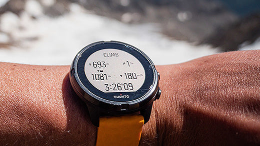

Boost your hill training with SuuntoPlus Climb
Hill repeats are an essential part of an outdoor athlete’s workout repertoire. To make the hard work pay off, pacing is key. The new Climb SuuntoPlus™ feature does just that: it gives you real-time insights on your effort and motivates you to keep going.
The same goes for longer hikes, too: once you learn what kind of ascent speeds are sustainable for you, you can use this feature to pace your way up accordingly.
To use SuuntoPlus™ features on the Suunto 9 or Suunto 5, activate them before starting an activity: Select your preferred activity type and – before hitting start – go down to the options menu and select your preferred SuuntoPlus feature, like Climb. The SuuntoPlus feature you chose, will be added and available as an extra screen during the session.
© Philipp Reiter
Top left: Ascent and climb counter
After you have activated SuuntoPlus Climb your watch will automatically detect the uphills and also create laps of them. The first climb is triggered after ascending for 10 meters.
During the climb you will see the ascent you have covered during that particular uphill on the top left on your screen. Once the climb ends, the ascent number will switch to the total number of climbs you have covered. When the next climb starts, you will again start to see the vertical meters for that individual climb.
Top right: Grade %
On the top right you have the grade of your uphill in percentages. The same goes for the downhill, too. The arrow shows the direction of the hill. The grade is based on your progress during your recent efforts.
Bottom left for running: Normalized Graded Pace
During trail running and running your running speed is shown as Normalized graded pace (NGP). Normalized graded pace is the adjusted pace, that reflects the changes in grade and intensity that contribute to the physiological cost of running on varied terrain.
Bottom left: Total vertical meters
For activity types other than running this view shows the total vertical meters covered during the activity.
Bottom right: Vertical speed
Vertical speed is a great way to pace an effort in an uphill lap. This also helps you estimate how long the climb will take for you – if you know the total ascent. The vertical speed is shown as meters per hour.
Note: SuuntoPlus Climb works best with watches that have a barometric sensor, like Suunto 9. Products without a barometer rely on GPS based altitude. This will require longer climbs as small changes in elevation may not be identified.
Lead image: © Philipp Reiter
Read more about hill repeats
7 tips to accelerating your uphill speed
Improve your running with high intensity hill repeats

Six ways to plan a route for your next adventure
An essential part of outdoor adventure is planning. The better you are at it, the smoother, safer and more relaxed your trips.
Of course, there are many aspects to planning, from understanding the topography and distances, through to knowing your group and managing rest breaks. However, knowing your route is key. When that’s sorted everything else is more likely to flow.
Whether you want to start from scratch, use an existing route or something in between, here are six different ways to create a route for your Suunto watch to guide your next adventure.
Suunto app’s route planning capabilities are very versatile. Depending on the situation you can use the most suitable option – even on the go as all these work on your mobile.
Planning a route from scratch is just one of the many route planning options on Suunto app.
Plan a route from scratch
Just opening the map and starting to draw your own route is probably the first route planning method that comes to people’s minds. Just mark the starting point and key points along the way to draw the desired route to your destination.
Tip: To help the route planning process you can choose whether you want to follow “any road or path”, “all road types”, “all road types avoiding hills”, “paved roads” or “free drawing”. Using the most suitable option will make planning more efficient.
Plan using heatmaps
Suunto Heatmaps show the tracks frequently used by Suunto community all over the globe, based on millions of activities. Turn the heatmaps on and choose the desired activity type. Suunto heatmaps are sport specific. This allows you to differentiate between activities, for example, running and trail running. Heatmaps can be on while planning routes. This enables you to see where the popular trails are.
Tip: Suunto app also has “My Tracks”, a new feature showing where you have been during the last week, month or a year. Compare your own tracks with the general heat to spot areas and trails you haven’t yet been to.
Suunto app recommends popular routes for your location.
Use popular routes on Suunto app
When browsing Suunto app’s map view, you can swipe up a menu of route recommendations: the app automatically generates popular routes for the location you have selected. Simply select an activity type, see what others have been doing and select one you like.
Tip: If you want to see more route options, zoom out or change the location for your search and tap ‘Search here’.
Use an existing activity
Would you like to do that awesome run from last year again? Or has your friend been to an interesting trail? You can use existing activities to create routes. All you need to do is tap the three dots on top right of the activity screen and select ‘Save route’. The route then opens in Suunto app’s route planner so you can name the route and sync it to your Suunto watch.
Tip: If you want to find your old activities more easily,, add a trail name, location etc in the description field. You can then search for them in your Diary on Suunto app and create routes for navigation.
You can sync routes to Suunto app from Suunto compatible route services, like Wikiloc, and get access to their planning tools and route libraries.
Sync from a partner service
Suunto app is compatible with several route planning services, like komoot, Fatmap, Wikiloc, Twonav Land, Openrunner and2bulu (in China). Connect your Suunto app account with the partner service to get routes created there to be synced with your Suunto app – and your watch. You can find thousands and thousands of routes in the partner services and also use their tools, like route libraries, desktop apps and big screen solutions. (Learn more about Suunto's partners.)
Tip: Some of our route service partners are included in Suunto Value Pack. Learn more about it here.
Import a GPX file
Have you spotted an interesting route in the media or perhaps a race organizer has offered you the race route as a GPX file? To get that route on your watch, save it in a location you can access on your phone and open it using Suunto app. (Learn how to import a GPX file on Suunto app for iOS or Android.)
Tip: You can also share or save your own routes as GPX files using Suunto app: Go to the list of your routes and click the sharing button. Then select whether you want to share the route or save the GPX file.

4 ways to navigate like a pro with a Suunto 7
We’ve all been there: you head out for a run, and it feels really good and turns into an exploratory run and before you know it you either have no idea where you are or you need to find a shortcut back because you’re running late.
No need to fumble with your phone, the Suunto 7 has your back. Read on for its four ways to find your way. All these navigation aids can be utilized during any activity type with GPS.
Suunto 7 has detailed terrain maps available for offline use.
Breadcrumbs
Like the breadcrumbs left by Hansel and Gretel, the Suunto 7 always draws the path you have travelled on a terrain map. This feature allows you to follow your tracks back to your starting point. And you don’t need to slavishly follow the exact same route back; if you like you can take a shortcut and merge back with the breadcrumb route later.
Terrain maps
To aid with this on-the-go navigation the Suunto 7 also shows you detailed terrain maps that are automatically downloaded to your watch for offline use. Suunto 7 downloads and updates local offline maps with heatmaps automatically when your watch is charging and connected to Wifi.
The downloaded map area is based on your last known location and varies from 35 km × 35 km to 50 km × 50 km (from 22 mi × 22 mi to 31 mi × 31 mi), depending on where you are located. You can also create custom offline maps for your travels and adventures away from home.
Learn more about offline maps
The more a route glows on a Heatmap, the more popular it is.
Heatmaps
Another option is to use activity-specific Heatmaps on your Suunto 7. Heatmaps are simply maps showing the most popular routes of the Suunto community. That’s really useful when you are deciding on route options or exploring a new area.
Learn how to change map style during exercise.
Create routes on Suunto app and select which ones you want to use on your Suunto 7.
Preplanned routes
Suunto 7 offers offline route navigation with detailed outdoor maps. The routes can be synced to your Suunto 7 via Bluetooth from Suunto app. You can create a route from scratch or use an existing route. Simply select which routes you want to have available on your watch on Suunto app and sync. When your Suunto 7 is charging and connected to Wifi, an offline outdoor map is downloaded for each route to your watch automatically.
You can either start navigating with a preplanned route at the beginning of a workout or later during the activity. The selected route is visible in the map view of your Suunto 7. Zoom in and out with the top and bottom buttons, or tap to see an overview of the route and get notifications if you go off path.
Learn more about Route navigation with Suunto 7
READ MORELearn six ways to create routes for your Suunto


