


Suunto Blog

Meet the unlikely Swedish triathlete
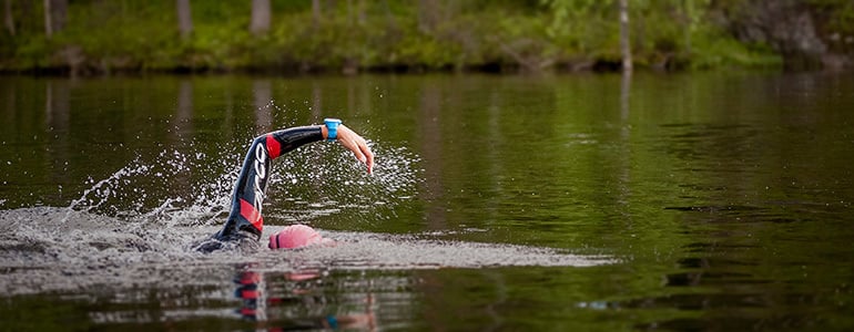
Triathlete and medical student Åsa Lundström is living proof it’s never too late to take a new sport to an elite level.A professional athlete is the last thing Åsa Lundström expected to become. A medical doctor, yes. A professional triathlete, no way.
© Petri Kovalainen
Raised in the Swedish countryside, the first time she came in contact with triathlon she thought it was mad. A high school teacher introduced the sport to the class. All the students shook their heads in disbelief. But why, they asked.The young Åsa tried swimming at high school too, but lost patience and gave up. Her main sport was football. Lacking good foot skills, it was her mission to run all over the field, hunting and wearing down the opposition.
The 30-year-old medical student is now a two-time Ironman winner, Swedish long distance champion, the Danish Sprint and Bilbao Triathlon champion. A remarkable turnaround given Åsa did her first triathlon six years ago. So, how did it happen?
After finishing high school, she traveled abroad and picked a job teaching gym classes. There, she met people doing all variety of endurance sports.
“I found I liked the long sessions and teaching several classes in a row so I got the real endurance buzz from it,” she says. “That’s when I realized I really enjoyed the time aspect of endurance sports.”
© Petri KovalainenA couple years later she began her medical studies in Denmark and there met her now long time boyfriend, a former triathlete on the junior Swedish team. With a bit of coaxing, he convinced a skeptical Åsa to train with him at a local swimming pool. He helped her swim her first 25 laps and less than a year later she competed in her first triathlon, coming 18th. After placing 4th the following year in a full distance tri, she was hooked.
“When I started with a local triathlon club, I developed quite fast and got a lot of tips from my club mates,” she says. “Seeing my own progress made me curious to know how much further I could go. “As I improved and started getting some good race results, I began to consider the possibility I might be able to compete at a professional level.”© Petri KovalainenFive years later and Åsa has prioritized her career as a professional triathlete over her medical studies. Over winter, the Suunto ambassador lives and trains in the Canary Islands and returns to Scandinavia for its warmer months. She’s come a long way in a short time.“When things get challenging or a bit rough, I find them more interesting,” she says. “Everyone wants to train or race in perfect conditions, but if there’s a bigger challenge I get more excited about that.”
Face to Face with Ueli Steck, #SuuntoAdventure Video Series Episode 6
In the sixth episode of #SuuntoAdventure Video Series you will meet one of climbing’s most spectacular talents, Swiss mountaineer Ueli Steck.
“If you are not afraid in life, it’s dangerous,” the Swiss Machine says and explains how – and why – he has changed his approach in the recent years.
Face to Face with Ueli Steck, #SuuntoAdventure Video Series Episode 6
Watch also the other episodes in the series:
Face to Face with Emelie Forsberg – #SuuntoAdventure Video Series, Episode 1
Face to Face with Greg Hill – #SuuntoAdventure Video Series, Episode 2
Face to Face with Kilian Jornet – #SuuntoAdventure Video Series, Episode 3
Face to Face with William Trubridge – #SuuntoAdventure Video Series, Episode 4
Face to Face with Conrad Stoltz – #SuuntoAdventure Video Series, Episode 5
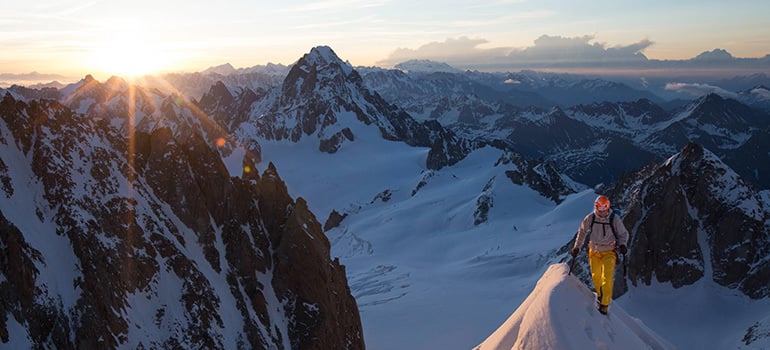

The Swiss Machine
Ever since his 2008 record-breaking solo speed ascent of the north face of the Eiger in 2h 47m 33s Ueli Steck has been regarded as one of climbing’s most spectacular talents.
Afterwards Steck declared he would dial back on the fast solo climbs that led to him being nicknamed the “Swiss Machine” but his climbing feats have continued to amaze and inspire. In 2013 he was back in the limelight after making an incredibly bold solo ascent of the south face of Annapurna (8,091 m) in 28 hours – a new record. The ascent won him the Piolet d’Or, one of climbing’s most prestigious awards.
“I was at the limits of my physical and mental ability. To go to such limits changes your consciousness, ” he said at the time. Climbers regard it as one of the most significant climbs in the Himalayas in a generation.
The older, smarter Steck is not the same climber he was as a daring youth, pushing the limits of human capability. “I feel a difference between now and 10 years ago,” he says. “My body needs more time to recover, and I have to be more careful with training. But I’m more confident, and this gives me a lot of freedom. But the fire still burns!”
As a purist, Steck climbs without using bottled oxygen and has so far summited five 8,000m peaks without doing so. Everest is one of those peaks, which, he says, was one of the most physically demanding undertakings in his life. “It’s out of the question for me to use bottled oxygen,” he says. “I either make the summit without it or I turn back, go home and train more.”
Steck is also noted for his rigorous and professional approach to training. He spends up to 30 hours a week working-out, running, climbing, cross-country skiing and doing endurance and strength work. He never travels anywhere without a pair of running shoes and is always scouting for something to get to the top of, whether a mountain in the distance or the top of a building if he’s city-bound, such as the One World Trade Center in New York City.
He says the Suunto Ambit is the perfect solution for both mountaineering and training. “It’s got everything I need in one package, whether I'm on an expedition in the Himalayas or on a hard one-day ascent in the Alps.”
But no matter what the route, Steck’s inspiration remains the same. “It’s the challenge of moving on in life,” he says. “I always want to try something I have not done before.”
Follow Ueli Steck's #82summit project here
Pictures by Jon Griffith Photography


-111 m beneath the ice
After eight months exploring Greenland, members of the Under the Pole team push their ice diving limits to new depths.
The descent was five-minutes only, but the small hole dug in the ice 111 m above would demand a two hour return trip – in sub-zero waters.
In the icy darkness 111 m below the surface and the rest of the Under the Pole team, Martin Mellet and Ghislain Bardout smiled at one another – they’d reached a difficult new “summit” together.
© Lucas Santucci/Under the Pole
Like ambitious alpinists trying to reach the next peak, they are always tempted to descend to the next “summit” below them. Unlike alpinism, however, deep sea diving has no ultimate summit to reach. The deeper you dive, Martin says, the more complicated the dive becomes while at the same time not satisfying the craving for an ultimate end point.
“This frustration is a powerful motivation for deep diving, but a dangerous one because you constantly need to control the urge to go further,” he says.
Only two things would ensure their safe return; their trust and confidence in each other and the thin lifeline leading them back to the hole in the ice ceiling. “We get in the water through a small hole in the ice, and this opening is our only way out,” Martin wrote after the dive. “If we lose track of the life line that connects us to the hole, things can only end in tragedy.”
© Lucas Santucci/Under the Pole
The visibility was poor when they began their descent, but their spirits were high. After eight months of hard work and diving together as part of the Under the Pole expedition, Martin and Ghislain had achieved a level of trust to make such a risky dive possible.
On their descent to 90 m, they had dove along a steep, reassuring cliff face. After that, the cliff ended and the vast ocean expanded before them. “Everything was calm and quiet, intensely exhilarating,” Ghislain says. “We dive because we want that moment when the unimportant just fades away and everything we feel is suddenly amplified by our heightened senses.”
© Lucas Santucci/Under the Pole
At 111 m they stopped and contemplated their surroundings and situation. Going further was unnecessary; they were already deep enough.
“Being there, 111 m below the sea ice and icebergs, is a big deal – at that extreme depth, our lives were pending,” Ghislain says. “Like an alpinist who has reached his summit, we had just reached ours and it was time to ascend.”
To avoid decompression, the return trip took two hours, with 1h 30 spent at 12 m and above. But this meant they could take their time on the way up and better enjoy the dark shapes of the huge icebergs above them.
“After a little more than two hours, we emerged from the hole one after the other and entered a different world where the team welcomed us with satisfying smiles, cake and hot tea,” Ghislain says.
© Lucas Santucci/Under the Pole
Ueli Steck's incredible summer adventure
Most alpinists are happy when they summit two or three peaks during a trip. But then Ueli Steck is not your average mountaineer. Yesterday, the Suunto ambassador embarked on an epic summer challenge – to climb 82 4,000 m peaks in the Alps in 80 days with the German guide, Michi Wohlleben. Even more challenging, the pair plan to cycle between each stage. In all, they'll cycle 1,000 km and climb 100,000 m of altitude.
www.82summits.com
Amazingly, Steck says the trip is all about calming down, taking his foot off the pedal and not pushing records but just doing what he loves. “It’s about a message I want to send, to myself as well,” he told Swiss newspaper NZZ. “The message is that striving for records bears risks. If I stay in this routine of always going faster, higher, further I know that it will at some point have a deadly ending.”
The pair reached the first summit, Piz Bernina, yesterday. 4049-meter high Piz Bernina is the most easterly 4000-meter peak in the Alps.
Stay tuned for more updates!Main image by Jon Griffith Photography

Why runners need to mix it up, says Ryan Sandes
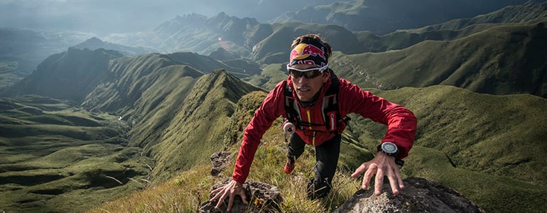
In part two of this three part series, Suunto ambassador Ryan Sandes offers more tips to help you become an ultra runner.
1. Focus on your goals
It's important you have a schedule and that you know where your peak weeks are and when you need to back off and at the same time that schedule needs to be really flexible. Some weeks you just might not feel up to it, whereas others weeks you feel on top of the world and can maybe even do a bit more. The training schedule allows you to know where you're going and enables you to focus on your goals.
South African ultra runner Ryan Sandes. ©Kolesky/Nikon/Red Bull Content Pool
3. Mix it up by cross training
Strength work, a little mountain biking. cross country skiing, ski mountaineering are really great to help become a stronger runner. Doing strength work is a completely different stimulus and good balance to long distance running as it helps to prevent injury. For guys who are really heavy a long run can really take it out of you. Doing it on a bike might be better. Swimming can also help. Aqua jogging is also quite good as it stimulates your cardiovascular system and also aids recovery.
4. Go hot and cold
Doing regular sessions in a sauna also helps. It increases your production of testosterone and stimulates recovery. Cold showers, cold tubs... they reset your neuromuscular system. Try different things and see what works for you. A lot of people break themselves by doing the same type of training so it's important to mix it up.Ryan checks his Suunto Ambit once every 30 minutes. ©Kelvin Trautman / Red Bull Content Pool
5. Warm up properly
Often before I run I do ten to fifteen minutes of basic mobility work to make sure everything is moving. People working a full time job might say they don't have the time, but I think you can do two or three minutes to warm up before you start running. Doing side bridge, push top leg back, basic mountain climbers bear crawls, basic lunges etc.
6. Quality over quantity
Running a high mileage works for some people, but it’s important you don’t follow others blindly and instead find out what works best for you. Doing more quality training and dropping the quantity is definitely a good idea. For beginners, it’s better to do less and to focus more on recovery.
Click here to read the first installment in this three part series from ultra running champion Ryan Sandes
7. Find your breath
It’s important to train your diaphragm as well as your legs. One of the first things that will slow you down and make you fatigued is poor breathing. Your diaphragm is almost like a muscle so you need to train it as well. Practice deep belly breathing and you will improve your oxygen intake.
8. Break it down
With ultra distance running you’ll constantly go through highs and lows and how you manage those will decide how your race will end up. It’s so important to stay positive. To help with this, try to break a long run or race down into lots of mini goals. Focusing on getting to the next aid station, for example, or getting up the next climb or to the next tree can trick your mind and make it all more achievable.
9. Get absorbed
When you’re doing your long trail runs it’s important to have fun and to get absorbed in your surroundings. I know a lot of guys who come from a marathon or 10 km background and they constantly look at their watches and worry about how many minutes each kilometer is taking. This makes it difficult for them to enjoy themselves. I look at my watch once only every half an hour because it boosts my motivation to know how long I’ve been out, how far I’ve gone or how much I’ve climbed.
Setting mini goals throughout the race helps to stay positive. ©Kelvin Trautman / Red Bull Content Pool
10. Go social
A lot of people like running on their own, and that’s cool, I enjoy it too, but it’s also nice to mix it up and run with other people. It makes it more fun. You’ve got to be careful if your trail buddies are a lot faster than you. It can be good for them to push you a little bit, but don’t do all your runs with them if you’re a lot slower. Do half your long runs with them and then go off on your own.
Regular strength training helps to prevent injury, Ryan says. ©Kolesky/Nikon/Red Bull Content Pool


